The doubtful Douro

A reassessment of a well-known wreck site

The site known as the Douro has been charted since 1980 in the vicinity of the Round Rock of Crebawethan to the south-west of the Scillonian archipelago after having been discovered in the late 1960s. The site assemblage consists principally of manillas, a form of brass currency, and blue and white glass aggry beads, both known to have been consigned for west Africa. Knives have also been recovered. There has also historically been reference made to ‘a lot of pistol side plates’ and ‘hundreds of brass keyholes’ which have added an air of mystery to this wreck. [1]

An ancient, greenish bronze artifact shaped like a curved hook with pointed ends, set against a black background.
Manilla from the site known as the Douro, © The Trustees of the British Museum.
Shared under a Creative Commons Attribution-NonCommercial-ShareAlike 4.0 International (CC BY-NC-SA 4.0) licence.

The Charming Kitty of 1763 in Historic England’s marine records, wrecked at Howick, Northumberland, provides a useful comparator. She was bound from Hamburg to Africa, having been captured on route from St. Kitts for Senegal by a Moroccan xebec, and sent for Saffi on the Barbary Coast (now Morocco), whence the English crew were taken up by Danish and Dutch merchants. The vessel was then sent to Hamburg, presumably as part of the price of the other Europeans’ ransoming of the English crew and vessel, and was on her way therefrom when wrecked. (This in turn suggests she was significantly off course and driven north-west by a south-easterly wind.)

No armament parts are recorded, but an advertisement for the cargo reveals ‘bugle’ or trade beads, knives and padlocks [2], and these were among goods typically used as exchange cargoes for slaves.

The site was first identified as the Douro in 1971 [3] with an unsourced reference to its cargo of ‘armoury and brass stops” which has never been traced, which has further deepened the mystery over this wreck.

The Sunderland-registered Douro was built in 1839, and, as her name implies, she appears generally to have been a regular trader to Oporto and a specialist in the city’s eponymous port wine. Things changed in late 1842 with two Anglo-Portuguese treaties in late 1842, the one a commercial treaty and the other a treaty ‘for the suppression of the slave trade’, both subject to protracted negotations. ‘By the treaty relative to the slave trade, Portugal undertook to punish her own delinquent vessels’, demonstrating that there remained some Portuguese involvement in the trade, despite abolition there in 1836. The debates over the negotiations and the tariffs imposed by Portugal were known as the ‘Douro question’. [4]

A watercolor illustration of the samdbank or Bar of Oporto visible at low water from the fortified Sea Battery in Portugal (nearest the viewer in the foreground). The battery and the viewer look out across the river in the middle distance, with both local vessel types and larger European vessels plying the river, toward the hills in the background.
A familiar sight to the visiting Douro, as seen by Captain J F Boxer, RN: The Bar of Oporto from the Fog Battery, Portugal, 1836
ZBA1548 National Maritime Museum, Greenwich, London

So what on earth was a British vessel doing with manillas and aggry beads and other cargoes known to have been used in the purchase of slaves, when abolition had taken place in England in 1807 and in Portugal in the more recent past? Curiouser and curiouser – what was she doing, and was she involved in clandestine trade to Portugal’s former colony Brazil, which would not completely abolish slavery until 1888?

We know that the Douro left Liverpool on 18 January 1843 for Oporto. Was she then going onwards illegally (in both Britain and Portugal) to Africa?

On the night of 26 January 1843, the Douro ran ashore among the Western Rocks, Isles of Scilly, the site known as the Douro located by the Round Rock of Crebawethan. She was seen by fishermen the following morning dismasted and thrown onto her broadside ‘with the sea making a complete breach over her’, which suggests some roughness to the sea, and no one was found, which suggests likewise. It seems that the loss was due less to a storm, even in rough seas, than to ‘thick weather’. During the course of the morning the vessel ‘bumped so heavily upon the rocks that she soon went to pieces and part of the cargo came ashore. [5]

A satellite image showing Round Rock, marked with a yellow pin towards the upper left/NW of the image
Round Rock of Crebawethan, north of Great Crebawethan (r) and Little Crebawethan (l) among the Western Rocks, Isles of Scilly, a veritable ships’ graveyard.

That cargo was reported as ‘Manchester goods’ and ‘bale goods’ specified as cotton twist and printed fabrics, a cargo consistent with a Liverpool departure, and possibly at least one other vessel was lost among the Western Rocks of the Isles of Scilly that night. [6]

Was the reported cargo a cover for the illicit cargo? Did the manillas sink with the vessel while the fabrics floated away?

There is also a discrepancy in the contemporary reports for the Douro‘s loss with the site’s known position. She is consistently reported as having bumped over ‘rocks’ in the plural, and the cargo seen ‘on the rocks’, whereas the Round Rock of Crebawethan is a single large rock, not a grouping. At no time was the Round Rock specified in any contemporary reports, and the ship was reported by local boats, which implies strong local knowledge and clarity on the location. Similarly, no one reported any of the cargo that characterises the known site. This wreck becomes more and more problematic the more we look at it.

The vessel’s logbook was discovered shortly afterwards, entering her cargo, and she had ‘cleared out’ from Liverpool, indicating that she had passed Customs outbound. This would suggest that her cargo was entirely legitimate and active patrols by British ships against the slave trade would have meant that a clandestine cargo was a significant political risk. It is true that Manchester and Lancashire cotton textiles were intertwined with the slave trade, the raw materials being sourced from slave labour in the Americas and exported as textiles as an exchange cargo for people.

However, textiles were legitimately exported worldwide, including West Africa. Both textiles and manillas tapped into the existing networks established by the slave trade, repurposed for palm oil instead, and both continued to be sent to Africa post-abolition, the one as a cargo for sale, the other as a currency, both in exchange for palm oil. Other wrecks are known from this post-abolition trade, for example, the brig Hope, also among the Isles of Scilly, while bound from Ghana for London in 1830. [7]

It therefore seems unlikely on location and cargo grounds that the vessel at this site is actually the Douro. The ‘armoury and brass stops’ reference remains untraced and it appears both obscure and archaic for an 1843 cargo. It cannot be made to fit the assemblage at the site and neither works as a description for the manillas, to which they have historically been assumed to refer. Until the reference is properly sourced, ‘armoury and brass stops’ must be regarded as a red herring which sheds no light either on the site itself or on the Douro. In summary, the documentary record for the Douro corresponds poorly with the artefact evidence and raises more questions than it answers.

Only one other vessel has historically been reported as having been lost at the Round Rock, Crebawethan, the English fishing lugger Cornish Girl, in 1873, which, from the nature of its trade, can be excluded as the source of the manillas. Seven other vessels have been recorded in the wider Crebawethan area, but none are a good fit and can be readily excluded.

It is clear that in any scenario pre- or post-abolition the vessel concerned was travelling to Africa: all the clues among the cargo – the manillas, the aggry beads, and the gun plates – all point to a West African destination. While characteristic of the late 17th and 18th century slave trade, such cargoes also persisted into the post-abolition and colonial eras: post-abolition, beads were exported to Africa, as demonstrated by those sold from the Juno, bound from London for Senegal, in 1812. [8]

The cargo in itself suggests that the vessel was wrecked outward-bound, and it appears to be in an easily accessible and choherent assemblage, rather than a scattered debris trail, so that it seems most likely that the wreck event was one of rapid sinking in a ‘straight down’ event, following the initial shock of contact with a feature such as a rock – not bumping several times over more than one rock, as was recorded with the Douro. Therefore, the Douro does not fit in manner of loss either.

The mystery deepens. Who or what was the ship wrecked at the site known as the Douro?

A good candidate emerges in the loss of the barque Custos, of and from Liverpool for Bonny in Nigeria with a general cargo. On 28 August 1856, she struck on a rock in a location variously described in contemporary accounts as the (less specific) Western Rocks, or the more specific Crim Rocks, Crim Rock, and the Crim Reef., not very far from Crebawethan. [9]
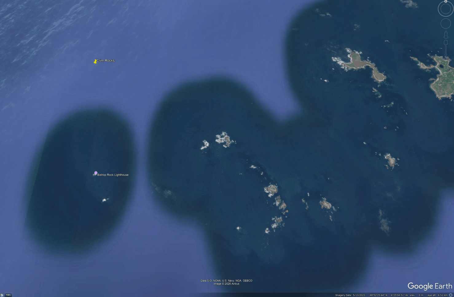
A satellite view of the Western Rocks archipelago, with a yellow pin towards the NW/upper quarter of image, locating Crim Rocks
Crim Rocks, north-west of the main body of the Western Rocks, Isles of Scilly

She ‘very soon became a total wreck. The master and crew – 17 in number – took to a boat, and were safely landed, having saved very little beyond what they were wearing at the time of the vessel striking the rocks’ [10]

Variations in recording the location of loss in contemporary accounts regularly occur, while it is not at all uncommon for a wreck site, when found and identified, to lie some distance from the reported location of loss, or from where she initially struck – even where a very specific feature is reported, such as the Crim Rocks. In this case the distance between the Crim and the Round Rock of Crebawethan is 1.75 miles.

The crew survived and took to their boats, apparently landing by their own efforts (rather than local boats attending the wreck, as in the case of the Douro, or picked up at sea by another vessel). It seems probable, therefore, that the initial report of the location came from the wrecked crew, therefore, not from locals. Nor does the advertisement for sale of the salvaged cargo state where it came from other than the vague ‘here’, representing the Isles of Scilly.

In that respect it may be significant that the least specific location, the Western Rocks, comes from the most local paper, and the more specific ones, in terms of naming the location as the Crim, from the national or London press. This suggests that the position of loss as reported by the crew is the one which most probably was reported to Lloyd’s agent, and is thus the version which made its way into the national press.

In other respects, the regional newspaper contains the longest and fullest account and thus, as was usual with local wreck reports, has been synthesised from more than one source. It was published later than the other accounts, on 5 September 1856, and is therefore based partly on observation in the days following the wreck. It draws attention to the salved cargo and suggests that ‘Western Rocks’ is based on observation of the dispersal of wreckage locally; it also suggests that by that time the vessel had disappeared from view even in potentially less than 10m of water as she ‘very soon became a total wreck’. The wreck account for the Douro demonstrates how quickly this could happen.

The Custos‘ salvaged cargo included the following:

‘ . . . 31 pipes and 55 Quarter casks Rum; 25 Bales of Cotton Goods; 49 small boxes soap; 191 Muskets; 2 casks Gun flint; 136 Barrels of Gunpowder; 4 Bags of Manillas; 2 Cases of Matches; and a lot of Staves and Sundries . . . ‘ [11]

Similarly, the bulk of the salved cargo appears to be goods which would have easily floated or potentially been accessible in on a ship resting in the upper holds at less than 10m as charted: barrel (rum, gunpowder), bale (cotton) and case goods (matches), and soap, but a limited quantity of heavier goods, such as the muskets and manillas, were also saved.

The heavier salved goods may therefore represent remains from any portion of the vessel still upon the rock.

The contemporary records of the salvaged cargo are consistent with the African trade even in the post-abolition era and is also consistent with observations on site, namely the muskets, whose ‘pistol plates’ survive, and the manillas.

Further, the reference to manillas is the sole instance so far recorded among the wrecks in Historic England’s database of a contemporary reference to a manilla cargo, and thus the only vessel to be explicitly recorded with a cargo of manillas, This in itself is not necessarily conclusive, but, in tandem with being recorded in contemporary sources as less than 2 miles away, likewise on the seaward side of the Isles of Scilly, is another piece of circumstantial evidence that the wreck is not the Douro, but the Custos, particularly given the security of the evidence that manillas were associated with the wreck (contemporary salvage).

The lack of physical vessel remains is consistent with both the site environment (rocky gullies) and the reported rapidity of the Custos’ loss, and the loss event is interpretable as characteristic of a loss to a single rock at the site where it lies, rather than reef or group of rocks, which seems to have been the case with the Douro.

The rapid sinking is also consistent with the predicted ‘straight down’ loss event legible in the easy accessible and coherent assemblage from which many manillas have been recorded over at least 50 years.

The Douro therefore probably lies at Crim Rocks, which fits the description of the site of loss, and the Custos is the wreck at the Round Rock of Crebawethan, not at Crim Rocks.

The only factor preventing 100% certainty that the vessel is the Custos is the contemporary attribution to the Crim Rock(s), but, as stated above, this difficulty is not insurmountable given the proximity of the Crim Rocks to Crebawethan, and such discrepancies are characteristic of wreck identification processes in any case (see, for example, our blog on the Erard Harp, where the wreck site was some miles distant from the reported location). But, on the balance of probabilities, the likelihood that the wreck is the Custos is very high.
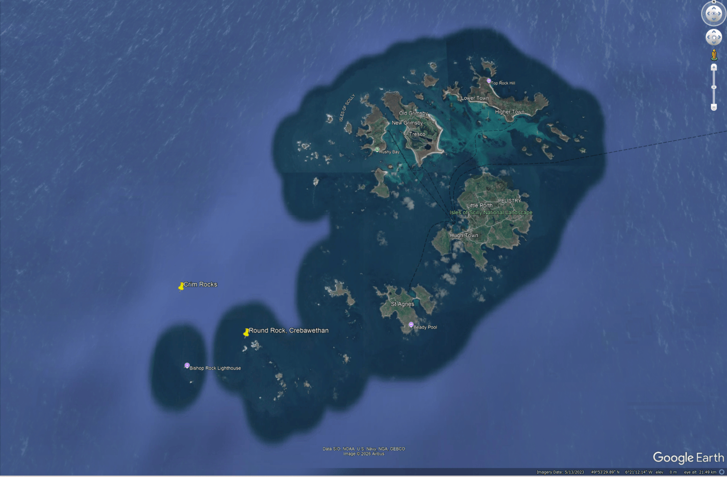
A satellite image of the complete Isles of Scilly archipelago, with the two yellow pins of Crim Rocks (above) and Round Rock (below) in the lower left quarter of the image, showing that they are only 1.75 miles apart
Location map of the Isles of Scilly showing Crim Rocks and Round Rock of Crebawethan, 1.75 miles apart.

The contemporary attribution may in itself be a clue to the cause of loss – navigational error – particularly as it seems that it might well have originated from the crew themselves, and that they were not properly able to identify the location of loss. For over 150 years their report has misdirected attention away from a plausible identification for the manilla site. At the same time, the Douro was lost in ‘thick weather’, indicating fog, so, again, there would not have been perfect clarity as to the location of loss.

By naming the Custos, all the mysteries have been solved: the Douro‘s name has been cleared: not a vessel engaged in clandestine support of the slave trade but a legitimate specialist in the port wine trade, as she had always been, and the Custos is now the most plausible candidate that explains the presence of manillas in the post-abolition era among the Western Rocks.

It also strikes me that this blog, together with the last two, make a complementary trio and strangely, although this wasn’t intentional, the previous two do hint at this one: the Adgillus, like the Custos, was bound to West Africa from Liverpool, for the Victorian palm oil trade. Like the Dom van Keulen, some of the cargo is in the collection of the British Museum (used to illustrate the blog) and other museums around the UK, and we have made an identification on the balance of probabilities through careful examination of the original sources (and we have also made mention of Safi – which was also in the Dom van Keulen blog!)

We complete a circle as we identify a long-problematic site.

[Article based on a much longer unpublished report by Serena Cant for Historic England, 2021]

Footnotes

[1] reported from the site in the 1960s

[2] London Evening Post, 5 to 7 January 1765, No.5,655, p2

[3] Larn, R 1971 Cornish Shipwrecks: the Isles of Scilly (Newton Newton Abbott: David & Charles)

[4] See Hansard, House of Lords debate, 2 August 1842, Vol. 65, cc935-6, and 9 August 1852, Vol. 65, cc.1178; press reports e.g. the Dublin Evening Post, 4 February 1843, p2

[5] Morning Post, 03.02.1843, No.22,479, p3

[6] Lloyd’s List, 02.02.1843, No.9,017; Historic England Marine Historic Environment Record entries for the other ships lost that night.

[7] Historic England Marine Historic Environment Record entry for the Hope, 1830

[8] Historic England Marine Historic Environment Record entry for the Juno, 1812

[9] Respectively the Royal Cornwall Gazette 5 September 1856, No.2,775, p5; Lloyd’s List, 1 September 1856; Morning Post, 2 September 1856, No.25,793, p8, and the secondary source Larn R & Larn B 1995 Shipwreck Index of the British Isles, Vol.1: Isles of Scilly, Cornwall, Devon, Dorset (London: Lloyd’s Register of Shipping) which, from internal evidence, has been sourced from a contemporary inquiry into the event, not referenced in that text.

[10] Royal Cornwall Gazette, 5 September 1856, No.2,775, p5

The Dom van Keulen wreck of 1633

A gold coin featuring Arabic inscriptions enclosed in a square on both sides.
Gold coin of Zaydan Abu al-Ma’ali al-Nasir, 1603-1628, Morocco, from the Salcombe Cannon wreck site.
© The Trustees of the British Museum. Shared under a Creative Commons Attribution-NonCommercial-ShareAlike 4.0 International (CC BY-NC-SA 4.0) licence.

For this blog we are going to do something a little different: a conversation between Serena Cant, Maritime Research Specialist at Historic England, and Ian Friel, maritime historian and consultant, who has recently identified the designated Salcombe Cannon wreck as the Dom van Keulen, lost in 1633. He is one of the contributors to the British Museum’s 2026 publication From Morocco to the Coast of England: The Story of the Dom van Keulen and its Remarkable Cargo, available as a free download from the British Museum.

Serena: Ian, congratulations on identifying the Salcombe Cannon wreck, now known as the Dom van Keulen. Before we start, I’d just like to introduce you a little bit to our readers and talk about some of the things we have both been involved in. You have been instrumental in making a number of wreck identifications over the years.

Our paths have regularly crossed over designated wreck sites, we’ve been involved in some of the same cases, and share many of the same interests – medieval and 17th century wrecks, so I thought this would be great! I’d just like to say I come at this with an art history and forensic linguistic background, but let’s not get ahead of ourselves . . . but instead look at some of the things you have done.

For example, you identified a ‘ship-shape’ in the mud in the River Hamble as the Holigost, lying next to the Grace Dieu – making this stretch of the River Hamble a 15th century ship graveyard. This work resulted in the Holigost being incorporated into the existing designation for the Grace Dieu site in 2016, in which I played a part.

We were also both involved with the Swash Channel Wreck. When its rudder was raised in 2013, I was asked to look at the figure on the carving. I wrote a paper dating it to the 1630s stylistically, while you identified the wreck through your documentary research as the Fame of Hoorn, lost in 1631. We came to pretty much the same conclusion from different points of view, but of course you went one further and identified it!

Summarise why the Salcombe Cannon wreck site has posed such an intriguing mystery since it was discovered?

Ian: The wreck was investigated in 1995 by volunteer divers from the South West Maritime Archaeological Group, following up the discovery of a group of cannon and anchors on the seabed in Salcombe Bay, by another group of divers. SWMAG’s initial dive located a small gold ingot and some gold coins, which were duly reported to the Receiver of Wreck. SWMAG went on to survey the site in detail, eventually uncovering a remarkable collection of over 400 Moroccan gold coins and other gold items. The site was given statutory protection under the Protection of Wrecks Act 1973 and in 1999 the British Museum acquired the items, thanks to a grant from the Art Fund. The SWMAG divers and their archaeological advisers deserve enormous credit for their careful work recovering finds that – in a literal sense – have become national treasures.

What came to be known as the ‘Salcombe Cannon Site’ was covered in a BBC ‘Timewatch’ film (2003) called White Slaves, Pirate Gold, which made the not-unreasonable suggestion that the site represented a 17th-century ‘Barbary Corsair’, a pirate vessel from North Africa. Barbary vessels were intermittently active in North European waters from the late 1500s to the 1700s. They were notorious for kidnapping European seafarers and coastal inhabitants and taking them back to Africa as slaves. Recent research suggests that about 20,000 people were abducted in this way from the British Isles and Ireland over that period. The pirates posed a real danger in English waters in the 1630s, the date of the latest of the Moroccan coins from Salcombe.

Serena: It really illustrates the international dimension of shipwrecks, doesn’t it? The original ‘Barbary corsair’ theory was plausible, given that we also have accounts of corsairs wrecked on the Cornish coast as late as 1760 when ‘an Algerine Chebeck (xebec) of 20 guns . . . was entirely lost’. [1]

So this identification places the wreck in a very different context, at exactly the same period as the Barbary corsairs? The Barbary coast of North Africa was at one and the same time a place to be feared, but also somewhere Europeans came to trade as well?

Ian: Trade in this period offered real dangers, but some of the goods available in North Africa were so valuable – such as gold and saltpetre, a key ingredient of gunpowder – that merchants and seafarers took the risks. The Dutch, in particular, had established contacts with Morocco, and traded items such as weaponry in return for Moroccan gold and other products.

Against the high hills of the coastline under a cloudy sky, smoke rises to merge with the clouds, from a battle between a Dutch merchantman closely surrounded by smaller Barbary pirate ships, on the right. To left foreground the wreckage of a pirate ship floats upon the sea, while a group of merchant vessels hang back in the left background.
Hendrik van Minderhout, A battle between the Dutch and Barbary pirates near the coast, late 17th century. A Dutch merchantman, armed for self-defence as so many ships were, including the Salcombe Cannon site, is surrounded by Barbary corsairs: its fate will probably determine that of the other merchant ships visible in the distance. It has already sunk a Barbary ship in the foreground. BHC0876  © National Maritime Museum, Greenwich, London

Serena: It was clearly a lucrative trade, with the Barbary ‘ducketts’ or ducats that were originally on board, and you explain that the gap between the surviving written record and the numbers of ducats discovered through archaeological excavation leaves 8,100 ducats unaccounted for. What do you think became of them?

Ian: The English sources for the wreck are quite limited, consisting of the initial commission to investigate the loss from the High Court of Admiralty (HCA, the legal body concerned with maritime affairs), the testimonies of two young Dutch merchants who were on the ship, and two arrest warrants. The lack of material rather surprised me, because in previous research I had come across HCA records of Dutch wrecks that had generated a lot of paperwork. The reason for the dearth of English sources here appears to come down to the HCA’s problems in Devon: its local Devon vice-admiralty seems to have lost control of maritime jurisdiction to various towns and individuals. The aristocratic Courtenay family claimed this kind of jurisdiction in the Salcombe area, which included ‘the right of wreck’.

The legal concept of the right of wreck went back to the Middle Ages: originally, if someone owned the right of wreck on a particular stretch of coastline, then they had a right to take whatever washed up there, shipwrecks included. (See our recent blogs on Edward III and the Paston Wrecks for medieval right to wreck.) Shipowners and merchants were given some legal protection in the 13th century, with a law that decreed if a person or an animal survived a shipwreck, it was not legally ‘wreck’, and the owners had a limited time-period in which to recover their property. Material still unclaimed after that period expired could be taken by the local owner of the right of wreck.

Alongside the legal situation, of course, there was also a huge amount of wreck looting by coast dwellers, and those further afield. Ships could contain huge concentrations of valuable items, and a shipwreck could dump such a prize almost on the doorsteps of people who had little or nothing.

The law remained pretty much unchanged for centuries, and still applied in the 1600s, leading to numerous disputes, which form one of our principal sources of written evidence for shipwrecks in the period before a widespread press.

The two Dutch witnesses who appeared before the HCA recounted the last voyage of the ship, which they revealed to have been the Dom van Keulen, lost while en route from Saffia (Safi) in Morocco to Amsterdam, commanded by a man named Dirrick Peterson. The goods on board included approximately 9,000 Moroccan gold coins, which the English called ‘Barbary ducketts’ [Barbary ducats]. The two witnesses’ testimonies were virtually identical, and the senior of the two survivors was Jacob Israel de Port, aged about 29, who said that the ship put into a foggy Salcombe Bay because it was leaking so badly, having encountered storms, and the master feared that it would sink. The crew and the two young men all got to shore safely (so the wrecked vessels and its contents were not legally ‘wreck’).

The master had taken 500 gold coins from the chest on board to provide his crew with enough cash to get them home, but had not told his men just how much gold was on board, for fear that they might cut his throat in order to get it. Neither witness saw the ship sink, but the assumption was clearly that the rest of the gold had gone to the bottom with the Dom van Keulen.

One of the arrest warrants names the owners of the cargo as two Amsterdam men called Joao de Pas and Andrea de Azevedo. This opens up some very unexpected connections with the Dom van Keulen story – both were Portuguese Jews, part of a sizeable community of Iberian Jews in the Netherlands who had fled Spain and Portugal in order to escape the Inquisition. For the time, the Dutch Republic showed a remarkable degree of tolerance for these refugees, who were also of course opponents of the Republic’s arch-enemy, the Spanish Empire. Jacob Israel de Port and his colleague, Samuel de Pas, were also evidently Jewish.

I do not read Dutch, though was able to find out something more about Joao de Pas and Andrea de Azevedo and their contemporaries from a large number of documents about the 17th-century Jewish community in the Netherlands that have been published in English.

Historic black and white etching of a man with a beard and a wide-brimmed hat swept upwards from his head, and a wide-collared shirt, typical of 1630s wear.
Rembrandt etching, the sitter traditionally believed to be Rabbi Samuel Menasseh ben Israel of Amsterdam, who became a key figure in the 1655 Readmission of the Jews to England under Cromwell.
© The Trustees of the British Museum. Shared under a Creative Commons Attribution-NonCommercial-ShareAlike 4.0 International (CC BY-NC-SA 4.0) licence.

It’s an extraordinary story in many ways and shows how items found off a Devon bay can open up connections with places very far away from Salcombe in both time and space.

Serena: For me it is interesting because we have a record for the Greyhound, which stranded in another Devon bay, Bigbury Bay, in 1782 while bound for London with a very similar cargo of gum, almonds and Barbary ducats. [2] There were rumblings over ducats that subsequently went missing. Salvage of an illicit kind by what they would at the time have called ‘the country people’ i.e. local inhabitants! Is that plausible?

Ian: The English sources say nothing about what happened. With the 400 or so coins found on site, and 500 that Peterson is said to have shared with his crew, we are still left with about 8,100 coins that cannot be accounted for. One possibility is that the coin chests were salvaged from the wreck soon after the sinking. There was a Dutch salvor called Jacob Johnson or ‘Jacob the Diver’ was very active in Britain and Ireland at this period, and is known to have raised some cannon from a wreck at nearby Dartmouth in 1629. We don’t know what kind of diving equipment he used but it is very clear that he was the ‘go-to’ man for marine salvage in England at this time. However, Dutch sources (below) give a different account of what took place.

Serena: In the book you allude to the fact that the records fizzle out to an extent: we don’t really know why that is?

Ian: The lack of records is probably down to two things, the HCA’s problems in enforcing its writ in Devon, and – if, as seems likely, the gold was stolen – the need of the perpetrators to keep things quiet.

Serena: For me, it is one of the frustrations of shipwreck research: documentation is often extensive, but only up to a point! For example, I know of a Portuguese merchant who insisted on recompense for theft from a wreck over nearly two decades in the early 14th century, but the records then die out and we don’t know the outcome. [3] I rather suspect that the case fizzled out because most of the people involved had died after that length of time!

Ian: My research on the Salcombe finds was just a part of the work on the project. The British Museum commissioned extensive researches by a group of expert archaeologists, numismatists, jewellery specialists and others, and this was published by British Museum Press this year, as you say in the introduction.

I remarked in my chapter that more information might well be available in the Dutch archives, which has proven to be the case. The publicity about the identification of the Salcombe wreck reached the Dutch media, leading to a response from the Stichting Maritieme Historische Databank (Marhisdata) in the Netherlands. Their project focuses on systematically researching historical shipwrecks through archival sources, transcribing and translating original documents using specialised software. They have information on the Dom van Keulen from Dutch sources, which contradicted what the two young men said to the HCA, and accused one of them of a crime.

I haven’t had a chance yet to examine this information in detail, but the upshot is that the insurers of the voyage accused Peterson, his crew and Jacob Israel de Port of deliberately scuttling the ship by boring holes in the bottom. It was they who initiated the arrest warrants in England.

However, this dramatic allegation seems to be no more than that – an allegation, without actual evidence of a crime. None of the timbers or planks of the Dom van Keulen survive on the seabed, so there is no way of looking for forensic evidence in the way of hull boards with holes where there should not have been holes.

It is not impossible that the ship was scuttled – there was no shortage of seagoing criminals in the 17th century – but one cannot help but think that it was easy for the merchants and insurers to put the blame on those who were on the ship for the loss and to cast them in the worst light possible.

There does not seem to be any evidence of what happened to Peterson or Israel de Port. The HCA issued warrants for the arrest of Peterson and the ship’s pilot (navigator) Jacob Clausen, but neither man seems to have been apprehended, and no sign has been found of a warrant for arresting Jacob Israel de Port. The HCA had officials or semi-official ‘commissioners’ it could instruct to carry out tasks, but no actual police force of any kind, and it was probably quite easy for fugitives to disappear, especially if they were sailors who could sign aboard another ship with few questions asked. We will probably never know the full truth of what happened in the Dom van Keulen case, though I hope that more documents might emerge in British or Dutch archives to shed light on the story.

Serena: It’s one of the joys and frustrations of documentary research, isn’t it? What sources did you use, and how easy are they to access and use?

Ian: The main cache of High Court of Admiralty records is at The National Archives in Kew. Researching there is open to anyone who can prove their identity and address, so it’s open to a much wider range of people than just academic researchers, and many people go there to pursue family history or some other kind of personal research.

In order to tackle the 17th-century HCA records firsthand, though, you need to be able to read the handwriting and to understand both Latin and the English of the period. It’s possible that in the future AI will be able to transcribe and translate it, as is being done in the Netherlands, but I’m not aware of a programme of this kind at the moment in the UK. That said, volunteer researchers contributing to the Marine Lives project have put a lot of transcriptions and studies of 17th-century HCA material online.

The documents vary a lot in physical terms. Some consist of individual documents, others are in leather-bound volumes, while yet others consist of groups of documents attached to each other, like big 17th-century jotters. Some of the HCA records are indexed, but there is often no substitute for ploughing through a vast amount of material in a search for relevant evidence. It took me a long time to find anything about the Dom van Keulen, and I was greatly relieved when I spotted the word ‘Salcombe’ in a document!

One general thing I will say about researching the identities of wrecked ships is that it can be a case of trying to balance probabilities. You need the best possible archaeological evidence and the best possible written evidence: in the case of the Dom van Keulen, the upshot of the testimony was that the ship sank near Salcombe in 1633 while carrying a large number of Moroccan coins. The Salcombe Cannon Site was clearly the wreck of a ship from the age of sail that contained hundreds of Moroccan coins, the latest of them minted in 1632. The probability that the Dom van Keulen and the Salcombe Cannon Site were one and the same was so high as to be, essentially, a ‘no-brainer’ once the HCA evidence emerged.

This is far from the case with all wrecksites discovered by archaeologists and others. The number of shipping casualties was horrifyingly high in the 19th century, when we get the first systematic government statistics about marine losses. There are no absolutely certain statistics before that date (except, for naval shipwrecks, which recorded because they were stated property. The further one goes back into the past, broadly speaking, the amount of written evidence declines. This means that anyone researching the identity of a ship has to take an absolutely forensic approach to the evidence, and accept that, in many cases, it may not be possible to conclusively identify a vessel. It can be a frustrating process, but it is also intensely interesting.

Serena: As you rightly say in the book, the name and affiliations of the ship form something of a mystery. Keulen is the Dutch spelling for Köln, Cologne in English. Why would a Dutch ship be named after the Dom of Cologne, i.e. Cologne Cathedral? Do you think it is a German vessel in origin? It’s so different from other Dutch ship names of the era.

Ian: The origin of the ship is still uncertain. The Dutch sources show that is was a vessel of around 200-240 tons, but don’t say anything about where the ship was built. Cologne Cathedral was a Catholic institution, and to name a Dutch ship after it was unusual in the largely Protestant Netherlands. In a 1631 list of 91 Dutch warships, only six had overtly religious names, so the Dutch may not have been keen on the practice in any case.

One thing I would say about this is that it was not at all unusual for ships of this period to have more than one name during their service careers. Names could change on new ownership, or to disguise a vessel that had been used for piracy, and sometimes ships were recorded with their aliases, like the English ship Swan of 1653, alias the Bunch of Blackberries.

Historic oil painting of a street in Cologne on a sunny day with clouds in the sky and the sun casting shadows on calm scenes of isolated people going about their business. The unfinished tower of the cathedral can be seen to centre right, with the crane on top of the tower a recognisable feature of the city for centuries.
Jan van der Heyden, A View in Cologne, about 1660-5, showing the half-built Dom or Cathedral that would not be completed until 1880. The Dutch artist Jan van der Heyden is known to have travelled at least twice to Cologne, and to have painted several views of the city. Other Dutch artists such as Lambert Doomer did the same, suggesting that there were cultural as well as trade contacts between the Netherlands and Cologne in the 17th century. [4]
National Gallery, London, NG866 Creative Commons CC-BY-NC-ND 4.0
Historical oil painting of a light and bright but plainly adorned church, with Gothic arches and prominent columns on which hatchments (heraldic devices) are displayed. To the left a man stands in a pew, dwarfed by a column, with a dog jumping up in front of him, and he faces a beggar seated at the plinth of a column to the right.
Pieter Saenredam, The Interior of the Grote Kerk at Haarlem, 1636-7, illustrates in both name ‘Grote Kerk‘ (not Dom or Kathedraal, both ‘cathedral’ in Dutch) and the ordering of the physical space the change towards Protestantism in the Netherlands, having formerly been Haarlem’s cathedral in the Middle Ages.
National Gallery, London, Salting Bequest, 1910 NG2531 Creative Commons CC-BY-NC-ND 4.0

Serena: I agree with these observations: Dutch names such as Eendracht (Unity) were common and popular, reflecting general virtues, rather than saints or holy places. For me the name of the ship is almost the most fascinating thing about it. Ship names might not tell us about the wreck process, but they yield so much other contextual information.

I’ve never come across a name like the Dom van Keulen in the 17th century in over 30 years‘ maritime research: the nearest I can think of in contemporary Dutch sources are names such as Wapen van Edam (Arms of Edam), which reference civic pride in Dutch cities, but never a feature belonging to another political entity. Wapen van Edam was anglicised when captured by the English to Black Bull (the main feature of the arms of Edam), as it was meaningless in English otherwise, and wrecked in the Anglo-Dutch Wars in 1666, so that ties in with what you’ve said about the changes in ship names.

Dom van Keulen seems to me to be a very modern concept somehow – the sort of name that would be bestowed on ships by the great 19th and 20th century shipping lines, named after the places they enabled passengers to reach. It’s really intriguing!

So adding the identification of the Dom van Keulen has closed one chapter – a concrete identification for a wreck that has long puzzled specialists – but opens up another fascinating trail.

Will further research on the wreck continue?

Ian: I have no personal plans for further research on this, but there may be more to be learned from Dutch and English sources, if anyone would like to pursue it. It also strikes me that, in the right hands, this open-ended story could become the basis for a good historical novel!

With many thanks to Ian for participating in this interview and sharing with us the latest instalment in a mystery nearly 4 centuries old!

Footnotes:

[1] Newcastle Courant, 11 October 1760, No.4,385, p1

[2] Sherborne Mercury, 22 April 1782

[3] Navis de Jehsu Christi: Calendar of Patent Rolls, Edward II, Vol.3, 1317-21, and Edward III, Vol. 3, 1334-38; Parliament Rolls of Medieval England, Edward II, October 1320 (British History Online)

[4] For a view of Cologne Cathedral by Lambert Doomer, and the background to cultural connections between Cologne and the Netherlands, see Stefes, A 2025 ‘Expedition Zeichnung: Research on Netherlandish Drawings in the Wallraf-Richartz-Museum & Fondation Corboud’ Codart online See also the Wallraf-Richartz-Museum’s 17th century gallery of Netherlandish art, with a view of Cologne on the Rhine by Doomer (1 of 10 views in the rotating online gallery)

The wind shows us how close to the edge we are

(Joan Didion, Los Angeles Notebook, 1968)

The wreck of the Adgillus

The wreck of the Adgillus, a 415-ton wooden barque that foundered on 21st October 1874 en route from Liverpool to the west coast of Africa, lies 50 nautical miles NNW of Liverpool. [1]

Given that the usual shipping route to West Africa would be south out of Liverpool, why this seemingly unusual location?

Map highlighting the route from Liverpool to West Africa using dark yellow dots as reported by shipping in various locations: it shows that ships just did not round the northern tip of Ireland but proceeded due south in the Irish Sea and out into the Atlantic
The usual route for sailing ships heading from Liverpool to West Africa.
Map generated using data from the Climatological Database for the World’s Oceans 1750–1854 (CLIWOC, https://historicalclimatology.com/cliwoc) and from  https://www.openstreetmap.org/copyright

Here we explore the materiality of an encounter with the wind, through the loss of Adgillus in 1874. 

October 1874: Adgillus is in Queen’s Dock, Liverpool, loading a general cargo of salt, gunpowder, household ceramics and clay pipes [2] Bound for ‘Old Calabar’ (now Calabar, capital of Cross River State, Nigeria) this will be her second such voyage, and only her third altogether. There’s a story to be told in the trade of manufactured goods from Britain for palm oil from west Africa [3] but for this blog, at least, we’ll continue to follow the wind.

Built in 1873 by Oliver, Québec, under special survey, her sale notice describes this ‘beautiful new barque’ as 143 3/10 feet in length, diagonally iron strapped and entirely metal fastened, with double topsail yards, and patent pumps and windlass, “one of the best finished ships ever built in the colonies”. [4] It also notes she’s fast, sailing from Quebec loaded with grain in just 22 days.

Adgillus changes hands via shipbroker CW Kellock and Co, passing to new owners T Harrison & Co of Liverpool by the end of March 1874 [5] at a cost of £16 a ton. [6] Fitted out for another £1000, Adgillus completes her first voyage to Old Calabar, sailing from Liverpool April 5, arriving by July 18, and returning to Liverpool by 21 September the same year. [7]

It must have been a lucrative venture as her owners plan a second voyage for October 1874, though with a last minute change of Master, from a Mr Brett to a Mr A. Thompson. On the 20th, on 6am high tide and with a fresh SSW wind, Adgillus leaves Liverpool for the second time. [8]

Towed by a tug to the North-West Lightship, NW of Liverpool, the intention is to set the pilot ashore at Point Lynas, Anglesey, before continuing south to Calabar. [9]

Adgillus can be seen to the north of Liverpool (lower right of image, captioned NW Lightship) and to the south-east of the Isle of Man (to upper right of image).
Map showing the location of the North West Lighship, where Adgillus was left by a tug on the night of the 20th October 1874; Port Lynas, where the pilot was to be set ashore, and the the final location of the wreck of Adgillus. Under normal circumstances she would have proceeded south after landing the pilot
Map data from https://www.openstreetmap.org/copyright.

The weather for the preceding week has been good, and at 8am the wind is set fair for Adgillus’ passage at SW force 3. The predicted WNW force 5 wind would have been better, but has not materialised. Instead, something completely unexpected happens. As the Met Office weekly summary for October 18-24 1874 states: “even the readings at 6pm showed no indication of what was approaching.” [10]

A hurricane is coming, the worst storm to hit the British Isles since the great storm of January 1866 in which at Torbay alone 40 vessels and over 70 sailors were lost [11],  and Adgillus is about to sail right into it.

Adgillus is still in the vicinity of the North-West Lightship. Around midnight a strong and increasing breeze sets in, blowing from the northwest. Reducing the sails can’t stop the foresail blowing away at around 3am; at 4am the foretopmast-staysail is ripped away too, followed shortly by the mizzen staysail. [12]

The sea starts breaking over the vessel and by 8am a hurricane is blowing from the WSW: Adgillus is helpless with her lee (opposite the wind) side underwater, demonstrating how forcefully the wind is pushing her over. The crew manage to right her, but her patent pumps are now found to be full of water.

In a final attempt to save her, the crew discharge the cargo, but it’s no use and at 2pm she begins to founder. The crew rush to the longboat, now floating from the deck, and all but one make it on board: Antoine Natal, from Malacca, is caught in the rigging and goes down with the ship. [13]

By ‘drugging’ the long boat the crew manage to keep her bows on to the incoming waves and nine hours later, despite the ‘terrific’ sea, Captain Thompson, First Officer Richard Jones; Second Officer Thompson; Pilot William Parry; Carpenter David Robinson and the 12 remaining crew make it safely to Morecambe Bay Lightship. [14]

Though Adgillus has been lost, the master, officers and crew have been luckier than many at sea that night. The inquiry, held the following month, commends the captain and the loss is attributed solely to the ‘force of the gale’, or, as one of the witnesses put it in the usual language of the time, ‘stress of weather’. [15]

The inquiry into the loss gives the sinking position as ‘about 18 miles NW of Morecambe Bay Light Vessel’ (in 1991 recovery of her bell would confirm her position as 54.04722N 003.80764W). In the 14 hours wrestling with the storm the crew had been blown over 50 miles off course. [16]

Wind direction, force and speed are critical factors not only in explaining how shipwrecks occur, but where they end up – whether off course at sea, or forced ashore in a specific location on land (See our earlier blog Sea Adventure for the effects of the wind just north-west of the Wash on the opposite coast of England.)

For sailing vessels, the wind that filled the sails could transform into a terrifying mechanism of destruction at any moment, particularly at a time when weather forecasting was less accurate than it is now.

A dramatic seascape featuring a tall ship battling strong waves under a stormy sky, lit by a gap in the clouds above, but surrounded by dark clouds and a small boat which has also lost its sails  in the troughs of the waves to the left.
A Ship on the High Seas Caught by a Squall, known as The Gust Willem van de Velde (II) c.1680 is a depiction of a British warship in distress in a gale, with a sail blown out, showing us the wind direction, and heeling under the onslaught. The small sailing vessel to left has also lost her sails. This painting by one of the major marine artists of the 17th century, illustrates the forces with which seamen had to contend during the Age of Sail: some are climbing the rigging at imminent peril of their lives.
© Rijksmuseum, Amsterdam SK-A-1848

The wind still powers Britain’s maritime interests, which have undergone a transformation – from harnessing the power of the wind as a dominant naval and trading power during the Age of Sail, to harnessing the power of the wind to become a leading player in the offshore renewable energy sector in this era of climate change.

This week’s guest article comes courtesy of the Marine Data Exchange Heritage Accelerator (MDEHA), led by Historic England and is the result of a collaboration between Lara Band, Marine Data Analyst (MDEHA), and Serena Cant, Maritime Research Specialist.

By redeploying marine development data into The Crown Estate’s Marine Data Exchange and Historic England’s Marine Historic Environment Record (MHER), MDEHA is making high‑quality heritage information available to support strategic planning for offshore wind and contribute to cleaner energy delivery. In this ongoing cycle of wind shaping both past losses and present and future energy needs, today’s harnessing of wind to mitigate climate‑driven change in turn generates new data that can help conserve sailing ships lost through earlier storms. This data can help to bring to life stories of losses at sea like this one, adding context to the remains that survive on the seabed. MDEHA forms part of the Offshore Wind Evidence and Change (OWEC) programme, led by The Crown Estate in partnership with the Department for Energy Security and Net Zero (DESNZ) and Department for Environment, Food & Rural Affairs (DEFRA).

Footnotes:

[1] See Adgillus    https://historicengland.org.uk/listing/heritage-gateway/results/record/0d636742-8028-4a8c-8b7c-e1f9aaf2d338/0429bdbb-9d14-445a-ad43-e20dbeb8b636

[2] Ibid.; Liverpool Shipping Telegraph and Daily Commercial Advertiser, 11 November 1874, p4

[3] Samuel, I. 2026. ‘The Oil Economies of Pre-colonial West Africa: Palm Oil and the Industrial Revolution (1800-1891)’ https://www.africanhistoryextra.com/p/the-oil-economies-of-pre-colonial

[4] Liverpool Journal of Commerce, 27 December 1873, p8

[5] Liverpool Journal of Commerce 21 March 1874, p7; Shipping and Mercantile Gazette, 26 March 1874, p4

[6] Lancaster Gazette, 14 November 1874, p2

[7] Liverpool Journal of Commerce, 7 April 1874, p5; Liverpool Shipping Telegraph and Daily Commercial Advertiser, 18 July 1874, p4; Daily Telegraph & Courier (London), 22 September 1874, p6

[8] Lancaster Gazette, 14 November 1874, p2;  Liverpool Shipping Telegraph and Daily Commercial Advertiser, 20 October 1874, p1; Meteorological Office Daily Weather Reports 1st July – 31st December 1874, 20 October https://digital.nmla.metoffice.gov.uk/IO_f5bd9ddb-b885-4edb-ae77-7c5890960bb7/

[9] Lancaster Gazette, 14 November 1874, p2

[10] Meteorological Office Daily Weather Reports 1st July – 31st December 1874, Summary of weather in western Europe from Oct 18th to Oct 24th 1874 https://digital.nmla.metoffice.gov.uk/IO_f5bd9ddb-b885-4edb-ae77-7c5890960bb7/

[11] Daily Telegraph & Courier (London), 22 October 1874, p3; ‘The wrecks in Torbay during the gales of the 10th and 11th January, 1866’ The Lifeboat: Journal of the National Life-boat Institution Vol VI, No 61 2 July 1866, p191. Of these wrecks 41 are noted in the records of Historic England.

[12] Lancaster Gazette, 14 November 1874, p2

[13] ibid.; Hull Daily News, 31 October 1874, p7

[14] ibid.

[15] London Evening Standard, 13 November 1874, p2

[16] ibid; Lancaster Gazette, 14 November 1874; estimate of 50 miles off course based on data from the Lancaster Gazette and the record for Adgillus held by Historic England (see note 1)