Diary of the War – December 1944

The archaeology of Allied convoy attacks by U-322

A historic black & white photograph  of a man in duffel coat on deck looking out at the convoy with plumes of smoke in the distance, against a swelling sea.
Leaning against a Thornycroft Depth Charge Thrower Mark II, the quarterdeck lookout on board HMS Viscount is searching the sea for submarines, with other ships in the convoy in the distance. (A 13362) Copyright: © IWM. Original Source: http://www.iwm.org.uk/collections/item/object/205186129

By Tanja Watson, Historic England

U-322, a German Type VIIC/41 U-boat, departed Horten Naval Base, south of Oslo, Norway, for her second combat patrol on 15 November 1944. Embarking on a less trafficked route around northern Scotland and western Ireland, she entered, nearly six weeks later, the heavily patrolled and mined waters of the western English Channel.

This is an account of the archaeological evidence left when she came across two Allied convoys within the space of six days.

The Type VIIC/41 submarine, one of ninety-one made, was built in 1943 by the Flender Werke yard at Lübeck, and was commissioned on 5 February 1944 under the command of twenty-four-year-old Oberleutnant zur See Gerhard Wysk. After completed training, she began her operational career with the 11th Flotilla on 1 November, departing from Kiel to Horten Naval Base the following day with the standard 52 men onboard. [1]

The 11th U-boat Flotilla was stationed in Bergen (Norway) and mainly operated in the North Sea and against the Russian convoys in the Arctic Sea. The U-322, however, was ordered to Britain and departed nine days after arriving at Horten.

At this late stage in the war, new Allied convoy tactics and technology, using high-frequency direction finding and the Hedgehog anti-submarine system, made any patrol a high risk, but particularly in the confined waters of the heavily protected English Channel a strong possibility.

The first convoy she encountered, MKS 71G (Mediterranean to the UK Slow), was an Allied convoy going from North Africa via Gibraltar to Liverpool. It was made up of 24 merchant vessels (the majority British) and seven escorts which had departed from Gibraltar on 16 December, was due to arrive in Liverpool on 24 December. [2] At 11.50 hours on 23 December 1944, the British-built but Polish-owned steam merchant SS Dumfries carrying 8,258 tons of iron ore from Bona, Algeria to the Tyne, was torpedoed and sunk by U-322 south of St. Catherine’s Point, Isle of Wight. [3]

The crew onboard the vessel, which was owned by Gdynia America Shipping Lines Ltd, Gdansk [4] were rescued by HMS Balsam, a Flower-class corvette who picked up the master (Robert Blackey) and seven crew members, landing them at Portsmouth; and HMS Pearl, an anti-submarine trawler, who picked up the remaining 41 crew members, eight gunners and two passengers, taking them to Southampton. [5]

The sinking of Dumfries was for many years attributed to U-722, but its involvement was disproved after its wreck was discovered elsewhere. [6]

The Dumfries wreck was most recently recorded by the UK Hydrographic Office [UKHO] in 2007 and noted it was sitting upright on a bed of gravel at a depth of 37 metres, largely intact. The remains are 11-12m high, 120m long, and 18m wide with a starboard lean and showing signs of breaking up. [7]

The second convoy encounter occurred seven miles southeast of Portland Bill Lighthouse on the 29 December 1944. This convoy was TBC-21, the Thames Estuary to the Bristol Channel route, bound from Southend in Essex to Milford Haven in Pembrokeshire, Wales. [8]

No longer equipped with her full torpedo load (14), after the attack on Dumfries, U-322 launched at least two torpedoes at the convoy which struck two large US Liberty ships within minutes of each other.

The first to be hit was the SS Arthur Sewell, the fourth ship in the port column. Travelling from Southampton for Mumbles, Wales, she had joined the convoy part of the way for protection. The 7,176-ton American cargo vessel was severely damaged, but the ship held and a tug, HMS Pilot (W 03), towed her to Weymouth. Five men were injured, and one killed out of a crew of sixty-nine. An injured sailor died the next day.

Built in March 1944 by the New England Shipbuilding Corporation, Portland, Maine, she was under the command of the US Maritime Commission at the time.

After the war she was first towed to Portland, temporarily repaired, and then to Bremerhaven where she was loaded with chemical ammunition, towed to sea and scuttled in the North Sea on 26 Oct 1946. [9] Her remains have yet to be located.

Historic black & white aerial photograph of large ship at centre towed by three smaller vessels to the right
Salvaged Liberty Ship, wrecked off Deal in July 1945, towed by three tugs en route to the salvage and repair yards. (CH 15583) Copyright: © IWM. Original Source: http://www.iwm.org.uk/collections/item/object/205454706

The second Liberty ship to be struck was the SS Black Hawk, the last vessel in the starboard column, travelling in ballast from Cherbourg via the Isle of Wight to Fowey on behalf of the US Army Transport Service. [10]

Four of the ship´s 41 crew were injured, one later died. There were no casualties among the 27-man armed guard. [11] The men were picked up by HMS Dahlia and landed at Brixham at 20.30 hours. [12] There is a photograph of the ship sinking.

The torpedo struck the ship on the port side, and the engines were immediately secured as the ship started to sink by the stern. A crack appeared at the #3 hatch and only the two forward compartments kept the ship afloat.

The vessel broke into two large sections, with the aft or stern end sinking into the sea off the Bill of Portland, while the bow or fore section stayed afloat. [13] This section was towed to Worbarrow Bay where it was beached on 30 December 1944. The site was marked by a can buoy until the Worbarrow Bay pipeline was laid and the large section had to be dispersed, using explosives, in 1968. Today the bow lies at a depth of 13-15m, surrounded by 50m of debris. It can be identified by the heavy anchor chain that runs almost 75m south to a 3-ton anchor. [14]

The large stern end (30 feet) which had sunk off Portland Bill, was discovered in 1963, lying in two sections, on its starboard side with a gun still bolted to its platform, at a depth of 31-45m. Dispersal operations were carried out in November that year. At some point a bronze propeller was salvaged, possibly in the 1970s, according to an image published in Diver Magazine, October 1999. The remains were not identified as potentially a Liberty ship until 1975, with the Black Hawk attribution only confirmed in 1987.

Modern colour photograph: elevated aerial view of a long stretch of green landscape with the lines of the hillfort on the left, and a sandy coastline with a bay on the right-hand side
View of Flower’s Barrow coastal hillfort looking east towards Worbarrow Bay and Worbarrow Tout.
DP 438558 © Historic England Archive

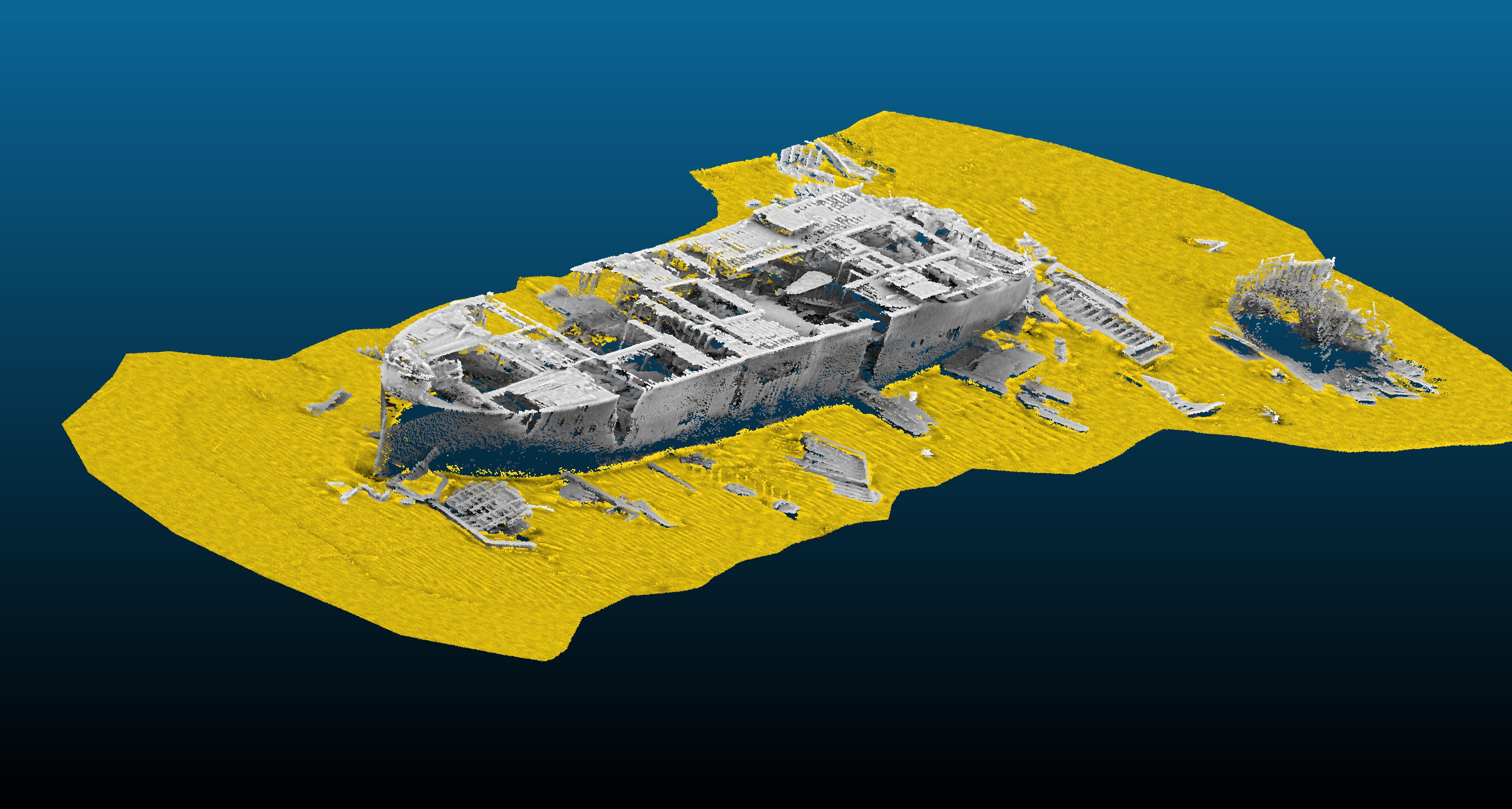
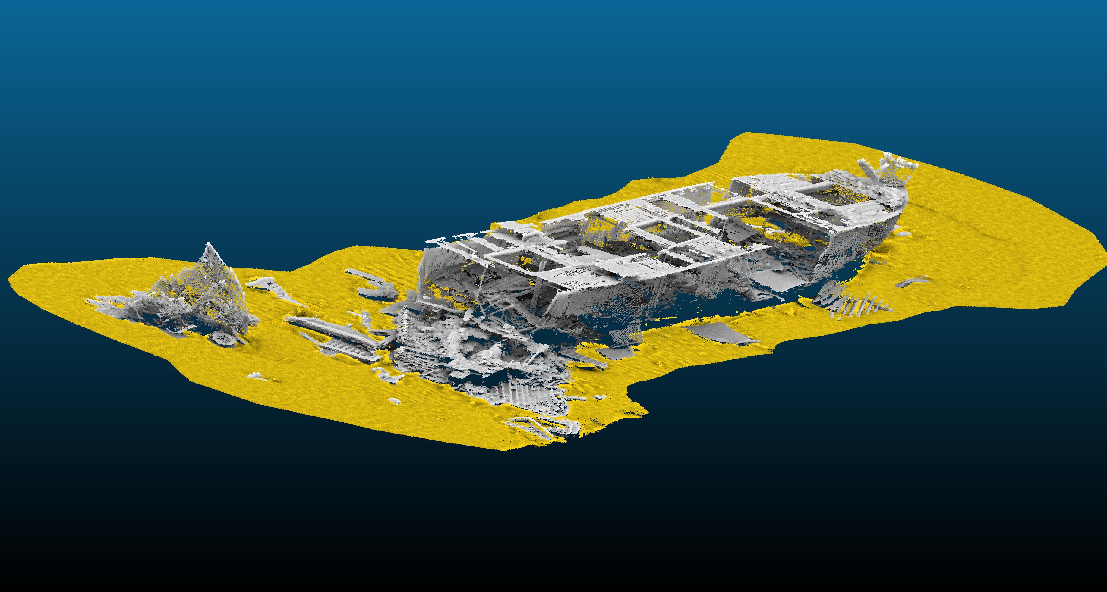
The final wreck that day is that of U-322. Having fatally damaged the two cargo vessels, she was not long after sunk by one of the convoy escorts, HMCS Calgary, a Canadian Flower-class corvette, using depth charges. She went down on 29 December 1944 in the English Channel south of Weymouth. Fifty-two men died; there were no survivors.

The wreck was identified as U-322 by Axel Niestlé after it had been initially thought that it was U-772. [15] She is recorded by UKHO as intact with extended mast, 59m long x 18m wide at a depth of approximately 42m. [16]

The wreck of the U-322 is part of a distribution of archaeological remains telling the story of one series of attacks by a submarine in WW2.

It illustrates the complications of recording and interpreting the submerged remains with a story of partial sinking, conflicting records, misidentification, salvage, clearance for navigational safety and erasure by development.

Footnotes

[1] uboat.net https://uboat.net/boats/u322.htm

[2] MKS Convoy Series, Arnold Hague Convoy Database, http://convoyweb.org.uk/mks/index.html

[3] Uboat.net, SS Dumfries, https://uboat.net/allies/merchants/ship/3396.html 

[4] Historic England, NMHR Ref No. 1246514 – record accessed via the Heritage Gateway

[5] Wrecksite, SS Dumfries, https://www.wrecksite.eu/wreck.aspx?4651

[6] See note [3]

[7] UKHO Wreck Record 18917 (Dumfries)

[8] Convoy route TBC, https://uboat.net/ops/convoys/routes.php?route=TBC; TBC-21 http://www.convoyweb.org.uk/hague/index.html

[9] Arthur Sewall, https://uboat.net/allies/merchants/ship/3405.html 

[10] https://uboat.net/allies/merchants/ship/3405.html and https://uboat.net/allies/merchants/ship/3406.html; https://www.wrecksite.eu/wreck.aspx?78432

[11] Skindeepdiving, Black Hawk

[12] https://uboat.net/allies/merchants/ship/3406.html

[13] UKHO Wreck Report No. 18557 [stern]; UKHO Wreck Report No. 18677 [bow]

[14] See note [11]

[15] https://uboat.net/boats/u322.htm

[16] UKHO Wreck Report 18541

Diary of the War – August 1944

Modern colour photograph using time-lapse photography of a concrete hard standing with side features as a mock-up of the open ramp of a landing craft. It is set in grassy dunes with grass growing in the crevices between the concrete slabs.  

The concrete 'landing craft' is shown at twilight with the time-lapse photography showing the movement of stars in the sky, to illustrate the time that has elapsed since it was built and had a function.
Replica landing craft in concrete in the dunes at Braunton Burrows, North Devon, seen at twilight, 2019. These features were used as training facilities for embarkation and disembarkation practice in preparation for the Normandy landings, and are listed as a group of eight at Grade II.
DP248202 © Historic England Archive

The Ongoing Support of the Normandy Invasion

D-Day was one day in history. It finally marked the day that the war turned, in Churchill’s famous phrase, from the ‘end of the beginning’ to the ‘beginning of the end.’ [1] As an equally famous saying has it, ‘Rome wasn’t built in a day’, and it would take some months before the Allies were able to encircle the Germans at the Falaise Pocket [12 to 21 August 1944] south of Caen and the Normandy landing beaches, to clear the way to Paris, liberated shortly after [19 August to 25 August 1944]. It would take until the end of the war to fully drive the occupiers out of France.

The ongoing invasion effort required ongoing logistical support. Resistance came not only from land forces but also from seaborne forces, so for this entry we take a look at a number of ships wrecked while supporting operations in France, the common theme of the wrecks this month.

It is a tale of landing craft, Liberty ships, and ‘Government stores’.

The first of this group were lost on 8 August when convoy EBC 66 [Bristol Channel to France] was attacked while bound from Barry for Seine Bay. EBC 66 was a multinational convoy comprising British, American, Norwegian and Dutch ships, and escorted by three Flower-class corvettes from different forces: HMS Petunia; ex-HMS Lotus loaned to the Free French as Commandant d’Estienne d’Orves, named after a French naval officer executed by the Nazis in 1941, and HMCS Regina of the Royal Canadian Navy.

Simple modern colour digital photograph of the land silhouetted in black to foreground (rocks) and right (cliffs) of image, with the white lighthouse and its light appearing to right background. The blue sea comes in from the left background to right foreground, and dark clouds are visible in the dark blue sky.
View looking north across Stinking Cove towards Trevose Head lighthouse at midnight, 2023.
DP 437442 © Historic England Archive

Off Trevose Head, north Cornwall, U-667 struck among the convoy. First to be attacked was the American Liberty Ship Ezra Weston, laden with ‘Government’ and general cargo, specified as 20mm guns, acid and military vehicles, from Avonmouth for Falmouth and the invasion beaches, which was torpedoed below the waterline at around 7.30 in the evening. This attack was initially attributed to a mine. Her captain attempted to beach her but she was in a sinking condition and beginning to break up. She broke in two at 9.45pm and had to be abandoned, fortunately without loss of life. LCT 644 took off the majority of the crew, 4 officers later leaving the vessel in a lifeboat. [2]

HMCS Regina stayed nearby to ‘become a sitting duck for the next torpedo’, as survivors put it. [3] She was struck at 10.48pm, and though 30 men were lost in the engine and boiler room, the survivors owed their lives two factors: to the Ezra Weston, as most were on deck watching over the stricken merchant in their care, and to the crewman on watch who had had the foresight to order her depth charges to be made safe. The survivors were picked up by LCT 644 and the Admiralty Trawler Jacques Morgand (formerly a Dieppe trawler and seized at Falmouth in July 1940). [4]

The two ships lie virtually side by side off the coast of Cornwall, within a few hundred metres of each other, and Regina showing evidence of an implosion on the seabed after her rapid sinking in less than half a minute, with a debris trail of unexploded depth charges. The Ezra Weston is split in two.

Historic colour photo of ship in starboard bow view, painted white, green and blue in dazzle camouflage, with spray at the bows as she cuts through the water under a blue sky with multiple white clouds on a fair day at sea. The paint is battered in places illustrating her hard work at sea in wartime.
Photo: Corvette HMCS Regina pennant number K234
© Government of Canada. Reproduced with the permission of Library and Archives Canada (2024).
Source: Library and Archives Canada/Department of National Defence fonds/e010777224

On the same day Fort Yale, a vessel on Lend-Lease to the UK from the US, was mined and damaged onthe other side of the Channel at Arromanches while on convoy ETM 56 (Southend to Seine Bay, motor transport to France) having been on ‘Special Services’ shuttling between the Thames and the Seine since the early days of the Normandy invasion. She was released from service on 12 August with engine damage, but apparently still afloat. On 15 August any further service was deferred pending repairs, but she was able to proceed back to Southend from the Seine under tow of two tugs, one British and one American, on 19 August. [5]

On 23 August she was torpedoed in mid-Channel SE of the Isle of Wight, with the majority of the crew being picked up and landed at Portsmouth.

On 14 August a near carbon-copy of the attack on Ezra Weston and HMCS Regina in roughly the same area, off Hartland Point this time, dispatched the American LST 921 and British LCI(L) 99, respectively a Landing Ship Tank and a Landing Craft Infantry (Large). They too were on an EBC convoy, EBC 72, and that number shows the frequency of convoys bound for Normandy: daily increments since EBC 66 on 8 August. [6] Their attacker was also U-667, which would herself not last much longer: her last known radio contact was on 25 August, but she failed to arrive at the rendezvous point the following day, having been lost in a British minefield off La Rochelle. [7]

Historic black & white photo of LCI(L) seen in starboard view on the water against a backdrop of hills. Seagulls circle the ship while a barrage balloon flies overhead.
LCI(L) 98 (OPS 41), seen while underway in home waters. Copyright: © IWM. Original Source: http://www.iwm.org.uk/collections/item/object/205200182

We return now to another Southend to Seine Bay convoy, this time ETC 72, a coastal convoy. On 19 August they were in mid-Channel when U-413 torpedoed Saint Enogat SE of St. Catherine’s Point, Isle of Wight. Most of the personnel survived to be picked up and landed at Juno Beach. In a strange way, her place of loss reflects her service career. Built as part of War Standard tonnage in 1918 as War Clarion, she was sold post-war to one of the French railway companies: her new name Saint Enogat reflected the Breton area served by her new owner, the Chemins de fer de l’État, but she passed in 1920 to the Société Maritime Nationale. [8]

Historic colour poster in mid-century style showing a black and white ferry crossing Dieppe harbour dotted with fishing craft seen against a backdrop of cliffs with a church on top. There are strong colours of blue (sea and sky) and orange (cliffs, reflections on the sea) to evoke warm sunny days. The text below advertises the ferry service in French.
Poster by René Péan for the Chemins de fer de l’État linking Paris & London via Newhaven & Dieppe
© The Board of Trustees of The Science Museum, London / National Railway Museum York

https://collection.sciencemuseumgroup.org.uk/objects/co229706/chemins-de-fer-de-letat-et-de-brighton CC-BY-SA-4.0

After the fall of France in 1940, Saint Enogat was seized at Plymouth and was transferred to the Ministry of War Transport (MOWT). She would return to France on the ‘Store Transport Service’ following the Normandy invasion, regularly shuttling between Southend and the invasion beaches, until her loss. Her sinking was initially attributed to a mine, but a later note adds: ‘Considered vessel more probably torpedoed by s/m.’ [9]

Our final and most famous wreck of the vessels bound for Normandy during August 1944 is undoubtedly the Liberty Ship Richard Montgomery, wrecked the following day on 20 August and regularly making headlines since.

Unlike the others, however, she was not lost to war causes. She crossed the Atlantic as part of convoy HX 301 from New York for Liverpool, arriving in Oban on 8 August, thence joining convoy ‘northabout’ round Scotland, after which she fed into a southbound convoy bound for the Thames. She then anchored in the Thames Estuary on Sheerness Middle Sand to await yet another convoy for her final destination of Cherbourg to support the invasion with her cargo of munitions.

There she broke her back and started to settle into the sand, with only half her cargo salvageable. She is designated under Section 2 of the Protection of Wrecks Act 1973 as a dangerous wreck, administered by the Maritime and Coastguard Agency through the Receiver of Wreck. [11] She lies within a well-demarcated exclusion zone and it has often been said that no other ship can now run onto Sheerness Middle Sand because of her, a most unusual case of one maritime hazard replacing the previous hazard at that location. [12]

Her story, from her background to her modern-day management, can be read in full in a dedicated article on GOV.UK

Wreck of the SS Richard Montgomery, off Sheerness, showing her upperworks and looking towards the resort of Southend-on-Sea across the Thames.
The superstructure of Richard Montgomery on Sheerness Middle Sand, Thames Estuary, seen here attracting numerous cormorants in 2014.
© Christine Matthews CC-BY-SA 2.0
https://www.geograph.org.uk/photo/4194776

Famous in her own right, the Richard Montgomery is nevertheless part of a wider story, a bigger picture, and a maritime landscape of war that fed into the continuing battle to liberate France after D-Day.

Footnotes

[1] Winston Churchill, Prime Minister’s Address to the Lord Mayor’s Banquet, Mansion House, 10 November 1942

[2] Ezra Weston, Historic England, National Marine Heritage Record (NMHR) record 766919

[3] Quoted from Deep Wreck Mysteries: Fatal Decision, broadcast ITV West, 25 January 2007, 7.30pm

[4] HMCS Regina, Historic England, NMHR record 1102944; Jacques Morgand, photograph and details online

[5] Fort Yale, Historic England, NMHR record 766513; Shipping Movement Record card, BT 389/13/246, The National Archives, Kew; Report of Total Loss, Casualty &c. No.75,092 Fort Yale, Lloyd’s Register Foundation Archive & Library, LRF-PUN-W244-0106-W,

[6] LST 921 Historic England, NMHR record 1534459; LCI(L) 99, NMHR record 1534460; convoyweb

[7] U-667, uboat.net

[8] Saint Enogat Historic England, NMHR record 1246470; uboat.net

[9] Shipping Movement record card, St Enogat [sic] BT 389/28/120, The National Archives, Kew

[10] Richard Montgomery Historic England, NMHR record, 904735; convoyweb

[11] Statutory Instrument 1973 No.1690 Protection of Wrecks (Designation No.2) Order 1973

[12] Cant, S 2013 England’s Shipwreck Heritage: from logboats to U-boats (Swindon: English Heritage)

Diary of the War – June 1944

D-Day 80

Modern colour photograph of the ends of two concrete Mulberry Harbour structures at sea, exposing their respective staircases, with a ship visible in the gap between them.
Two Phoenix caisson components for a Mulberry Harbour can still be seen at Portland, Dorset, where they were towed post-war. Listed Grade II
© Des Blenkinsopp 2019 CC-BY-SA 2.0 https://www.geograph.org.uk/photo/6173674

Eighty years on from the launch of Operation Neptune on 6 June 1944, the largest seaborne invasion in history, we take a look at those craft which, for one reason or another, did not make it to the landing beaches of Normandy, but which do form part of a tangible heritage of D-Day around the southern coasts of England.

An invasion of this scale required considerable preparations, in assembling the fleet, in meeting the conditions they were likely to find geographically and militarily, and in meeting the needs of the invasion forces once the assault on Normandy began in earnest.

A key problem for the invasion forces was the issue of landing supplies in a hostile environment until French ports could be recaptured from the occupying forces. To overcome this problem, the ‘Mulberry Harbours’ were prefabricated concrete units to be towed across the Channel and assembled at Omaha and Gold, two of the five designated landing beaches. ‘Phoenix’ caissons were built to be sunk in great secrecy off the southern coasts of England to be refloated and towed across once the invasion was under way to build the Mulberry Harbours, supported by subsidiary units such as ‘Whale’ pontoons.

Not all of the Phoenix caissons could be refloated to serve their purpose, and a number of these survive at the spot they were sunk 80 years ago. They are charted in southern English waters from the Bristol Channel in the west via the English Channel facing the Normandy coast to the Thames Estuary in the east. The remains of these Phoenix units form a counterpart to the remains of the ‘as built’ Mulberry Harbours on the opposite side of the Channel. (The Portland caissons shown at the top of the blog are slightly different, in that they came back as part of a return group post-war.)

Modern colour photograph: aerial view of two sunken caissons just visible to centre right, emerging from a large expanse of murky grey-green water. A small beacon lies atop one, marking them out as a navigational hazard.
Aerial view of sunken Mulberry Harbour caissons in the Thames Estuary, off Southend-on-Sea, Essex.
© Simon Tomson 2022 CC-BY-SA 2.0 https://www.geograph.org.uk/photo/7244874
Modern colour photograph of 8 sections of Mulberry Harbour in a bright blue sea, in various states of decay and angles from each other, no longer a coherent harbour assemblage.
Remains of the Mulberry Harbour at Arromanches-les-Bains, Normandy.
By Хрюша – Own work, CC BY-SA 3.0 https://commons.wikimedia.org/w/index.php?curid=4770875

The invasion began during the night of 5-6 June. LCT(A) 2428 was a Mk V Landing Craft Tank (Armoured), which, as the description implies, was intended to carry tanks which could roll off directly onto the beach to provide covering firepower. This function would itself attract fierce return fire, so to that end the vessel was fitted with protective armour plating, hence the (Armoured) suffix.

Contemporary monochrome pen and ink drawing seen from the bridge of a landing craft under way, with the ramp being unloaded and tanks being readied for departure as the craft nears land in the distance.
A Landing Craft Tank at sea, 1944 (Art.IWM ART LD 4180) Edward Ernest James, 1944
Copyright: © IWM. Original Source: http://www.iwm.org.uk/collections/item/object/14233

LCT(A) 2428 was laden with Centaur CS IV tanks and Caterpillar D7 armoured bulldozers as she began to make her way over to Normandy. In the early evening of 5 June she broke down and anchored near the Nab Tower, to the east of the Isle of Wight. The vessel began to capsize following damage ‘sustained by weather to double bottoms on starboard side aft’ according to a military report, and shed her lading, although fortunately without loss of life. However, she remained afloat after capsizing, posing a navigational hazard, and the only remedy was to sink her by gunfire.

LCT(A) 2428 therefore lies some distance from her cargo of tanks and bulldozers, which now lie as an assemblage off Selsey Bill, Sussex – two wreck sites from one event. The remains of the tanks and bulldozers form a Scheduled Monument: read more about the scheduled site and discover more about the Landing Craft 2428 project.

Contemporary black & white photograph of a landing craft tank, ramp down, to left, temporary harbour infrastructure to right, and in the right distance, a steamer waiting offshore.
LCT Mk V 2291 (FL 7138), similar to LCT(A) 2428 but without the armour plating, discharging a bulldozer into a Landing Ship Dock. Copyright: © IWM. Original Source: http://www.iwm.org.uk/collections/item/object/205120579

An operation at the scale of Neptune required air cover and air support. The wooden Horsa glider, a personnel carrier which could be towed to deploy troops by air, came into its own in seaborne invasions on D-Day and in other theatres of war. Like the Landing Craft Tanks, some of the gliders moved off for their own specific operations on the night of 5 June 1944, while others took to the air during D-Day itself.

Among them was Horsa Mk I LH550, bound for Landing Zone N at Ranville, Normandy, which slipped tow for reasons unknown, and ditched into the sea off Worthing, West Sussex, apparently without loss of life. Unlike the Mulberry remains or LCT(A) 2428 and her cargo, the last resting place of Horsa LH550 is unknown.

Contemporary watercolour sketch of grey aircraft, cockpit facing to the left of image, the fuselage broken at right, with its tail propped up against the wing. The wing has black and white invasion stripes.
A Horsa glider lying in a field with the rear end and tail fin resting against the left wing, giving some idea of how the Horsa wrecked off Worthing might have appeared, although in fact the rear compartment was intended to be broken off on landing:
preparatory sketch for ‘Crashed Gliders: the landing zone at Ranville, 1944’
(Art.IWM ART LD 6322) Albert Richards Copyright: © IWM. Original Source: http://www.iwm.org.uk/collections/item/object/22870

Convoy ETM-1, comprising American Liberty ships, sent to Britain under the Lend-Lease programme, and their escorts, left the Thames Estuary on the morning of D-Day en route to Normandy. The convoy moved south towards the Straits of Dover when one of their number, the Sambut, was struck by fire from German positions at Cap Gris Nez. War matériel by its very nature is usually hazardous, and cargo vessels laden with such dangerous cargoes extremely vulnerable. Sambut‘s cargo of petrol cans and vehicles caught fire, which led to an explosion of the gelignite she also carried, and it was impossible to save the ship, her crucial supplies, or, unfortunately, a quarter of the personnel on board. (Read our D-Day 70 blog for more detail on the loss of Sambut.) The loss of Sambut was captured on film in real time by another ship in the same convoy, and the reminiscences of a survivor of the 92nd Light Anti-Aircraft Regiment of the Royal Artillery who was on board, recorded 50 years after the event, are also in the collections of the Imperial War Museum (Reel 2, 05:50 onwards). It is a well-documented wreck and is known and charted.

In the breadth and diversity of the craft that were lost on 6 June 1944 within English waters – aircraft, land vehicles, cargo ships and floating harbour structures – we glimpse a little of the scale of the invasion. We recognise, too, the archaeological remains of a single day in history on this side of the Channel, linked to their counterparts lost the same day on the Normandy beaches, memorials in concrete, wood, and steel.

No.79 James Eagan Layne

In this week’s post, we commemorate the loss of the US Liberty Ship James Eagan Layne 70 years ago on 21 March 1945, torpedoed while bound from New Orleans, last from Barry in Wales, for Ghent with what was then termed ‘Government stores’. Translated, that meant military vehicles and other war materials destined for the liberation of Europe as the war was drawing to a close. Historic recoveries from this vessel have included numerous shell cases. (1)

The forward section of the James Eagan Layne wreck, using modern bathymetric imagery allowing a view into the ship
Forward section of the James Eagan Layne, by courtesy of MSDS Marine and Swathe Services. There is much scattered debris, evidence of extensive post-war salvage.

The James Eagan Layne was one of several Liberty ships and other vessels bound for Belgium in the spring of 1945, following the successful conclusion of the Battle of the Bulge in January 1945. The Allies had repulsed the German advance, or ‘bulge’ in their lines, with heavy loss of life, particularly among the US troops who bore the brunt of the fighting. Allied access to the Belgian ports was now secured, barring minefields and U-boats, resuming the communication links severed by the fall of Belgium in 1940.

The pattern of wrecks on the seabed mirrors the fate of those communication links. Ten ships, bound either to or from Belgian ports, were sunk in English waters following the declaration of war in September 1939. It was a similar figure in early 1940 prior to the fall of Belgium in May, with 11 ships sunk by mine or torpedo on the same route.

The aft section of the James Eagan Layne wreck, using modern bathymetric imagery allowing a view into the ship, and showing scattered debris
Aft section of the James Eagan Layne, by courtesy of MSDS Marine and Swathe Services. This image allows an insight into the box-like construction characteristic of the Liberty Ship.

Transport links with occupied Belgium were then severed and are reflected in the lack of corresponding wrecks from late 1940 to early 1945: then, as Allied ships were once more able to reach Antwerp and other ports, there was also a recurrence of wreck events. Between January and May 1945, 10 ships are known to have been sunk in English waters en route to or from Belgium: they included other Liberty Ships, the Henry B Plant and the James Harrod. The John R Park was also torpedoed the same day as the James Eagan Layne, albeit on a different route, bound from England for the United States.

For more on the James Eagan Layne, please have a look at the dedicated SHIPS (Shipwrecks and History in Plymouth Sound) and Promare Liberty 70 site.

(1) Receiver of Wreck droits.

With many thanks to MSDS Marine and Swathe Services for permission to reproduce these beautiful images.

No.55: Sambut

Two sections of Mulberry Harbour used for the D-Day landings of 1944 and relocated to Portland Harbour in 1946. Listed Grade I
Old and new: Two sections of Mulberry Harbour used for the D-Day landings of 1944 and relocated to Portland Harbour in 1946, as seen from Portland Castle. Listed Grade II. (Image courtesy of Andrew Wyngard)

D-Day

[This blog entry was originally written to commemorate the 70th anniversary of D-Day, 6 June 2014, and has been updated for the 75th anniversary, 6 June 2019.]

Today, on 6 June, I would like to turn my attention to a wreck which took place shortly after noon on 6 June 1944.

Although the south coast was the prime departure location for D-Day, it’s important to remember that other ports also contributed to the huge invasion effort with ships, men and materials crossing the Channel from other ports. Air cover and support operations for Normandy also took place from airfields that were not necessarily the closest to the invasion sites, such as RAF Rivenhall/USAAF Station AAF-168.

The Thames was another focal point of activity in the run-up to the Normandy landings and beyond. For example, in the run-up to D-Day aircraft struck at the Pas-de-Calais, drawing enemy attention away from the actual invasion site, as part of Operation Fortitude, a co-ordinated deception operation. The Thames also played its part on D-Day itself.

On D-Day -3, 3 June 1944, troops had embarked on SS Sambut in London, including members of the 92nd Light Anti-Aircraft Regiment of the Royal Artillery. (1) It was common during wartime for embarkation to take place several days beforehand and there were cases later in 1944 when troops ‘swung at anchor at Glasgow in the murk for five days before we finally set sail.’ (2) On 6 June 1944 convoy ETM-1 left Southend under the command of Captain Willis, bound for Normandy, composed principally of escorts and American Liberty ships loaned to Britain under the Lend-Lease programme, Sambut sailing with her sisters Samark, Samarovsk, Sambut, Samdel, Saminver, Sammont, Samneva, Samos, Sampep, Samphill, Samvern, and Samzona, (3) carrying troops, vehicles, and ammunition. Cargo was stowed inside other cargo to maximise space: lorries were filled with motorbikes in some cases, gelignite in others.

Unfortunately, shells fired at random from German gun batteries on the Calais side struck the Sambut off Dover at 1215. Lorries and petrol cans on deck caught fire, followed by a gelignite explosion in the hold. The troops tried to jettison some of the munitions but it was quickly realised that it was a futile effort. Within 15 minutes the order was given to abandon ship, and by 1245 the ship had been completely abandoned, although not without the loss of 136 crew and military personnel out of 625 (562 military/63 crew) on board. (4)

She was the first Liberty ship to be lost in Operation Overlord, half way through D-Day itself: other Liberty ships would follow as the Normandy campaign wore on over the ensuing weeks and months, such as the well-known Richard Montgomery, also off Southend, in August 1944.

The Sambut shares several features in common with other 20th century wartime wrecks. Primarily, of course, her combustible cargoes contributed to her loss, but blazing wrecks in navigational channels were also a danger to other shipping, and this hazard was compounded under wartime conditions by their potential to direct enemy attention towards operations.

Her master had been ordered to lower the ship’s barrage balloon to make the vessel less conspicuous against the white cliffs of Dover, but it was already too late: either the ship had already been spotted or the barrage from the shore had managed to score a lucky hit.

As with the War Knight off the Isle of Wight in 1918, so with the Sambut in the Straits of Dover in 1944: the burning ship was scuttled by her own side, as the Royal Navy fired a torpedo to finally sink her. (5)

One other feature of 20th century wrecks, as we have often recorded in this blog (for example, the Ballarat, 1917) is that they tend to be well-documented by ‘real-time’ evidence in a way that was not possible before the advent of photography, and of course it then became critical to document operations as they unfolded, for both record and propaganda purposes. This moving film in the IWM Collections records a church service aboard Samarovsk followed by a view of the Sambut on fire, with explosions visible at intervals.

At one and the same time the vessel is characteristic of the archaeological remains of 20th century conflict around the English coastline, and a unique reminder of a specific day which turned the tide of the war.  Today she lies intact and upright on the seabed, a tangible reminder of 6 June 1944.

(1) William Wills, “92 LAA Regt. Loss of the Sambut on D-Day“, BBC People’s War archive, 10 July 2005

(2) Oral history reminiscence, Corporal Cant RAF, Convoy KMF 36, November 6, 1944

(3) Convoy ETM-1, Arnold Hague Convoy Database

(4) Tom McCarthy, True Loyals: A History of 7th Battalion, The Loyal Regiment (North Lancashire/92nd (Loyals) Light Anti-Aircraft Regiment, Royal Artillery, 1940-1946, 2nd ed., Countyvise Editions Ltd., Birkenhead, 2012, republished online

(5) ibid.

(6) UKHO 13665