In early 1944 Britain was watching and waiting. ‘Lorries and tanks kept rumbling towards the south coast, so we knew something was going to happen,’ in the words of Corporal Cant, based at RAF Ford, Sussex, describing the later spring of 1944. ‘Nobody said anything about it. But more and more of them were building up. We saw, and we knew, but we didn’t know when, and we didn’t talk about it.’
There is something of that sense of anticipation in the wreck highlighted for February 1944, LCI(S)511, Landing Craft Infantry (Small) 511, on the Channel coast facing a France that soon would be the focus of a liberation effort by just such craft. With the benefit of historical hindsight, we can say ‘soon’, but at the time it must have felt that ‘soon’ would never come: scenes such as the one below, in the countdown to D-Day, were months away.
All anyone could do was watch, wait, and play their part: and only those ‘in the know’ had an overview of what was happening behind the scenes. An initial joint plan, i.e. a combined Allied plan, was issued on 1 February for the invasion, with the naval outline plan following later that month. [2]
The Landing Craft Infantry (Small), LCI(S) for short, were built 1942-3 with bullet-proof armour plating over a wooden hull structure designed by the Fairmile Marine boatbuilding company, which specialised in motor boats (the company grew out of motor manufacture). The ‘Fairmile H’ design of the LCI(S) was produced in kit form and outsourced to other small boatbuilding firms for assembly, such as Leo Robinson at Oulton Broad, Suffolk, who built LCI(S)511 and LCI(S)533. [Explore Robinson’s yard in this historic image.] Others were built on Oulton Broad by Collins and Brook Marine, and production was dispersed countrywide, both because of the small scales of the yards and for security reasons. At 110 tons, 105 feet long x 22 feet wide, they were intended to carry a complement of around 100 men (descriptions vary from 96 to 102 troops). [3]
At the same time operational bases came into being in the run-up to D-Day. From 1942 the Southwick Ship Canal on the Sussex coast between Shoreham-by-Sea and Portslade became a Combined Operations Landing Craft Base, known as the ‘stone frigate’ HMS Lizard. HMS Lizard was further developed in 1943 and by January 1944 was ‘very busy’ with both large and small landing craft. Lizard‘s vessels and personnel are known to have participated in exercises over February 1944. [4]
The former river channel of the Adur was canalised to provide a harbour free from the natural silt deposit processes that were otherwise threatening to clog up the harbour mouth. It runs parallel to the seashore, with the river and harbour mouth further west, and sloping shingle beaches on the seaward side.
As a ship canal for both smaller and larger vessels, landing craft could be virtually hidden in plain sight, and as a USAAF air photo from April 1944 in Historic England’s collections shows, it would all appear quite innocuous, with existing buildings requisitioned to form the base, and a natural gathering place for craft.
The advantages of this location as a base were a natural seaward defence with an easily controlled harbour mouth, and on the shoreward side are sloping shingle beaches, ideal for rehearsing landings.
The day after the Allies issued their joint plan on 1 February 1944, LCI(S)511 was beached at Portslade, Sussex, to become a total loss. [5] What happened there? There seems to have been nothing particularly unusual about the weather that day, with local readings recording a force 4 (‘moderate breeze’) at south-westerly and temperatures mild, between 49-53 degrees Fahrenheit, which would be recorded as 9-11 degrees Celsius today. [6]
We know of at least 74 other vessels that were lost in force 4 conditions in English waters since records of weather conditions at the time of loss began in the mid-19th century. They tend to have two broad characteristics: either something else happened to them, such as springing a leak, running aground or involvement in a collision, i.e. factors which are not weather-dependent and can be overwhelming in themselves; or they were small vessels, fishing smacks, yachts, cutters, barges, and so on, which could be quite disproportionately affected by weather conditions, depending on wind direction and their activity or lading at the time.
Records appear to be quite brief, but it is possible to read between the lines a little. The key word is that LCI(S)511 was beached. There are only two reasons for beaching vessels, i.e. to deliberately put them ashore: the first, and more benign, reason, is that they can be effectively ‘parked’, as sailing colliers once did to deliver their coal on the Sussex coast, or fishing boats can still be seen today drawn up on the foreshore in many places – and, of course, beaching was what landing craft were designed to do!
As we have seen, much of the Sussex coast, as at Portslade, comprises a gently sloping shingle shoreline, ideal for beaching vessels, and this history of safe landing grounds was what fitted Portslade and Shoreham on either side of the Adur to be a landing craft base.
However, beaching on the foreshore can leave the craft so drawn up very vulnerable if a storm subsequently ensues. In other words, they can be safely beached, then lost after beaching, but this seems unlikely in the weather conditions reported for 2 February 1944. With the beach ideal for the landing craft’s function, the design of the vessel suited for that purpose, and the base so close by, and operational and repair support therefore easily accessible, it seems surprising that LCI(S)511 became a total loss, in the brief and bald facts available to us.
So possibly something happened to LCI(S)511 thatcaused her to be beached, rather than being beached in the natural course of exercises, say. We turn now to the less benign reason for beaching vessels, which tends to happen on the nearest shore in extremis, for example having sprung a leak, taken on water, following a collision, or to avoid running onto a significant hazard nearby. In other words, something has happened to force the ship to run ashore to avoid sinking at sea.
It therefore seems plausible that something happened to LCI(S)511 at sea, possibly taking on water for some reason, or perhaps a collision, after which it proved impossible to get her into the shelter of the ship canal basin. Such an event would be natural on exercises: naval exercises ‘gone wrong’ in some way have historically caused several wrecks that are well-documented in the record, and a prior contributory factor which forced the vessel ashore seems the most plausible reason for the ensuing total loss that was reported.
The date of loss does not tally with the major exercises that were undertaken in the run-up to D-Day, but as we know that HMS Lizard was involved in exercises in February 1944, it seems reasonable to surmise that there were smaller-scale and more localised exercises that fed into major rehearsals as preparations for the invasion gathered pace.
Thus LCI(S)511 has the potential to combine both broad characteristics of vessels lost in force 4 conditions: a hint of a prior background cause, not influenced by the weather, that forced her to be beached, and the relatively small size of the vessel more vulnerable to mild weather conditions once already damaged.
Epilogue: LCI(S)508 was, until recently, seen as Valeur among the houseboat community of Shoreham-by-Sea on the Adur, not far from where LCI(S)511 met her end. For more on her story, explore footnote [7].
Footnotes
[1] Cant, R, 2012 unpublished oral history reminiscence, recorded and documented by Serena Cant
[2] Naval Historical Branch (nd) Operation Neptune: The Normandy Invasion: D Day 6 June 1944 (Ministry of Defence: published online)
[3] Slee, G 2000- Combined Operations (published online); naval-history.net (nd) Royal Navy Vessels Lost at Sea, 1939-45 – by type: Amphibious Warfare Vessels (published online), based on HMSO British Vessels Lost at Sea 1914-18 and 1939-45 (London: HMSO) known as BVLS; Navypedia (nd) LCI(S) type small infantry landing craft (LCI(S)501) (1943) (published online); Wikipedia (nd) Fairmile H landing craft (published online)
[4] Royal Navy Research Archive (nd) HMS Lizard: Combined Operations Landing Craft Base (published online)
[5] BVLS, Section III, p56
[6] Met Office 1944 Daily Weather Report February 1944, 2 February 1944 (online)
[7] Spitfires of the Sea (nd) Shoreham Survivors (published online); O’Sullivan, T 2021 ‘Tales from the Riverbank’, Beach News: the magazine of Shoreham Beach Residents’ Association, Summer 2021 issue (online)
The SS Solstad – a Swedish ship torpedoed in Convoy WP 457
It’s hardly attention-grabbing to summarise the facts of a ship’s loss in the headline title. But the more you look at it, the more there is in those bald facts that piques curiosity.
Wasn’t Sweden neutral in the Second World War? Why was a ship from a neutral nation torpedoed? (Neutrals were never immune to loss from war causes: often mines, which struck indiscriminately, but our records show that they were often torpedo targets, too.) What, in fact, was a ship from a neutral country doing in a British-led convoy wholly within British waters voyaging from one British port to another?
The Loss Event
The convoy prefix WP indicates Wales to Portsmouth. On 2 January 1944 the MV Underwood left Liverpool, arriving 3 January at Milford Haven. That day the MV Polperrosailed from Ellesmere Port for Milford Haven, arriving 4 January; at the same time the SSSolstad left Swansea for Milford Haven. On 5 January the assembled convoy finally put to sea from Milford Haven for Portsmouth with their escorts, including the destroyer HMS Mackay and the Isles-class naval trawler (i.e. a purpose-built Admiralty trawler, rather than a requisitioned fishing vessel) HMT Wallasea. [1]
The convoy rounded Cape Cornwall and Land’s End and on 6 January 1944 seven E-boats (German Schnellboote, ‘fast boats’) of the German 5th Flotilla, divided into two flanks, under the command of Kapitänleutnant Karl Muller, were lying in wait to make a surprise attack from the landward. Just before 3am that morning, they opened fire. [2] At 5.25am the ‘resident naval officer at Penzance reported that a convoy had been attacked about five miles south of Treen coastguard hut’. [3] This suggests that the report had come from the coastguard at Treen. Twenty-five minutes later Penlee’s motor lifeboat W and S was on its way in a moderate south-westerly with a rough sea out into Mount’s Bay and on into the Channel. They found two rafts at the position stated, one with two men on it, and the other ten men and two women ‘survivors from the Swedish steamer Solstad, bound with coal from Swansea to London.’
The lifeboat picked them up, ‘made a further search, and found nothing’, radioing for medical assistance shoreside on arrival at 9am. She then ‘put out again and made a further search . . . found only wreckage . . . ‘
There was no sign of the convoy. They must have long swept past, with HMS Mackay having kept the 2nd group of E-boats at bay, while the E-boats themselves were on their way back to base at Brest.
S 136and S 84 had sunk the Polperro, laden with coal, S 141 theUnderwood, carrying ‘Government stores’ on ‘Special Military Service’, i.e. war matériel, S 143 the Solstad, again with coal (1780 tons), and S 138 their escort Wallasea. There was loss of life from all four vessels: Polperro was lost with all hands; at least 13 deaths are recorded from the Underwood; and, although not everyone died aboard the Wallasea, the toll was particularly heavy, with 35 lives lost. Aboard Solstad one of those who died was a stewardess, Alide Reicher; two of the crew who died were, however, British. [4]
A mystery of location
All four are charted wrecks, but, of the group, only Underwood appears to have been positively identified from her propeller boss, approximately 4 miles NW of a cluster of sites derived from the reporting position of of 49˚ 57’N 005˚ 28’W on all three merchants’ Shipping Movement Cards. This includes the Underwood‘s own card, so she at least is not at the position reported therein. [5]HMT Wallasea does not have a Shipping Movement Card, but has also been assigned to the ‘cluster’ position. The Shipping Movement position is likely to have been reported by others in the convoy – the Trade Division Signal for the convoy reported 16 ships, so a fairly large and well spread out convoy – and is likely to be an approximation or aggregate of reported positions from the escorts and/or commodore (lead merchant). [6]
The three charted reports of Polperro, Wallasea and Solstad, clustered around those Shipping Movement Card co-ordinates are all ‘dead’ or ‘disproved’, i.e. do not represent wreck sites but are based on contemporary records, not archaeological remains. In any case, they are clustered around an approximate position, which is also somewhat at odds with the other position quoted, that attended by the RNLI, which at 5 miles south of Treen would be approximately 49˚ 57’N 005˚ 37’W.
Location map of the events of 6th January 1944, showing how the positions cited are at variance with one another: the lifeboat’s approximate voyage from Penlee to 5 miles south of Treen, where the Solstad was found, is shown. The yellow pin represents the known location of the Underwood, and the red pin the Shipping Movement Record cards’ approximate position for Polperro, Solstadand Underwood, and to which HMT Wallasea is also assigned. It has been proven inaccurate for Underwood, and in the light of the RNLI report, cannot be accurate for Solstad. The convoy direction was eastbound.
As we have observed in several of our previous blogs, it is not uncommon for wreck sites to be discovered some way from the location originally reported for all sorts of reasons, and in the case of a convoy the vessels would be dispersed over some distance. The position of Underwood is certainly 5 miles from Treen at approximately 49˚ 59’N 005˚ 31’W, but the bearing is SE of Treen, not south, and the ‘cluster’ location further away on a similar SE bearing.
When the RNLI first attended the wreck in the position given to them, 5 miles south of Treen, they found survivors from one ship, and when they returned they found wreckage, but it is not known how much of the wreckage was Solstad and which, if any, from the other ships – the RNLI report gives no further details. However, the discovery of Solstad‘s survivors suggests that the position reported to the RNLI was substantially correct, at least for that vessel. The lifeboat station at Penlee is on the western side of Mount’s Bay, and the lifeboat would have navigated southwards before rounding the coastline and bearing away to the south-west to intersect with the position given to them off Treen, with Underwood some 3 or 3.5 miles to the south-east as they moved out into the Channel, i.e. the identified position of Underwood now lies NE of the position to which they were bound.
The RNLI report does not mention any sighting of Underwood or any of the other vessels.
When they reached the scene to which they had been directed, they found only survivors from the Solstad; no other ships or survivors are reported (though there were survivors from Underwood and Wallasea, as well as Solstad, presumably picked up in convoy) so this does suggest that the other ships were, like Underwood, lost slightly outside both positions stated, i.e. the one given to the RNLI and the other reported on the Shipping Movement Cards. The loss of life, the fact that Solstad itself was not seen but rafts were, and the lack of any reported sighting of the other three by the lifeboat en route or at scene suggests that all four sank very quickly.
Can we reconstruct the convoy and the relative positions of the ships? The E-boats attacked from the landward side. Underwood at least might well have been on the port and landward flank of the convoy. As Solstad was at the position reported to the RNLI, then she was astern and to the south-west of the known position of Underwood. It is hard to see how HMS Mackayheld off further E-boat attack without being astern and to the west of the convoy, so close to Solstad, perhaps, and similarly Wallasea might have been the escort on the seaward flank.
Both the Merchant Shipping Movement Cards and the position off Treen reported to the RNLI either give or come out at the same latitude of approximately 49˚ 57’N, suggesting some accuracy at least to that half of the co-ordinates, potentially the starboard and seaward flank. It seems reasonable to suggest that the three unattributed wrecks in this convoy may therefore lie in an arc roughly bounded by the present position of Underwood to the north-east and the reported position of Solstad to the south-west.
The Solstad‘s loss report sheds no light on the matter, as it states ‘Sunk owing to war causes off South-West England about 6th January, 1944.’ [7]
Another mystery . . .
But to get back to the questions we asked at the start of the blog – what wasSolstad doing there in the first place? Why is there a neutral Swede in a British convoy? The answer lies in Sweden’s statement of neutrality on the outbreak of the Second World War, and the measures then undertaken by the Allies and other neutrals in the early years of the war both in terms of trade and any agreements made with Germany, such as transit agreements for the occupation of Norway. For example, in early 1940, even before the entry of the United States into the war, President Roosevelt prevented the export of aircraft and engines to Sweden to prevent them falling into German hands, and Britain likewise blockaded Swedish transatlantic traffic. [8]
Relations between the Allies and Sweden were therefore somewhat strained, but in April 1940 Germany blockaded the Skagerrak, the sea between Denmark, Norway and Sweden, in tandem with the invasion of Denmark and Norway – at stroke depriving Sweden of nearly 600,000 tons of shipping which could no longer return to their home ports. It was an opportunity, therefore, for the Allies to procure much-needed shipping on time charter (i.e. being leased for a fixed period of time, rather than per voyage). Here was where commerce could improve relations and diplomatic outcomes. [9]
Location map of the Skagerrak: the German blockade prevented westbound access to the North Sea and eastbound access to the Baltic. Creative Commons CC-BY-SA 3.0
The avenues open to the Allies for the ships of occupied nations did not apply in the case of neutral and unoccupied Sweden. However, commercial deals could be struck to mutual advantage: cash for Sweden, ships for Britain. Britain’s tonnage agreements with Scandinavian powers during the First World War were once more being played out in a different guise in this second conflict.
On 8 April 1940, Solstad‘s Shipping Movement card shows that she was in Burntisland, and therefore formed part of this group for which a commercial deal had been struck: although, unusually, her card shows all her movements from March 1939 onwards – before the war. Quite why has not yet been established, but it is a curious detail.
She was then allocated to the French on time charter to join a French convoy bound for the French Mediterranean port of Sète, and was ‘delivered at Methil’. After the fall of France in May 1940, Solstad was intended to return to the UK, but instead seems to have ended up in Casablanca in neutral Morocco, at that time a French colony under the control of the Vichy government. Thence she made her way to Barcelona, where her French time charter was transferred to Britain’s Ministry of War Transport (MOWT) from 20 July 1940.
Thereafter she worked UK to Spain and Portugal, both of which were also neutral, albeit under Fascist regimes: trade remained possible, albeit overshadowed by war. An Allied oil embargo aimed to prevent Spain joining the war on the Axis side, while Portugal preserved the ancient Anglo-Portuguese alliance and relations with Spain by remaining neutral without ever formally declaring neutrality. [10]
During this period of operations Solstad was sub-contracted to Welsh coal firms for iron pyrites. [11] Anglo-Iberian trade in the Second World War is not readily legible in archaeological remains in English waters, except for a handful of wrecks from the early years of the war. This history remains somewhat obscure from both the archaeological and documentary points of view, so there is little comparable context for the Solstad‘s early wartime history under MOWT. We can, however, say with certainty that the archaeological and documentary record reveals no Portuguese or Spanish wrecks in English waters during the war – unlike the pre- and post-war periods. [12]
For ships in convoy calls to other ports elsewhere on the Iberian peninsula were slated as to or from Gibraltar, somewhat obscuring their movements and trade. It is only by looking at the cargoes or the intended calling points if reported in convoy, and the Shipping Movement Cards, that slowly reveal the picture. In that regard, the convoys for HG 41 (Homeward – Gibraltar) of August 1940 and OG 73 (Outbound – Gibraltar), August-September 1941, in both of which Solstad participated, display more of the extent of the trade than the remains in English waters demonstrate. [13]
This is fairly unusual, as the numbers of wrecks for a given period and trade are usually reasonably proportionate to, or correspond well chronologically with, the ebbs and flows of that trade. [14]
Quite a few Swedish ships participated in these voyages – whether this is coincidental, as British-owned ships also made these voyages, or whether neutral ship to neutral nation voyages could facilitate matters, is an interesting question.
We know that while on time charter to the MOWT, the vessel continued in Swedish ownership and management – her Shipping Movement Card makes her nationality clear, supported by a survey report in December 1943, and her casualty report only a few weeks later, revealing that she belonged to Rederi AB Solstad in Stockholm, and the Swedish name of the company manager. [15]
After her last voyage to Spain in September 1941 to pick up iron pyrites, Solstad then made her way along the Spanish coast to join a 56-strong convoy of merchants with their escorts out of Gibraltar, departing on 2 October 1941.
She was then reassigned once more to British coastal convoys, and it was after just over two years of such duties, wholly within British waters, that she was finally sunk in January 1944.
Accounts of the loss event from several German-language sources based on primary material transcribed from E-boat logs, bring out another intriguing detail. They state that theSolstad was niederländisch or Dutch, but also state that the British Polperro was Swedish. [16] It is unclear whether there was a Dutch ship in the convoy – there may well have been, as many Dutch ships escaped, were transferred to the MOWT, and operated in British convoys – but we do not know all the ships involved in WP 457. Were nationalities simply swapped around in error at the time – which seems likely if Swedish nationality was attributed to a British vessel – or is there something more substantial behind this?
Solstad‘s history is thus peppered with slightly unusual details. It is a history which bears witness to the dance of the nations in time of war: a complex web of commerce, diplomacy, and warfare, which affected the ship’s operations and culminated in her loss.
Footnotes
[1] Registry of Shipping and Seamen: War of 1939-45: Merchant Shipping Movement Cards BT 389/42/240 Solstad (The National Archives, Kew) Catalogue entry; convoyweb
[2] Knifton, J 2015 “A very cunning Kapitän’, johnknifton.com, published online; Förderverein Museums-Schnellboot e.V. nd S-Boote in der Kriegsmarine 1935-1945: Die Kriegschauplätze der S-Boote: Englischer Kanal 1944 (in German) Förderverein Museums-Schnellboot e.V. published online
[3] RNLI, 1944 “Services by the Life-boats of the Institution, by Shore-boats and by Auxiliary Rescue-boats during 1944”, Lifeboat Magazine (RNLI: republished online)
[4] Knifton 2015; Merchant Shipping Movement Cards, Underwood, BT 389/31/3 (The National Archives, Kew); Commonwealth War Graves Commission records https://www.cwgc.org/
[5] United Kingdom Hydrographic Office: Underwood, UKHO No.22680; Polperro, UKHO No.22553; Solstad, UKHO No.22529; and HMT Wallasea, UKHO No.22549; Merchant Shipping Movement Cards, Polperro, BT 389/24/23; Solstad, BT 389/42/240, and Underwood, BT 389/31/3 (The National Archives, Kew)
[7] Lloyd’s Register Foundation Report of Total Loss, Casualty, &c. No.33528, January 1944, LRF-PUN-W217-0080-R
[8] Montgomery, V 1985 The Dynamics of British Policy towards Sweden, 1942-1945 (King’s College London: PhD thesis, online at the King’s Research Portal https://kclpure.kcl.ac.uk/portal/; Olsson, U 1977 The Creation of a Modern Arms Industry, 1939-1974 (Gothenburg: Institute of Economic History, Gothenburg University); Committee on Military Affairs, 1945 Elimination of German Resources for War, Hearings before a Subcommittee on Military Affairs, United States Senate, Part 5: Testimony of Treasury Department: July 2, 1945 (Washington: United States Government Printing Office)
[9] Montgomery 1985; Lottaz P and Ottosson I, with Edström, B 2022 Sweden, Japan and the Long Second World War 1931-1945 (London: Routledge)
[10] Rockoff, H & Caruana, L 2000 A Wolfram in Sheep’s Clothing: Economic Warfare in Spain and Portugal, 1940-1944, Working Paper, No.2000-08 (Rutgers University, Department of Economics, New Brunswick, NJ) doi: http://hdl.handle.net/10419/94297; Leite, J da Costa 1998 “Neutrality by Agreement: Portugal and the British Alliance in World War II” American University Law Review, Vol. 14, No.1 (1998): 185-199 Digital Commons; Trowbridge, B 2016 “History’s Unparalleled Alliance: the Anglo-Portuguese Treaty of Windsor, 9th May 1386”, gov.uk blog published online. There is other evidence of Portuguese help, or at least friendly neutrality, during the war: for example, Convoy OG 91 [Outbound – Gibraltar] in 1941 took refuge at Lisbon following an attack in the Atlantic.
[11]Registry of Shipping and Seamen: War of 1939-45: Merchant Shipping Movement Cards BT 389/42/240 Solstad (The National Archives, Kew)
[15] Lloyd’s Register Foundation, Report of Survey for Repairs &c. No.54854, Solstad, December 1943, LRF-PUN-W217-0082-R; Report of Total Loss, Casualty, &c. No.33528, January 1944, LRF-PUN-W217-0080-R
[16] Dutch nationality attributed to Solstad in Chronik des Seekrieges 1939-1945 Januar 1944 (Württembergische Landesbibliothek: published online) (in German) and Lebenslauf S-143 (Historisches Marinearchiv; published online) (in German); although Förderverein Museums-Schnellboot e.V. (published online: in German) correctly attributes Swedish nationality to the Solstad.
21st December 2023 marks the 80th anniversary of the loss of Chasseur 5/Carentan named after the port of Carentan on the Cotentin peninsula in Normandy. She was one of a number of French chasseurs sous-marins or submarine hunters ordered in 1937 and which entered service in the French Navy in 1940. [Images Défense gallery of official photographs of Chasseur 5 taken in early 1940 including remarkable views of a seaplane under tow.]
Along with Chasseurs 6 and 7, 9-11, 41 and 42, Chasseur 5 took part in Operation Dynamo, the evacuation of Dunkirk, over May-June 1940. [1] Sixteen Chasseur-class vessels were then stationed in Britain and entered the service of the Royal Navy as fast patrol and escort vessels. Although Chasseurs 6 and 7 were sunk off St. Alban’s Head under the White Ensign in October 1940, as early as July 1940 the Chasseurs began to be turned over to the Free French Navy (FNFL) and to be renamed in FNFL service after French coastal towns. For example, Chasseur 8 re-entered service under the FNFL in April 1941 as Rennes, to be attacked and sunk off the Lizard in one of the ‘tip and run’ raids of July 1942. [2]
Chasseur 5 was similarly renamed Carentan, but in most British records seems to have kept the designation Chasseur 5 with no real consistency over the nomenclature, including HMS Chasseur 5, while French records similarly note the vessel as Chasseur 5“Carentan”. [3] There is likewise some confusion over when the vessels actually entered Free French service, for example the July 1940 date, or, as some French sources state, in 1943 – the latter following a refit at Marvin’s (Coles) Yard, Cowes, Isle of Wight, where the Free French Chasseurs were stationed from 1940-1945, commanded by the 1st Destroyer Flotilla. The earlier date of 1940 seems more likely given the fact that they were assigned a base at Cowes from 1940, and named as the Chasseur Flotilla of French ships there in January 1942, including Carentan (Ch. 5). [4]
Contemporary aerial view taken on 21 June 1942 at the time Marvin’s Yard was in use as the Free French Chasseur base – seen on the west (upper bank in this view) at the entrance to Cowes. RAF_HLA_623_V_6089 Source: Historic England Archive (RAF Photography)
As thewar memorial to the Free French Submarine Chasers on the Isle of Wight states, in a bilingual inscription: ‘They were in the fighting line in the Channel, notably in the Cowes blitz, Bruneval and Dieppe raids, Liberation of France.’ [The Cowes blitz took place in May 1942.]
On 21 December 1943 Chasseur 5/Carentan, under Lieutenant de vaisseau Michel Pierre Sauvage, alias Sampson, was assigned to escort HMS Rorqual, a minelaying submarine of the Grampus class which were all named after sea creatures, from Brixham to Portsmouth. As they passed St. Alban’s Head that morning, the sea conditions deteriorated to force 7 (some sources state a SW force 9 gale) and when a huge wave struck her, she capsized.
Contemporary RNLI records state that a ‘strong and increasing south-west wind was blowing, with a heavy sea, and visibility was very poor at times’, while Met Office records show that conditions were consistently southerly force 5 between 0100 and 1300 that day off Portland Bill. These official observations were, however, point-in-time snapshots, and it appears likely, therefore, that the wind got up at mid-morning in the interval between the 0700 and the 1300 reports. [5]
At 10.27 the Swanage coastguard summoned the Swanage lifeboat Thomas Markby to go to the assistance of ‘an escort vessel which had capsized three miles south of Durlston Head.’ Less than 20 minutes later after the launch of the Thomas Markby, she reached what proved to be ‘Chasseur 5, a chaser of the French naval forces’. Rorqual was standing by as three men from Chasseur 5 clung to the capsized keel, and ‘it was only by skilful seamanship that they were rescued’ by the lifeboat. [5]
Rorqual then rescued four more of Chasseur 5‘s crew, but without tools the lifeboat Thomas Markby was unable to assist the remainder of the crew trapped in the vessel, who could be seen through a porthole. Thomas Markby arranged with Rorqual to ‘pump oil on the sea’, the classic ‘pouring oil on troubled waters’ to calm the sea in extremis, and returned to Swanage to land the rescued men and pick up saws and axes to break into the stricken vessel. However, on the return voyage the Thomas Markby was met with the news that Chasseur 5 had sunk with the remaining crew, three of whom were British.
The site of Chasseur 5/Carentan has been identified since the 1960s 1.75 miles SE of Anvil Point, Dorset. It is now a well broken wreck but, with the loss of life involved, it clearly remains a maritime grave with ample evidence of its military purpose, including shells and depth charges still in situ.
Footnotes
[1] Association of Dunkirk Little Ships nd “All Known Ships”, Association of Dunkirk Little Ships website
[2] Fondation de la France Libre 2022 Hommage aux Forces navales françaises libres: Ils ont rejoint la France libre dès juin 1940: Hommage aux jeunes du Guilvinec et de Treffiagat-Léchiagat qui ont refusé la défaite, Fondation de la France Libre, published online
[3]British sources: e.g. RNLI 1943; Catalogue entry for TNA Kew ADM 358/3155 Patrol Vessel Chasseur 5: 21 December 1943; capsized and sunk online, part of the ADM 358 series Casualty Branch: Enquiries into Missing Personnel, 1939-1945 War; the Commonwealth War Graves Commission records for the three British crew killed in this loss name the vessel as HMS Chasseur 5. Dive sites reference this vessel as HMS Carentan. French sources: the names of those who perished as recorded on the French Ministry of Defence Morts pour la Franceportal reference the vessel as chasseur 5 “Carentan”.
[4] April 1943 according to France Libre 2022; operated by the FNFL from July 1940 as Carentan, Images de Défense; Chasseur Flotilla at Cowes, January 1942, Kindell, D nd “British and Other Navies in World War 2 Day-by-Day: Royal Navy Ships, January 1942, Home Waters, Part 2”, naval-history.net
[5] Shovlar, S 1996 Dorset Shipwrecks: A comprehensive guide to the shipwrecks of Purbeck and Poole Bay (Poole: Freestyle Publications Ltd.); Larn R & Larn B 1995 Shipwreck Index of the British Isles: Vol. 1 Isles of Scilly, Cornwall, Devon, Dorset (London: Lloyd’s of London Press); RNLI 1943 “Services by the Life-boats of the Institution, by Shore-boats and by Auxiliary Rescue-boats during 1943”, Lifeboat Magazine (RNLI: republished online); Met Office 1943 Daily Weather Report December 1943, 21 December 1943 online
Every wreck in wartime is part of a bigger picture connected with military events elsewhere: very often the wrecks covered in this blog were lost when the seas around Britain became a theatre of war in their own right – the offensive effort against Britain.
There is, however, often a global dimension and even as some ships went down in English waters there was still a connection to events elsewhere.
We associate landing craft with the June 1944 D-Day landings in Normandy, and this is, of course, correct, but the sheer scale of D-Day has tended to obscure the role of landing craft in other theatres of war at an earlier date. For example, landing craft served in Operations Corkscrew (Pantelleria), Husky (Sicily), and Avalanche (Salerno) during the Allied invasion of Italy over summer 1943.
James Routledge, electrician aboard LCT 318, recorded what happened next to the craft which took part in the Italian landings: ‘In October 1943, when in Taranto, we were recalled to our base in North Africa . . . after which we took passage to Algiers . . .Such was the secrecy about our next assignment that speculation was rife, the most likely outcomes being home or the Far East.’ [1]
A convoy of 24 landing craft [some sources state that the convoy was 30 strong [2]] set out from Gibraltar on 3 or 4 November 1943 and after a period of calm weather for several days encountered Force 9 gales off the Bay of Biscay, scattering the convoy, during which time two men were lost overboard on passage.
[Exactly one year later in 1944, my own father would be on passage in the reverse direction in convoy KMF 36 (UK–Mediterranean Fast) under similar conditions of secrecy – also believing he would be sent to the Far East – and of rough weather off Biscay, gloomily contemplating the possibility of being lost overboard, which he described to me as ‘the loneliest feeling in the world’.] [3]
October 1943’s LCT convoy is very unlikely to have sailed as a convoy of landing craft alone. The LCTs do not seem to be listed in convoy records, but it is not unknown for omissions in such records to occur, sometimes for operational secrecy, and convoy MKS 29G (Mediterreanean-UKSlow ex Gibraltar) would fit the bill as it left Gibraltar for Liverpool on 3 November, even though apparently without LCTs. It is the right date of departure from the right port and the right type of convoy, i.e. slow. [4]
There is more detail available for Convoy MKS 30, which left Port Said, Egypt, on 2 November 1943, arriving at Gibraltar on 13 November, and en route picked up a group of Landing Ship Tanks from Oran, Algeria, bound for the UK, so it seems likely that ‘our’ convoy fits into that framework of landing craft movements from the Mediterranean around that time, and again it is a ‘slow’ convoy. [5]
LCT 318became detached from the convoy and had to resort to hand-pumping fuel to the engines and navigating ‘in the general direction of where we thought England should be’. They continued in this fashion for a few more days until a Short Sunderland flying boat, out on a mission, encountered LCT 318and put them on the correct course. Ten days out from Gibraltar, still battling the storm at sea, LCT 318 fetched up on a beach at St. Mary’s, Isles of Scilly. [6]
It was one of five which were able to beach on the Isles of Scilly: Routledge’s account includes a dramatic photograph of LCT 354aground on the rocks at Newford Island, St. Mary’s, Isles of Scilly, but these were temporary groundings. Three vessels of this convoy did not make it, however, and were overwhelmed on either the 13th or 14th November: LCT 333, LCT 343and LCT 385 all foundered in a gale off Land’s End or ‘in heavy weather in the SW Approaches’ as the report to the War Cabinet had it. [7]
The report to the War Cabinet noted these losses as taking place on the 13th; elsewhere they are recorded on the 14th. [8] When this sort of date discrepancy occurs, it suggests that the loss took place overnight between one day and another, most likely in the small hours. LCT 318 had lost radio contact and it is reasonable to assume that several of the others would also have done so in those conditions, and the convoy was scattered without witnesses necessarily being nearby. With the immediate thought of saving life rather than record-keeping, it is quite understandable that times and dates recorded by survivors or rescuers would be ‘out’ or unspecific, but at least on this occasion can be tied to sometime between dusk on 13 November and dawn on 14 November.
This would seem to be borne out by Routledge’s testimony in LCT 318: ‘At dusk . . . land was sighted. A suitable beach was identified and, in near dark, we ran up the beach . . . the next morning we discovered we had landed on St. Mary’s.’
Met Office observations for 1800 GMT on 13 November 1943 reveal that off the Isles of Scilly conditions were NNW force 8 and a gale warning was in force ‘in all districts’. Conditions at NW force 7 were little better at 0100 on 14 November and remained constant at NW x N force 7 at 0700, NW 7 at 1300, decreasing to NNW 6 at 1800 that day. [9]
It seems sad that after battling much worse conditions at force 9 for so many days that LCT 333, 343 and 385 finally succumbed in force 7 winds just as they were so very nearly home, but this is not an uncommon story for many of the shipwrecks around our coastline. Very often it happens in force 7, as here (we know of over 500 wrecks recorded as lost in force 7 ‘near gale’ conditions) [10] and frequently, too, after a sustained battle with the elements over a very difficult voyage.
If the pumps became overwhelmed and the crew exhausted, and with signs of stress on the hull, the outcome was often inevitable for any vessel and unsurprisingly so for a Landing Craft Tank. As described by Lt Commander Maxwell O Miller RN, who would command I Squadron of Landing Craft at D-Day, a landing craft was:
of very shallow draught and flat-bottomed so that she had very little hold on the water . . . it had never been the intention that they should be lived in. They had originally been designed to work from shore bases in the south of England and to be manned just long enough to enable them to run across the Channel, dump their loads, and come back again. [11]
In this case, there appears to have been no loss of life other than the men lost overboard earlier in the voyage, but the landing craft of convoy OS 92/KMS 66 (Outbound South/UK–Mediterranean Slow) in October 1944, also in a gale off Land’s End, would be far less fortunate, and their story will be told in that instalment of the War Diary next year.
[2] Larn R & Larn B 1995 Shipwreck Index of the British Isles: Vol. 1 Isles of Scilly, Cornwall, Devon, Dorset (London: Lloyd’s of London Press)
[3] Cant, R, 2012 unpublished oral history reminiscence, recorded and documented by Serena Cant
[4] The LCT Mk III made 10 knots, however it wasn’t only the achievable top speed, but also the range, voyage distance and type of ship that needed to be factored in. In 1943 there were no friendly ports on the European coastline between Gibraltar and the UK for convoys to refuel – they had to be capable of sustaining the voyage between the Mediterranean and the UK with the fuel that they had. My father’s ship was the proverbial ‘slowest ship in the convoy’ but could make 15 knots at top speed so it looks as if she were eligible to join a fast convoy, even if he recorded that he looked with envy at the Stirling Castle, also in his convoy, at 20 knots.
[6] Larn R & Larn B 1995 Shipwreck Index of the British Isles: Vol. 1 Isles of Scilly, Cornwall, Devon, Dorset (London: Lloyd’s of London Press); https://www.combinedops.com/HMLCT%20318.htm
[7]Weekly Résumé No.220 of the Naval, Military & Air Situation from 0700 11th November to 0700 18th November, 1943, part of the War Cabinet Papers, CAB 66, The National Archives, Kew
[8]British Vessels Lost at Sea 1914-18 and 1939-45, Section III, p54 [London: HMSO]
[9] Met Office 1943 Daily Weather Report November 1943, 13 and 14 November 1943 online
[10] Historic England wreck data
[11] Miller, M nd “Landing Craft Tank Squadron – Sword Beach, D Day”, Combined Operations published online
In the second instalment of our two-part special commemorating the 50th anniversary of the Protection of Wrecks Act, we look today at one of the projects funded by Historic England to commemorate 50 years of the Act.
Our guest blogger Michael Lobb from MSDS Marine writes about their innovative PWA50 project – Landlocked and Looking Out – to connect landlocked counties with England’s maritime heritage.
Maritime archaeology, by its very nature, is concentrated around our coasts, and as a result, opportunities for the public to engage with it can be limited to coastal communities and those who have the means to visit them. People living inland do not always get the opportunity to participate in maritime archaeology projects, so, to address this, funding from Historic England enabled MSDS Marine to deliver fifty public pop-up events over summer 2023, specifically for schools and youth groups, to encourage active participation with maritime heritage.
All events were held in landlocked Derbyshire and Nottinghamshire, and as a result 17,066 individuals have attended at least one of these events. Not everyone who came will become a maritime archaeologist or volunteer: however, it is hoped that by having an understanding and appreciation of maritime archaeology, more people will value the hidden maritime heritage that surrounds the UK and start to believe it is of relevance to them, and this blog further highlights this work.
As part of the project MSDS Marine explored the links between historic figures, sites and artefacts from the landlocked counties of Derbyshire and Nottinghamshire, with maritime heritage and archaeology.
Shipbuilding and provisioning of ships
Copper mines at Ecton Hill, Staffordshire (scheduled as an ancient monument) produced copper sheathing to protect the timber hulls of Royal Navy ships in the age of sail, while a number of Peak District lead mines produced ingots for use as ballast in ships.
Derbyshire quarries also produced consumable items for ships, such as Morley Moor quarries which produced holystones for use on ships up to the Boer War (1899-1902) when the practice stopped. Holystones were pieces of gritstone used for scrubbing wooden decks, a regular part of a sailor’s morning routine. They were most likely called holystones because the sailors had to scrub the decks on their knees, reminiscent of kneeling in church. Large holystones were known as ‘Bibles’, while smaller ones for use in difficult corners were called ‘Prayer books.’
Holystoning the decks on HMS Pandora (1900-1913) Creative Commons
Perhaps of more interest to sailors were the stoneware rum bottles manufactured for the Royal Navy by Pearsons’ Pottery in Chesterfield. The most popular size was one gallon!
Other companies produced more specialised equipment for ships, such as the Haslam Foundry and Engineering Company Limited in Derby. The late 19th century downturn in the agrarian economy saw fears of a meat shortage in Britain, but at the same time farms in Australia were producing large herds of sheep. The solution was to develop and construct refrigeration systems to allow ships to transport frozen meat on the lengthy voyage from Australia to the UK. From 1881 ships fitted with Haslam machinery were transporting frozen meat from Australia and New Zealand to London. The factory backed on to the river Derwent, allowing the finished machinery to be shipped to coastal shipyards via the Trent.
Brine distribution pipes in the refrigeration unit, Highland Warrior, 1924. Highland Warrior’s owners, the Nelson Line, a specialist in meat from Argentina, installed refrigeration units from both Haslam and the Liverpool Refrigeration Co. Ltd across its ships, the latter in Highland Warrior.BL26996/001 Source: Historic England Archive
The Midlands also played a part in the development of shipbuilding technology: in 1799 Simon Goodrich was sent on a tour of the industrial Midlands by the Admiralty to see how emerging technologies could be incorporated into the Naval dockyards. Goodrich was shown around the cotton mill at Derby by William Strutt, which inspired technology later used at Chatham Dockyard. He also visited a stone quarry near Derby where the saws used to cut the stonework later influenced the design of timber cutting saws at Portsmouth Dockyard. At Belper he was shown the mills by George Strutt and visited Outram’s foundry, where he took a particular interest in the boring mill.
Shipping and Trade
The proximity of Derbyshire and Nottinghamshire to the river Trent, and the many canals linking up with it, including the Trent and Mersey canal, meant that a range of products manufactured in the Midlands were transported to the British coast and then further afield: for example, the wreck record shows that in 1818 the sloop Industry stranded on the Sunk Sand at the entrance to the Thames while bound from Gainsborough to London with household goods, ironmongery and earthenware pottery. [1]
From the 17th century cheese from the Midlands was transported down the Trent to Gainsborough, where it was loaded onto sea-going ships which navigated the river to the Humber, then coastwise to London. At a later date, wreck records show that the sloop Fanny, laden with cheese for Hull, capsized in the Trent in 1811, while in 1783 another sloop, the Acorn, stranded off Tynemouth while inbound to Shields with cheese from Gainsborough. Similarly, in the 17th century coal from Wollaton in Nottingham was transported to the Trent, thence to Hull on the Humber, where it was transhipped to London. [2]
The War Effort
During the First World War, Chetwynd Barracks, just outside Nottingham, was the site of Chilwell Filling Factory, a munitions plant which produced 19,000,000 shells, 25,000 sea mines and 2,500 aerial bombs over the course of the war. On the 1st July 1918 an explosion destroyed part of the factory killing 139 workers. A memorial to the workers is located inside Chetwynd Barracks, but many of them are buried nearby in a mass grave at Attenborough church. There were suspicions at the time that the explosion was the result of an act of sabotage (typical of rumours in wartime – similar rumours circulated when the warship Londonblew up in 1665) but it was most likely caused by the summer heat triggering an explosion.
National Shell Filling Factory, Chetwind Road, Chilwell, Notts. Melt House for Land, Sea and Air, photographed a few days before the Armistice in 1918. To the right are rows of rounded sea mines: sea mines were used by both sides and hundreds of ships were lost to mines in English waters over the First World War 1914-18. AA96/03598 Source: Historic England Archive
Many other industrial sites in Derbyshire and Nottinghamshire also contributed to the war effort in both World Wars: Stanton Iron Works just outside Ilkeston made experimental torpedo casings, while parts of Mulberry harbours for the Second World War Normandy landings were built at Hilton, just south-west of Derby.
Sailors
There has been a Royal Naval Reserve base at HMS Sherwood in Nottingham since the Second World War, with the Midland counties of Derbyshire, Leicestershire and Nottinghamshire at one point providing the most popular recruiting ground for the Royal Navy.
The roots connecting the Midlands to the sea and seafaring are ancient: Nottinghamshire was the home of Sir Hugh Willoughby, an early Arctic explorer who led an expedition to find the North-East Passage from the Atlantic to the Pacific. He died in 1554 when two ships from the voyage were locked in the Arctic ice.
Sir Hugh’s descendant Rear Admiral Sir Nesbit Josiah Willoughby (1777-1849) was born in Cossall, Nottinghamshire. He was knighted twice, court-martialled four times, and, as his obituary in the Annual Register noted:
He was eleven times wounded with balls, three times with splinters, and cut in every part of his body with sabres and tomahawkes: his face was disfigured by explosions of gunpowder, and he lost an eye and had part of his neck and jaw shot away . . . and at Leipzig had his right arm shattered by cannon shot.
Another significant figure in British maritime history with a strong link to the Midlands was Samuel Plimsoll. Despite having been born in Bristol, he only lived there for a short time, and it was as the Liberal MP for Derby from 1868-1880 that he fought for amendments to the Merchant Shipping Act, introducing the famous ‘Plimsoll Line’ showing the safe level of loading for a vessel, preventing the loss of unseaworthy and overloaded vessels.
Memorial to Samuel Plimsoll, Victoria Embankment, London. The central plaque is surmounted by a sailing ship: just visible above Plimsoll’s name is his load line. On the plinth the modern load line is seen, a barred circle with the letters LR for the classification society Lloyd’s Register, with load lines marked for different seasons and bodies of water. Wikimedia Commons CC BY-SA 4.0 http://tinyurl.com/5fcb6wen
Monuments
There are numerous monuments to Nelson and the Royal Navy throughout England, but at Birchen Edge in the Peak District the obelisk commemorating Nelson and the Battle of Trafalgar is accompanied by a slightly more unique memorial in the form of the natural feature of Three Ships Rocks [shown at the top of the blog], three large rock outcrops which are carved with the names of warships from Trafalgar – Nelson’s own flagship Victory, Defiance and Royal Soverin.
The grounds of Thoresby Park in Nottingham contain a monument to Nelson’s Navyand another in the shape of a pyramid commemorating the Battle of the Nilein 1798. The interior of the monument is inscribed with the names of the ships and men involved in the battle. Both monuments were constructed by Charles Pierrepont, 1st Earl Manvers who had been an officer in the Royal Navy, and whose son was a serving officer at the time of the monuments’ construction.
Perhaps one of the most unusual tributes to Britain’s naval heritage can be found at Newstead Abbey, just north of Nottingham. The 5th Lord Byron (1722-1798), great-uncle of Byron the poet (the 6th Lord Byron), was forced to leave his position in the Royal Navy when he inherited the estate and title. Frustrated at leaving the sea, he expanded the lake outside the house, and built cannon fortson either side so that he could stage mock naval battles. The battles were no small affair, involving numerous boats, including a twenty-gun schooner manned by professional sailors!
Thus we can see that in the Midlands, the furthest it is possible to get away from the sea in England, there is a strong connection to ships and shipbuilding in times of peace and of war, a heritage expressed in a legacy of wrecks and terrestrial landmarks alike.
Part 1: The Cattewater Wreck, the very first wreck designated under the Act
This post forms the first blog in our two-part end-of-year Christmas Special 2023 focusing on the Protection of Wrecks Act 1973, whose 50th anniversary Historic England has celebrated this year.
For this special edition we are once more delighted to host Martin Read, licensee of the Cattewater Wreck, who also celebrated the 45th anniversary of the Act in 2018 with a post on Cattewater on this blog.
This time Martin writes about some new findings on the Cattewater Wreckand how our understanding of the site has developed since it was first discovered in the 1970s.
The Cattewater, Plymouth, from the air on 28 May 1947. RAF_CPE_UK_2105_RP_3156 Source: Historic England Archive (RAF photography)
The Cattewater Wreck was discovered on the 20th June 1973 by the Anglo-Dutch dredger Holland XVII whilst deepening moorings for air-sea rescue craft based at RAF Mount Batten in Plymouth. Each bucket of the dredger was described in a letter that autumn by the ethnographist of working craft around Britain, Eric McKee, who recorded the process, as ‘smaller than a Mini Clubman’. [1]
A 1970 Mini Clubman of the kind that would have been common in 1973. Eric McKee’s description of the relative size of the dredger buckets in contemporary terms reveals a keen eye for the workings of coastal craft, but also hints at the implications for the wreck site. Wikimedia Commons CC-BY-SA-3.0
This brought up timbers and fragments of ordnance that were identified as being Tudor in date. As a result, the wreck site was designated on the 5th September 1973 under the Protection of Wrecks Act 1973 (Order No.1), becoming the first wreck given protection in the UK.
The site was surveyed and partly excavated between 1976-8. Recovered finds included parts of the ship structure and fittings, ordnance, vessels for cooking and eating/drinking, clothing, personal possessions, as well as environmental evidence, such as fish bones. The only known casualty was represented by a few bones from a dog. [2]
I have held a Government license to dive and to carry out surveys on the site since 2006. Students from the University of Plymouth (and others) have carried out various geophysical surveys (including sub-bottom profiler, side-scan sonar and magnetometer surveys), identifying the probable location of the wreck. Nearby anomalies might be detached parts of the wreck. A team of local divers have ground-truthed targets on the surface of the seabed and carried out metal-detector and probe surveys of the site.
The archive from the 1970s survey and excavation was deposited in The Box (previously Plymouth City Museum and Art Gallery) Site Accession Number AR.1985.2, and in 2011 English Heritage funded a project to improve the long-term care and management of the archive to modern archival standards. [3] Material is still being added to the archive, with the Museum recently re-discovering a roll of plans and diagrams, which now need to be accessioned.
The project has made the archive far more accessible and easy to use. Finds from the archive have since been used to provide a better date for the site, with the leather shoes and ceramics indicating that the ship was wrecked after 1500, most likely in the early 16th century. [Why not explore theCattewater Wreck Archive on the Archaeology Data Service?]
I thought I would look at one aspect of the research we have carried out on the finds. Amongst the samples recovered were a number of stones from the ship’s ballast. The original identification of their geology showed that most appeared to have been local Plymouth or Devon (limestone and granite), indicating that the ship had been reballasted locally. Others included chalk, flint and limestone originating from areas between Bristol/South Wales & London. As a result, the conclusion made was that the ship was a coastal trading vessel. However, no systematic methodology had been carried out to recover the ballast samples, making them potentially unrepresentative, and some of the identified geological origins were also problematic (including some from the Highlands of Scotland, which seemed unlikely).
Professor Malcolm Hart, Emeritus Professor of Micropaleontology, University of Plymouth, has looked at the remaining stone samples in the museum and been able to provide new identifications to some, as well as providing additional possible sources, such as Brittany and Ireland, which had strong trading connections with Plymouth.
One sample of local limestone (CW78 423.2) had been severely drilled by a piddock (Pholas, a marine mollusc), showing that it had been on the sea floor for a long time, possibly stored in a ballast pit or pile – something that was known to be common in later centuries, and may indicate some of the local ballasting practices at the time.
Sample of Devonian limestone from the ballast of the Cattewater Wreck, severely drilled by piddock (Pholas), which means it had been on the sea floor for some time. Probably local to Plymouth or South Devon. Archaeology Data Service Stone AR.1985.24.1.110(b)
Plymouth has been an important maritime port and a meeting place for naval fleets since medieval times. Ships from the port carried out coastal and international trade in cargos such as salted fish, wine, cloth and tin. There were strong trading links with Ireland, Bordeaux, in south-west France, and with Iberia. Any of these sources might have provided stone for ballasting ships which could have been reused in Plymouth.
The original conclusion might be correct, with the ship being a coastal trading vessel operating between Bristol and London, with the new additions of Brittany and Ireland. However, other interpretations and conclusions are possible, and the ballast may be composed of what had been loaded by the local water bailiff in Plymouth, reflecting the trading relationships of theport, rather than of the ship. Or something between the two.
[1] Eric McKee, letter to Valerie Fenwick, 7 October 1973, Cattewater Wreck Archive AR.1985.24, The Box, Plymouth; see McKee, E, 1983 Working Boats of Britain: their shape and purpose (London: Conway Maritime Press)
[2] Redknap, M. 1984 The Cattewater Wreck: the investigation of an armed vessel of the early 16th century National Maritime Museum Archaeology Series 8/British Archaeological Reports – British Series 131.
[3] Martin Read, Nigel Overton (2014) Cattewater Wreck Archive [data-set]. York: Archaeology Data Service [distributor] https://doi.org/10.5284/1024721
Occasionally we come across maritime incidents that remain frustratingly obscure, and the events of 21 October 1943 are among them. Nevertheless these difficult cases provide an opportunity to ‘show the workings’ of what we might do to establish the facts and enhance the record.
Lloyd’s War Losses, generally an impeccable source, informs us that three craft, motor boat HMS Aline, 6 tons, motor launch HMS Astevensa, no tonnage given, and motor fishing vessel HMS Hebudu, 8 tons, were sunk that night in an air raid on Woolwich. All three are named in the Shipwreck Index of the British Isles Vol. 2. In a later secondary source, however, Astevensa is the only one of the three to be named as a loss in the Thames. [1]
They are not standard Royal Navy vessels, so this suggests that they were auxiliaries of some description, and indeed Hebudu is specifically described in Lloyd’s War Losses as being an auxiliary – the other two are not, although they are also assigned the prefix HMS. They look unlikely, therefore, to be ‘official’ vessels built to Admiralty order for harbour defence and other purposes, such as the one shown below, and another known wreck of October 1943, HMS HDML 1054, lost off the Tees, but must instead be requisitioned vessels. Yet they don’t appear to come up in standard lists. That is unusual, but it isn’t unknown.
Therewasan air raid on Woolwich that night, when apparently a 550lb high-explosive bomb sank 4 x 30ft launches near the Woolwich Arsenal Pier. The date, location and manner of loss are consistent with the report in Lloyd’s War Losses. The small size reported sounds consistent with auxiliary vessels and definitively rules out naval launches, which were twice the size. Nevertheless, motor vessels made useful auxiliaries, again for harbour defence or other naval use, such as patrol or minesweeping. There are two discrepancies, however, in the account of this air raid: firstly, in number – four, rather than three, vessels; and secondly, all are described as motor launches, but, again, these discrepancies are not unusual in accounts of multiple losses and do not put this incident wildly at variance with Lloyd’s War Losses. It can be seen as essentially a variant account of the same incident. [2]
The location near the Pier and the common manner of loss suggests that they were tied up or moored together. We may well be able to discover more in the Bomb Census records of air raid damage, although for 1943 these are only accessible in person at the National Archives. [Visiting Kew for one record would not be an efficient use of resources, but bundling up records for investigation on a full day of research would.] However, just knowing that the official record for bomb damage at Woolwich exists for the night of 20/21 October 1943 at least confirms the date and location. [3]
We know that because of censorship, minimising the impact of war damage in the public domain for reasons of national security and civilian morale, contemporary newspapers are unlikely to give us any, or any useful, information and are not the resource they are at other periods, so we rule them out as an easily accessible source of information.
The names were surely distinctive enough to trace, and there was some hope that all three might turn up in the press in pre-war guise, but, again, that was not to be, so it is necessary to turn to another of the standard sources which we use to systematically track down vessels, the Official Number Appropriation Books and Mercantile Navy List records made available through the Crew List Index Project (CLIP).
There are a lot of Alines in British registries: at first sight the wooden motor yacht Aline, official no. 164748, built in 1935 with two paraffin motors for John Kennedy of Oban, and registered at Greenock, looks a very promising match at 7 tons gross and a keel of 28 feet 6 inches or 30 feet 5 inches, depending on source. [4]
Her history over the war years is unclear, although she was still in John Kennedy’s ownership according to in 1940, so she was neither requisitioned nor on the Thames at that period. We can see that she had a demonstrably clear history of several owners over the 1960s and 1970s, so that seems to rule her out after all. Is the break in her history between 1940 and 1963 significant? Did she see war service at all? If not, she can be ruled out altogether. If she did, was she sunk in the Thames during the war? If so, was it a temporary sinking and was she recovered? She would not have gone down in very deep water, but she was small and wooden and very vulnerable to explosives, so would she have survived an air raid? Or is she the Aline in question, but only damaged and so not, after all, a war loss? Could the post-war ownership be a clue that she was ‘down south’ between 1940 and 1943? By 1963 she was owned in Clacton-on-Sea on the Essex coast, for example.
The next most immediate question to ask for smaller vessels requisitioned in the Second World War is whether or not there is any involvement in Operation Dynamo, the evacuation of Dunkirk in 1940, but none of these names come up as among the known ‘Little Ships’ that took part.
Aline, therefore, remains a mystery.
How about Astevensa? As expected, it threw up an unique hit in the Appropriation Books assigning the official number to British vessels. Unexpectedly, however, although this one was a motor vessel of 8 tons, she was post-war – registered in 1957. So this one cannot be our Astevensa! [5]
However, there was an application in 1954 to change the name of the motor launch Astevensa IV of Portsmouth, official no. 162804, 7.64 tons gross, previously owned by G V Bridgewater, to Fiona Mary. Following up this official number, we find that in 1940 162804 was a wooden motor-driven vessel built at Portsmouth in 1934, 38 feet 4 inches long and 8 tons gross, and at that time was owned by a different individual under the name of Penguin. [6]
Again, the wreck in 1943 cannot have been Penguin/Astevensa IV. However, the name Astevensa IV suggests a line of Astevensas and the description of Astevensa IV certainly fits the profile of the 1943 Astevensa in length and material, and a tonnage similar to those of the other vessels. The history of the name change may also suggest one reason why these craft have been extraordinarily difficult to trace – it is possible that prior vessels also named Astevensa may have undergone a similar history of name change.
There was certainly an Astevensa in G V Bridgewater’s ownership in 1930, recorded as participating twice in meetings of the British Outboard Racing Club at the Welsh Harp lake in Hendon, London on 26 April and 14 June. In the first event the Astevensa, with a Johnson engine, came second in the Unlimited Class, Open, at 32.73 knots, and on 14 June came first in the same class with a speed of 30.25 knots, her engine described as a Ludington-Johnson 655cc. [7] Whether this is Astevensa I or even the Astevensa that was lost in the Thames on the night of 21 October 1943 is unclear, but it is clear that the name consistently fits the motor boat/motor launch profile.
HMS Hebudu has thrown up no matches, even by testing with variants beginning Heb-, Keb-, Meb- and Neb- to allow for error creep in transcription from any handwritten documents, which is often an issue. Nebula sounds a plausible reconstruction from handwriting that would be hard to read throughout (not just a single letter) and would be fairly typical of successful reconstructions that we have made in the past from putative original transcriptions: ‘N’ can be read as ‘H’ if written a certain way, a lower-case ‘l’ with a loop could be misread as a ‘d’ if the join with the preceding ‘u’ had a loop or a skip in the writing in it, and an unclosed final ‘a’ could be read as ‘u’.
No joy. There are five vessels from historic British registries with the name Nebula, but none have the correct dimensions or date, so that avenue of enquiry seems to have been a dead end, but it was worth a try, and is a good example of the way we sometimes have to apply lateral thinking to tracking down ships in the records!
And this seems a good note on which to end this blog post. Nebula is Latin for fog, hence nebulous – unclear, hazy, indefinite, vague or confused. Astevensa seems the best-documented of the three craft lost that night in the raid, but only because the name is well-attested, not the craft itself – we are not even sure if it was Astevensa I, II, or III that was lost. There are other lines of enquiry we can pursue, and the Bomb Census would be first on the list; there is also a hint that, like Astevensa IV, the antecedents of the others may be hidden behind previous names – they would not be the first or the last to change name on change of ownership, including the common impetus of entering military service.
If anyone knows – please contact us!
Footnotes
[1] Lloyd’s War Losses: The Second World War: 3 September 1939 – 14 August 1945, Vol. I, p714; Larn, R & Larn, B 1995 Shipwreck Index of the British Isles: Vol. 2, Hampshire, Isle of Wight, Sussex, Kent (Mainland), Kent (Downs), Kent (Goodwin Sands), Thames (London: Lloyd’s Register of Shipping); Milne G 2020 The Thames at War: Saving London from the Blitz (Barnsley: Pen & Sword Books)
[2] Peterson, S 2023 Bombs Royal Arsenal History Blog published online
[5] Appropriation Books, Official Numbers 187551-187600 published online
[6]Portsmouth Evening News, 21 November 1954, p21; Appropriation Books, Official Numbers 162801-162850, published online
[7] “The B.O.R.C. Return to Hendon: Successful Opening Meeting at the Welsh Harp”, Motor Sport, June 1930, p61; “B.O.R.C. at Hendon Again”, Motor Sport, July 1930, p60
Once more my colleague Cal Pols, Maritime Archaeologist at Historic England, contributes an article to Wreck of the Week. This time it is not so much the story of a wreck which happened in this month in 1943 but a wreck whose last physical record is in this month. Cal writes:
The tale of a 19th century ship in a 20th century war and the threat of an invasion of Britain.
The SS Davaar was a passenger ferry built in 1885 for the Campbeltown and Glasgow Steam Packet Company and operated for the Clyde and Belfast summer traffic. She was built by the London & Glasgow Engineering and Shipbuilding Coy., Ltd., in Govan, Scotland, and launched on 17th May 1885. Originally the Davaar had two funnels on her deck, but in 1903 she underwent extensive alterations that saw the installation of a single, larger funnel as well as an expansion to the saloon and other changes for both practical and aesthetic purposes. [1]
Publicity image for the Davaar with two funnels. Public domain from the Dalmadan site
Davaar off Gourock, showing her single funnel. Public domain from the Dalmadan site
The Davaar was last used as a ferry on 15th March 1940 after which she was requisitioned by the Admiralty and sent to Newhaven, East Sussex, in July 1940. Her purpose at Newhaven was to be a blockship; a vessel that can be deliberately sunk in order prevent access and use of a waterway. The SS Davaar was kept in Newhaven harbour entrance in case of an enemy invasion, a possibility that was taken seriously at this time during the war.
The successful invasion and occupation of Norway, Netherlands, Belgium, and France by German forces in April-June 1940 increased the threat of a full-scale invasion of Britain. To prepare, coastal defences in the south of England needed to be strengthened. In Sussex, cliffs dominated most of the coastline (which would prevent enemy forces landing) but Newhaven and Cuckmere Haven were identified as possible landing locations due to their large beaches. Newhaven was thought to be particularly vulnerable due to its port facilities.
The Davaar is shown in the harbour entrance by the war artist Eric Ravilious, who completed a series of painting on the coastal defences at Newhaven in the autumn of 1940. His paintings give a great insight into the wartime defences at Newhaven but also hint at his own views on the war. In the painting below, the coastal fort at Newhaven dominates and obscures a clear view of the sea. To the left of the painting, SS Davaar sits in the harbour entrance while just out to sea, the mast and wires of HMS Steady, a naval mooring vessel sunk by a mine in July 1940, stick out from the water. Aerial photographs from the time corroborate the location of the Davaar at the harbour entrance, where she could be sunk to block access to the harbour – for example a RAF aerial photograph in the Historic England Archive shows her in January 1942 (see figure 34 in this report).
In an air raid on Newhaven harbour in March 1942, the Davaar was narrowly missed by bombs dropping either side of her. Although apparently sustaining no major damage, she does not appear in air photographs of the harbour in June 1942, suggesting a further incident between March and June. She was finally beached east of Newhaven pier by July 1943 to be broken up for scrap. Photographs from September 1943 show her on the beach in the breaking-up process, the beach defences being neatly parted to allow her to rest on the sand, indicating the decreasing threat of a seaborne invasion of England by the Axis powers. [3]
The Davaar on the beach at Newhaven, in September 1943. Historic England RAF Photography TQ 4500/4 05-SEP-1943
The SS Davaar gives us a microcosm of the Second World War; a 19th century civilian ship repurposed for a 20th century war. She shows how seriously an invasion of Britain was taken in the early years of the conflict as well as the involvement of civilian shipping, later famously highlighted by the ‘Little Ships’ of the Dunkirk evacuation. Her depiction in paintings and the record of photographs act as a reminder of all the activities of the war that do not leave any physical remains behind; unlike the pillboxes and forts, we can no longer see the barbed wire lining the beaches at Newhaven or the ships sitting waiting to be sunk, but they played just as vital a role in the protection of Britain.
It is my pleasure to introduce for the first time my new colleague Cal Pols, Maritime Archaeologist at Historic England, and in his inaugural article for Historic England, Cal covers the loss of HM Trawler Red Gauntlet in August 1943. We have previously looked on several occasions at the work of the minesweeper-trawlers of the First World War, and Cal now turns to covering the minesweeper-trawler service during the Second World War.
HMT Red Gauntlet was a steam powered fishing trawler built in 1930 by Smith’s Dock Co. Ltd, at South Bank, Middlesborough, on the River Tees in north-east England. [1] Pre-war images of Red Gauntlet with her London fishing number of LO33 can be explored on Tees Built Ships (hover to expand images).
On August 29th 1939, less than a week before the declaration of war on Germany (September 3rd 1939), Red Gauntlet was requisitioned by the Royal Navy to operate as a minesweeper. [2]
A shortfilm issued by Gaumont British Newson October 30th, 1939, entitled Britain’s Minesweepers at Work, provides a glimpse of the important role minesweepers like Red Gauntlet played in the war. Flotillas (groups) of minesweeper-trawlers would be put to work clearing important shipping routes around Britain of contact mines – a dangerous job that involved dragging a weighted line under water to pull enemy mines away from their positions.
Four years later, on August 5th 1943, Red Gauntlet sank after being torpedoed by a German E-Boat (S-86) in the North Sea off Harwich. [3] The E-boat was the Allies’ name for the German fast attack craft, the S-Boot or Schnellboot (literally, ‘fast boat’), that often operated as either patrol or torpedo vessels during the war. (See previous articles on E-boat attacks in English waters: e.g. Convoy Battle! October 1942).
Author Nick Stanley provides an excellent overview of the important role undertaken by British minesweepers during the war, with a parallel day-by-day accountof Royal Navy minesweeping, which highlights the staggering undertaking of the men aboard these vessels, who often gave their lives trying to keep Britain’s waters clear. During Operation Overlord, the massive Allied invasion of Europe in summer 1944, minesweepers played a crucial role in securing a successful amphibious assault. Mines posed a serious threat to the invasion and even with the efforts of the Allied minesweepers, mines were the single greatest cause of loss of Allied vessels before and after the D-Day invasion on June 6th 1944. [4]
By the end of the war in August 1945, RN minesweepers had cleared over 20,000 mines and the original fleet of minesweepers from September 1939 had risen from just 36 fleet sweepers and 40 trawlers (like HMT Red Gauntlet) to 250 fleet sweepers and nearly 250 trawlers as well as 307 motor minesweepers (MMS), 136 British ‘Yard’ Minesweepers (BYMS), and many motor launches and drifters. Over a million tons of British shipping were lost to mines and, at times, Britain was in serious danger of being starved of necessary resources coming in from her allies due to Axis blockade efforts. However, in part due to the efforts of the minesweeper crews, crucial access to British ports and shipping was never fully stopped.
Minesweeper vessel losses and casualties were heavy; 45 fleet sweepers, 10 paddle sweepers, 3 mine destructor dhips, 34 MMS, 6 BYMS, and at least 223 trawlers, plus 22 auxiliary vessels, were lost over the course of the war. All the men on board HMT Red Gauntlet, 21 in total, sadly lost their lives when she sank. Most of them are commemorated on the Grade-II listed Lowestoft Naval Memorial, alongside nearly 2400 other sailors.
[2] Colledge, J.J,, 1987. Ships of Royal Navy (Vol. 2): navy-built trawlers, drifters, tugs and requisitioned ships from the fifteenth century to the present, Annapolis, Md.: Naval Institute Press.
[3] Tees Built Ships, entry forRed Gauntlet; Colledge 1987
[4] Stanley, N 2020 “Minesweeping in the Second World War”, The Vernon Link, published online
Like June 1943, July that year was a quiet month in terms of shipping losses, with only two recorded ships lost – the Davaar, which pops up in both July and September 1943 (see September 1943 post) and the Thames barge J B W.
The J B W was built at Millwall in 1907 and is clearly recorded as a spritsail vessel, 72 tons, in early documentation. [1] At that time Millwall was a busy shipbuilding area, and in Historic England’s records we know of at least one other spritsail barge built at Millwall in 1888, the Lizzie, which was hulked and subsequently broken up, 1945-6 [2] but Millwall also saw the construction of much more substantial and famous vessels . . .
The SS Great Eastern under construction at Millwall, by Robert Howlett, 1857. Howlett was commissioned by the Times newspaper to document the construction of the Great Eastern. The well-known photograph of her designer, Isambard Kingdom Brunel, in front of the ship’s giant launching chains, was also part of this commission. BB88/06275 Source: Historic England Archive
From J B W‘s place of build on the Thames, her tonnage, and the spritsail description, we can be confident that she is a Thames barge – by definition they are spritsail vessels. That would have been immediately obvious to a contemporary observer of the Thames, but is the kind of knowledge that has largely passed into heritage or maritime spheres of knowledge. The spritsail is a fore-and-aft sail rigged onto both a standing mast and a diagonal mast known as the sprit. This model of a Thames barge under full sail in the National Maritime Museum clearly shows the sprit behind the mainsail and illustrates how the sail plan functioned.
We know that by 1910 she was owned by the Associated Portland Cement Manufacturers Ltd., Dixon House, Fenchurch Street, London, in whose ownership she remained at least ten years, but towards 1930 or so the vessel came into the hands of successive private operators. [3]
The location of loss can be an important part of confirming the characterisation of a vessel, which is certainly the case here: north of the NE Maplin Buoy in the Thames Estuary, or in a position described in contemporary sources as 51˚ 37’ 6” N 001˚ 05’ 9”E, which places her in the channel between the Maplin Sands to the west and the Barrow Sand to the east on the Essex coast off Foulness Island. [4]
This area of the Thames Estuary is full of sandbanks which appear on charts as if someone has decided to paint diagonal yellow stripes right across the estuary, creating shoals and narrow channels, impossible for larger craft to negotiate. For that reason, the region is very well-buoyed and marked throughout for the safe navigation of smaller vessels: the shallow and flat-bottomed Thames barge was built to work this difficult area of shifting sandbanks and shoals. These vessels could come off much more easily if they ran aground than large ships or even smaller vessels with much sharper hull profiles. They worked the coast up to the farmlands of Essex and Suffolk and beyond, and serviced the industrial works on the Kent side, or crossed to the Netherlands, where there are similar coastal conditions.
A Thames barge moored beside the post mill on the saltings at Walton-on-the-Naze, Essex, before it was demolished in 1921. This mill ground cereals which were then transported to market by Thames barges, and is characteristic of the more rural trade in foodstuffs carried on by the Thames barges at the time the J B W was in operation. By the time of the photograph the mill was already dilapidated. BB81/01297 Source: Historic England Archive
Thus the place of loss confirms that our identification of vessel type is correct, and is part of a holistic picture of assessment.
A wooden sailing vessel such as this one had no chance against a mine, and both her crew – they typically operated with a couple of crew or a few hands at most – were killed. We can see that there were five other vessels lost to mines off the Essex coast in 1943: three were much larger cargo vessels lost on the edge of the War Channel on the approaches to the Thames, while the patrol HMS Ocean Retriever, a patrol vessel was another War Channel loss. This would be the characteristic pattern of shipping losses to mines – it was the principal shipping routes which were targeted and needed to be swept constantly, and it was just those vessels finding themselves in and around the War Channel – the cargo vessels and the patrol vessels and the minesweepers which tried to keep them safe – which were the victims. [5]
The sandbanks were also, generally, a danger to minelaying submarines (see post from October 1939 about a U-boat on the Goodwin Sands), and the War Channels offered richer pickings so this was where enemy efforts were concentrated.
Yet mines could strike on the sandbanks closer inshore, forming a slightly different distribution pattern largely relating to the Thames barge – as J B W demonstrates. The Thames barge was able to operate in and among sandbanks and shoals inaccessible to the average cargo steamer and to serve smaller ports.
We see this distribution pattern with other mined barges off the Essex coast: the Rosmé off the Maplin Sands, the Golden Grain on the Maplin Edge, and the Blue Mermaid off the Whitaker Channel, all in 1941, Unique off the Maplin Edge buoy in 1942, and the Ailsa just off the Whitaker Spit in 1943. On that occasion both crew survived ‘despite being blasted into the air with the sand’. (See post for January 1943). [6]
How did the mines get there when it was the principal shipping routes further out to sea which were the prime target? One plausible explanation is that those mines among the sandbanks were strays, either naval mines which had come adrift or parachute mines dropped by aircraft earlier in the war, of types which may occasionally still be dislodged and come to light even today.
[3] Mercantile Navy Lists, placed online by the Crew List Index Project 1920, 1930, 1940
[4]Lloyd’s War Losses: The Second World War 3 September 1939-14 August 1945, Vol.1, p695; British Vessels Lost at Sea 1914-18 and 1939-45, Section IV, p49
[5] Historic England Research Records, data for 1943


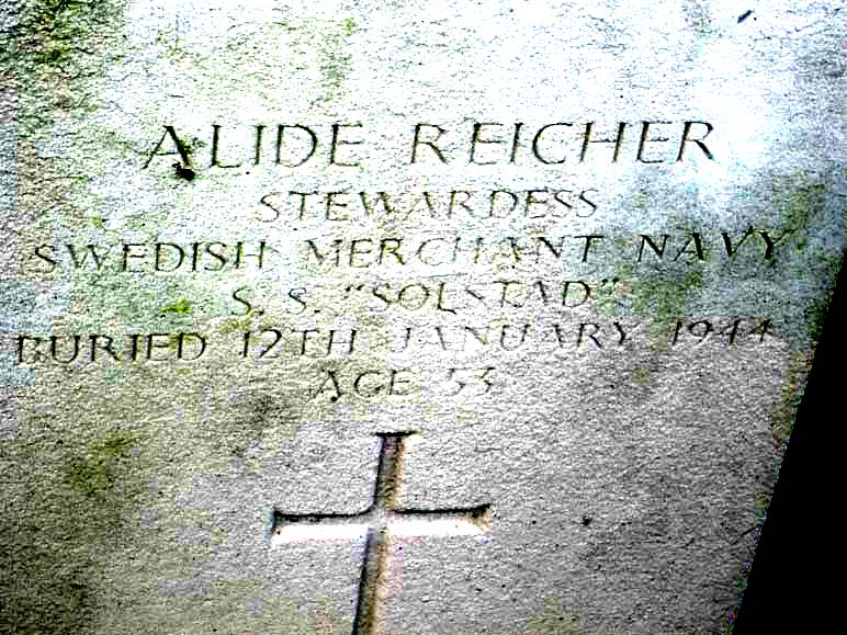
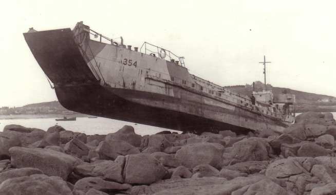