The Stirling Castle

Eat my Hat

Sailors kept their chewing tobacco in their hats, the linings of which became soaked in sweat and tobacco juice. If they ran out of tobacco they would take out the linings of their hats and chew them. [http://www.plymouth.gov.uk/navalsayingsdh accessed: 11.07.2016]

So this famous phrase has a nautical origin! Sailors and their hats are today’s theme:

One of the perks of being an archaeological conservator is that you get close to artefacts. Really close! Even closer! So close in fact, that you can hold, smell and properly look at artefacts: back, front, sides, and all around. And we conservators like to look closely. We like to see what an artefact is made from, how it is made, what condition it is in, and what that can tell us about the people that made or used it.

I recently had the privilege to work on the collection from the Stirling Castle protected wreck owned by the Isle of Thanet Archaeological Society on a project funded by Historic England’s commissions fund and headed by the Maritime Archaeology Trust. The main aim of this project was to catalogue and consolidate the archive, to enhance access to this fantastic wreck assemblage dating to the early 18th century.

Some of my favourite artefacts were beautiful knife handles, an ivory comb and copper alloy cauldrons. But two items stood out: leather hats. Items of clothing rarely survive in the archaeological context. But due to special preservation conditions for organic materials, such as leather, wool or linen, wreck sites play an important role in redressing the imbalance by allowing us an insight into clothing and dress, which are under-represented in collections when compared to non-organic materials, such as ceramics, for example.

Side view of crown and brim of brown leather hat, against a wide background.
Leather hat, Stirling Castle wreck assemblage, on loan from the Isle of Thanet Archaeological Society to the Shipwreck Museum, Hastings. Image © Historic England

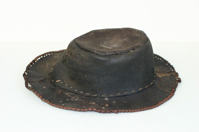
The hats stood out from the rest of the Stirling Castle collection for a number of reasons:

  • Beaver felt and wool seem to be the prevailing materials for hats of this period both in surviving examples and in art;
  • The style and method of construction also appear unusual for the period;
  • They are very well preserved: they are better-preserved than other leather artefacts from the same collection, such as the shoes or book covers;
  • There are no parallel finds known to us at the time of writing

Because these hats are so unusual, we are trying to learn as much about them as possible. They are a strong contrast to the leather shoes which are regularly found in shipwreck contexts and are well-understood, e.g. Mary Rose (1545); London (1665), HMS Invincible (1758).

Component parts of black leather shoes, such as uppers, heels and small parts, laid out together against a white background, with a ruler at bottom left for scale.
Leather shoes from the Stirling Castle wreck assemblage. Image © Historic England.

And this is where you come in: We have embarked on a project to study and investigate these two hats from various angles. We have chosen a multidisciplinary approach combining scientific investigations with art historical research as well as citizen science.

We’ve identified some surviving hats and contemporary images of hats, but we need your help to find more. We are putting the word out there asking members of the public as well as museums and collections to look at paintings and drawings of hats, or even hats themselves, dating to around the end of the 17th to early 18th centuries. Our aim is to collate a database of other hats and depictions of hats, to be able to compare our two hats from the Stirling Castle with other examples.

Here is the other hat from the assemblage:


View of brown leather hat against a white background, showing that the crown of the hat is laced together with a decorative thong.
Leather hat from the Stirling Castle wreck assemblage, Ramsgate Maritime Museum, showing thong lacing at the back. Image © Historic England

To examine the hats more closely, have a look at the 3D animations of the Hastings hat and the Ramsgate hat: click and drag to rotate in any direction, and see inside the hats, use mousewheel to zoom. (Best viewed in Firefox, Chrome, Opera, Safari 10.9 and above, IE 11)

As you can see, the hats are constructed in several pieces, with one piece for the top of the crown, the main body of the crown overlaps at the front and is laced at the back with a thong, and finally a wide brim.

We are mainly focussing on maritime scenes in paintings and drawings, due to the obvious maritime connection of the hats to the wreck of the Stirling Castle, but are interested in other depictions or real-life examples of similar looking head gear from other contexts too, perhaps hats worn by working-class people such as labourers and agricultural workers. These can be of any date to help with the comparison, but late 17th to early 18th century works would be especially helpful.

Please tell us as much as you can about the images or surviving examples of hats: where they’re from, their date and context, and a brief description of the style of hat, and its construction, and send us a link or photograph if possible.

As an example of what we’re looking for, have a look at this engaging 18th century image and the caption we have written for it.

Painting in neutral shades depicting two men, one wearing a hat and white shirt, clutching a wine bottle, the other behind his outstretched arm, looking at him. This man has a patched sleeve and holds a wine glass.
unknown artist, European School, 18th century; The Wine Seller; Southend Museums Service; http://www.artuk.org/artworks/the-wine-seller-2514. (Creative Commons license). The wine seller wears a brown hat with a low, wide, rounded crown, and a shaped wide brim. The texture suggests it may be a felt hat, as was usual for hats of this period.

The citizen science part of the project opens today, 1st August 2016, and will run until 31st August 2016. It will be shared on the @HE_Maritime Twitter account with the hashtag #LeatherHats. Please feel free to share widely, using the same #LeatherHats hashtag. If you have any clues, ideas or images of hats you would like to share with us, please contact us by commenting on this blog, on Twitter @HE_Maritime, or by e-mail at StirlingCastleHats@HistoricEngland.org.uk

Thank you!

Angela Middleton, Archaeological Conservator, Historic England, and Serena Cant, Marine Information Officer, Historic England.


U-8

The oldest First World War German U-boat and the earliest German submarine to be sunk in English territorial waters – the U-8 – has been given protection by the Secretary of State for Culture as a Protected Historic Wreck site, on the advice of Historic England.

Pioneering underwater survey techniques were used in 2015 to survey the site and assist the case for its protection.

Exploring New Technologies for Underwater Research

Historic England recently commissioned an innovative survey of a First World War submarine wreck in order provide data to support its protection and to test the application of new equipment for archaeological research.

Autonomous Underwater Vehicles (AUVs) have been used offshore for some time and the development of smaller systems has opened up a range of inshore opportunities for archaeological investigation. With recent advances in technology, these small AUV systems boast a suite of remote sensors that can include impressive underwater survey tools: side-scan sonar, multibeam echosounder, sub-bottom profiler, magnetometer and an underwater camera.

In order to test such a system for use in underwater archaeology, we commissioned Wessex Archaeology to carry out an AUV survey of the German U-Boat U-8 located some 10 nautical miles off Dover. Our First World War wreck diary provides more details of the loss of the U-8.

For the investigation, we deployed an Ocean Server Iver3 AUV which carried Edgetech 2205 sonar transducers and towed a Marine Magnetics Explorer magnetometer (Fig. 1). The AUV was about 2m in length and weighed approximately 40kg; light enough to be deployed by two people. The stated endurance of 8 hours was enough to ensure sufficient coverage of the U-8 target area. However, it was not known how the system would cope with a moderate sea state and tidal streams of up to 2.6 knots, so it was therefore decided to deploy the system to coincide with slack water during neap tides to give the best operational window possible.

Man dressed in black to the right of the image looks over the railing of a boat at an underwater vehicle on the surface of the water to his left.
Fig. 1. The AUV used to survey the U-8. © Wessex Archaeology

Before the AUV could be used to acquire data over the U-8, its buoyancy needed to be adjusted for the salinity and density of the seawater and the underwater survey lines were planned on a laptop with software calculating where the AUV needed to dive down and where it was to come back up. Survey positioning was provided by a GPS receiver within the AUV when at the surface and below the surface positioning was provided by a RDI Doppler velocity log, depth sensor and corrected compass. The AUV can only be communicated with via Wi-Fi when it is at the surface.

Deployment of the AUV at the wreck site was relatively straightforward, even in the slight to moderate sea state encountered, and it was programmed to fly around 10m off the seabed. Unlike a conventional towed system though, the geophysicist was unable to see live images of data as the sensor passed over the seabed: there is no way of knowing that the data is of sufficient quality or that the survey lines have been positioned correctly to ensonify (image) the target site, until the AUV is recovered to the vessel. This can make for a nervous time whilst the geophysicist is waiting to see the data!

The sea state did have an effect on the performance of the AUV whilst in the water in two ways. Firstly, the waves tended to swamp the ‘conning tower’ containing the GPS tracking system, which meant that the AUV sometimes had difficulty acquiring a GPS signal, causing it to refuse to start surveying. Secondly, when slack water was lost, the AUV struggled to get into its start of line position as it laboured against the tide, unable to dive. However, its endurance seemed good despite this, with the AUV deployed for about 6 hours with no requirement for a battery change.

Following recovery of the AUV and data download we could see that the side-scan sonar imagery showed a clearly defined submarine with detail of the conning tower visible. Sharp detail was observed in the acoustic shadow that shows the presence of three distinct upstanding narrow features, two on the conning tower (possibly periscopes) and one just behind (interpreted as the radio mast) (Fig. 2).The magnetometer data was also of good quality with a large magnetic anomaly observed over the location of the wreck, as would be expected.

Side-scan sonar image showing vessel on its side, with its central structure clearly visible, picked out in white against an undulating textured yellowish brown background representing the seabed.
Fig. 2.  Image of the U-8 in side-scan sonar data. Crown copyright, image by Wessex Archaeology

Some challenges were identified with the bathymetry data, particularly where some of the smaller features observed in the side-scan sonar imagery were not visible owing to the relatively low resolution of the bathymetry (Fig. 3). In addition, the on-board camera did not pick up any footage of the U-8 despite the visibility being around 8m.

Multi-coloured textured image of seabed set against a plain black background. The seabed is primarily greens and blues, with a raised section in reddish hues representing the wreck above the seabed.
Fig. 3. Image of the U-8 in multibeam bathymetry data. Crown copyright, image by Wessex Archaeology

During this, our first, archaeological trial of an AUV, the system performed reasonably well, giving sharp imagery that has aided our interpretation of the U-8’s condition. We’ve learnt some important lessons for future operations, particularly in understanding the effects of tidal currents on the AUV during data collection. Use of the AUV proved a cost-effective method of survey in a busy shipping channel with the same methodology being applicable to other sites that are similarly difficult to reach, such as those in proximity to shore, those in deep water, or otherwise restricted in some way. The system is also particularly well suited to more benign waters such as ports, or natural and manmade harbours, and if the circumstances allow the system to be launched from shore, then the cost savings could be considerable when compared to established survey methods.

Toby Gane and Dr Stephanie Arnott, with Mark Dunkley

Toby Gane is a Senior Project Manager and Stephanie Arnott is a Senior Marine Geophysicist at Wessex Archaeology.

Mark Dunkley is Historic England’s marine designation adviser.

Diary of the War No.21

Today’s post commemorates the Danish cargo vessel Asger Ryg, which disappeared in the English Channel on 6 April 1916.

She was built as the German Mimi Horn in 1902, but was sold the same year into Danish service as Asger Ryg for A/S D/S Skjalm Hvide (The Skjalm Hvide Steamship Company). The company’s name commemorated an 11th century chieftain of Sjaelland in Denmark, so what more appropriate name for one of their ships than that of one of his sons, Asger Ryg?

The Asger Ryg was bound from the Tyne with coal for Algiers when she disappeared with all hands. An official Danish source attributed the sinking to “being torpedoed or collision with a sea-mine”. That source was the Statistical Overview of Shipping Losses for the year 1916 of Danish Ships lost in Danish and Foreign Waters and Foreign Ships lost in Danish Waters (1) modelled on the British Board of Trade Casualty Returns, which had similar contents, but the Danish version also places a strong emphasis on narrative, making it more detailed in many respects.

Asger Ryg was sighted ‘to the south of the Isle of Wight in a badly damaged condition. It is supposed that she has been torpedoed.’ (2) The wreck was claimed by UB-29 as having been torpedoed just west of Beachy Head, (3) suggesting that her victim had drifted some distance before finally sinking.

The Asger Ryg‘s entry in the Statistical Overview reveals that she was valued at 700,000 kroner, and, together with many of the other vessels registered as lost that year, was also insured for war risks, at 924,000 kroner. Neutral Denmark was in a difficult position, with Germany on her sole land border and trade with Britain across the North Sea an important source of income. On the other hand, mines were no respecters of nationality or neutrality.

Denmark therefore continued to trade with both nations, but, as the German blockade of Britain intensified, ships carrying British cargoes became collateral damage in the efforts to strike at British trade. In English waters alone, we know of some 30 Danish ships lost during the First World War after being torpedoed, with further Danish vessels being lost to mines. (4) In a worldwide context losses were even greater. A few days after the loss of Asger Ryg it was reported that up to this point in the war the tally of Danish losses was 42 worldwide. (5) One of those was the Skodsborg, torpedoed a few weeks earlier, also by UB-29, off Suffolk.

Black and white profile view of steamship with single prominent funnel.
This may be Asger Ryg‘s wartime livery. Note that her name is painted in large white letters amidships. This was certainly the practice adopted by Norwegian vessels 1916-17, signalling their national identity at a distance in an effort to avoid being targeted.  Copyright unknown: wrecksite.eu

War risk insurance, therefore, was essential, a contingency that was prepared for from the outset, at least in Britain, where the State War Risk Insurance office opened the day after the declaration of war: the result of a collaboration between the Government and Lloyd’s of London. This innovative approach for British ships in 1914 would see further changes in the insurance industry to ease the pressure as their clerks left for the forces. In May 1916, therefore, a new Policy Signing Office opened, staffed almost entirely by women, to speed up the processing of policies. (6)

As the mounting toll of Danish ships demonstrates, by the early summer of 1916 it was acknowledged that neutral vessels were running significant risks: ‘For some time past a rate of 1 per cent has been accepted on the London market to cover the war risk in goods on neutral steamers across the North Atlantic.’ (7)  Thus, although neutral, each Danish ship was fighting its own war to stay afloat.

This is not the first post on the subject of neutral shipping lost in English waters – the War Diary opened with the Skúli Fógeti – and will not be the last.

(1) Statistisk Oversigt over de I Aaret 1916 for Danske Skibe i Dansk og Fremmede Farvande samt for Fremmede Skibe i Dansk Farvande: Bianco Lunos Bogtrykkeri, Copenhagen, 1917

(2) New York Times, 10 April 1916

(3) uboat.net

(4) National Record of the Historic Environment, valid as at 5 April 2016.

(5) New York Times, 13 April 1916

(6) The Times, 7 May 1916, p9

(7) The Times, 5 June 1916, p15


Diary of the War No.20

L15

In the second part of our Zeppelin double bill, we turn now to the tale of L15 as a counterpart to the story of L19 and Franz Fischer in Part 1. Like L19, L15 was a veteran of the raid on the West Midlands of 31 January/1 February 1916, and had, unlike the former, returned safely from that operation. She would survive to see two more months of activity.

Her final operation, together with six other Zeppelins, was planned for the week beginning March 31, when there would be minimal moonlight. (1) Admiral Scheer’s signal, briefing the German High Sea Fleet on the impending raid on southern England that night, was intercepted by British intelligence and a minesweeper tracked the Zeppelin, sending a report to Lowestoft. The British naval machine swung into action, with destroyers taking station off the east coast, just as the raid began over Essex and Suffolk.

L15 crossed the coast over Suffolk and, according to the later British official history, ‘followed the track of the Great Eastern Railway towards London, dropping a few bombs on Ipswich and Colchester as she passed’. As she lumbered south-westwards over the Thames ‘she was heavily engaged by the numerous anti-aircraft batteries’ on both the north and south banks at Purfleet, Erith, and Plumstead. L15 was forced to jettison her bombs over Rainham and turn back towards Germany, but not before the Purfleet battery had scored a hit.

The disabled Zeppelin was then intercepted by Alfred de Bathe Brandon of the Royal Flying Corps at Hainault, in a BE 2C biplane: he climbed above his target, attempting to bring her down by means of Ranken darts, a specific anti-Zeppelin weapon designed to pierce the skin of the hull. The airship then circled over Foulness, Essex, and dropped away, crashing into the sea near the Kentish Knock.

Colour image of Ranken dart next to its casing plate.
Ranken anti-Zeppelin dart, © IWM (MUN 3278)

It has been a matter of speculation ever since whether the Purfleet gun battery or Brandon’s action was ultimately responsible for the Zeppelin’s demise, or whether it was the combination of the two that made her the first Zeppelin to come down within English territorial waters. Official sources say nothing about a small explosion on board, but contemporary newspapers suggest that the crew had drawn lots as to who would be the last to stay behind after the rescue and blow up the airship, which would have meant almost certain death for the unlucky crew member. (2)

Oil painting of the hulked Zeppelin against a red and orange sky reflected in the sea with the black hulks of vessels in attendance.
St George and the Dragon, Donald Maxwell, 1917, depicting the downed L15 in the Thames. © IWM (IWM ART 888)


In the event, no self-immolation occurred, although, as the patrol trawler Olivine approached, a small explosion in the motor room was noted just before the Zeppelin crew surrendered. (2)

In contrast to the story of L19, the crew were not left to their fate by the trawler. All but one of the crew were rescued by the Olivine, and taken prisoner, although one had drowned before he could be picked up. But then the Olivine was not out alone in the remote expanses of the North Sea, but in a busy shipping lane bristling with warships and civilian vessels alike. The Zeppelin came down ‘in a flotilla of net drifters’ which the Olivine was guarding (1) and other patrol vessels were nearby: ‘That stretch of water . . . swarms with patrolling craft.’ (2)

‘She came down like a sick bird, flopping at both ends as though they were wings’, said one witness. (2) An hour and a half later, destroyers from the Nore tried to take her in tow but the operation was fraught with  difficulty, since ‘her stern was under water, the envelope was partly broken, and her back was broken.’ (1) After proceeding a very short distance, she collapsed and sank within hours of coming down,  but was eventually salvaged off Westgate, Kent.

The crew were taken to Chatham and the New York Times conducted an interview with the prisoners at the barracks, interrogating them on the impact of the raids and the loss of life among civilians, particularly women and children, so that on the whole the authorities’ decision to allow access to the prisoners resulted in a pro-British piece in the US press.

It turned out that Lieutenant Kuehne had been married only 8 days previously and he ‘was rather surprised to learn that his captors would allow him to write a letter to his bride. He confessed that he had no idea that the British could be so sympathetic.’ (3) He also sent his greetings to a London newspaper editor whom he had met before the war, demonstrating that there was still a residue of the mutual cordiality of pre-war Anglo-German relations. One final detail that emerged from the interview was that the night had been so cold and the Zeppelin flying so high that it was coated in frost and they ‘suffered severely’.

I’d like to end this blog on a personal note. Zeppelins would continue their raids on England in 1916 and beyond: for me these raids are only two generations away. My paternal grandmother went to see the site of another Zeppelin which came down at Great Burstead, Essex, in September 1916. She found the wreck guarded by policemen and soldiers but was profoundly shocked on arrival to see that the soldiers had already looted pieces of debris and were selling them to the public! This was hardly surprising since souvenirs from L15 are also known to survive, with several being in the collections of the Imperial War Museum, London (no images available).

(1) Naval Staff Monographs No.31, Vol. XV: Home Waters: Part VI: From October 1915 to May 1916, pp178-180. Admiralty, London

(2) New York Times, April 2, 1916

(3) New York Times, April 3, 1916

Diary of the War No.19

Franz Fischer

Interned German vessels have been a recurring theme or leitmotiv in this Diary of the War blog. This month’s double bill begins with another example, the Franz Fischer, detained as a prize at Sharpness in 1914, and the doubts over her manner of loss.

It is a story that exemplifies the dangers of the sea as the war drew near to its half-way mark, with terror from above and a message in a bottle.

As with most other detained prizes, Franz Fischer helped to fill the gaps in the ranks of sunken colliers, being one of 34 ships managed as colliers for the Admiralty by the Newcastle firm of Everett & Newbigin.(1) (Ironically she was the ex-British Rocklands, sold to Germany in 1913.) Despite reverting to Britain as a prize, she retained her recent German name, and it was as the Franz Fischer that she set off on her final voyage from Hartlepool on 31 January 1916, bound for Cowes with 1,020 tons of coal.

Around 9.30pm the following evening, having been informed that there were mines to be seen ahead, Franz Fischer prudently joined a group of laden vessels at anchor off the Kentish Knock Buoy.

What happened next was shrouded in some mystery. At 10.30pm Franz Fischer was rocked by an explosion amidships and sank within a couple of minutes at most. Only three men out of her 16-strong crew – a seaman from Newfoundland, the chief engineer, from Tyneside, and the steward,  a Londoner – survived to be picked up alive by the Belgian steamer SS Paul, by which time they were ‘close to collapse’, having heard the cries of other survivors gradually dying away overnight. (2)

Their story was told by Alfred Noyes in his serial for the Times, “Open Boats”, (3). (His radio drama of the same name was published in the New York Times as a powerful illustration of the sufferings endured by torpedoed crews.) The crew heard a noise approaching from the SE, which appeared to go away, then became ‘deafening’. As they investigated in the ‘black dark’ they were knocked off their feet by a ‘great mass of sea water which had been heaved up by the explosion.’ One survivor described an eerie sense that there was an aircraft ‘circling overhead in the darkness, dropping closer and closer to the vessel, like a great night-hawk’, the noise ‘several express trains all crossing a bridge together’ followed by a brief silence, then the explosion.

The chief engineer managed to swim to the lifebelt box, which rolled over when some of the crew tried to get onto it, so he decided to swim away. He managed to grab a lifebelt before passing out in the water: when he came to, he was aboard the Paul. (3)

The British press kept a beady eye on their German counterparts in a war of words that mirrored the physical war. The Wolff Bureau circulated a press release to German news outlets, claiming that the Franz Fischer had been sunk by a Zeppelin returning from the raid on England. The raid is well-documented, taking place on the night of 31 January to 1 February, so even at the Zeppelins’ lumbering speed they had already crossed the North Sea by the time the Franz Fischer was attacked.

All except one. L19 had engine trouble and crashed into the North Sea, where she was eventually found by a British fishing vessel, the King Stephen. The trawler crew rejected appeals from the Zeppelin crew for rescue, fearing that they would be overpowered and their vessel hijacked. The last heard from L19 was a despairing final report cast away in a bottle, dated at 1pm on 2 February, ‘wohl die letzte Stunde’, ‘at our last hour’. This message would wash up on the Swedish coast some 6 months later.

Front cover of French newspaper, with colour pen and ink illustration depicting an airship upended into the sea against a sunrise.
The front cover of Le Petit Journal, 27 February 1916: the headline reads “Punishing the Pirates”. Source: Wikimedia Commons

The trajectory of L19 can be reconstructed, from the Midlands (although the crew believed they had targeted Liverpool) to the east coast at Winterton, Norfolk, well north of the Kentish Knock, whence she drifted as far east as the Dutch coast. Anti-aircraft fire from the Dutch drove her away again and she came down in the North Sea.  The wreckage was eventually discovered some 120 miles off the Spurn, so her wanderings throughout appear to have been too far north for her to be Franz Fischer‘s nemesis.

The most likely cause of the explosion was not from the air but from below. UB17 was in the area, and her Kriegstagesbuch, ‘war diary’ or log book survives (4) noting an attack on a steamer at the Hoofden (the Kentish Knock). The first torpedo missed her target, but the second struck, sinking her within a minute and sending up a ‘column’ of smoke. This sounds close to British accounts, and by the time the official history of the war had been written in the 1920s, the wreck had been attributed to UB-17. The official history of the war at sea also came to the same conclusion: UB-17 was responsible, since ‘no enemy aeroplane or seaplane from Belgium is known to have gone out that evening; and probably the aircraft heard was one of our own.’ (5)

One hundred years ago the survivors of Franz Fischer felt themselves overshadowed by an aerial presence, which had nothing to do with the loss of their ship. L19 has overshadowed the story ever since. However, recent research and retranslation of the very difficult Suetterlin script of the original Kriegstagesbuch has uncovered that the first torpedo not only missed the target, but also misfired. ‘No track was to be seen: it was a dud.’ Could this misfiring have been part of the ominous noise heard by the survivors?

With especial thanks to Thomas Foerster,who transcribed the Kriegstagesbuch, and helped unlock its meaning, and to everyone who helped in various ways with this story – Angela Middleton and Marion Page of Historic England, and Matt Skelhorn of the MoD.

(1) Hansard, 2 June 1919

(2) Times, 4 February 1916, No.41,081, p.7

(3) Times, 23 December 1916, No.41,358, p.4

(4) UB-17 Kriegstagesbuch, 22 January-6 February 1916, Deutsches U-boot Museum, Cuxhaven

(5) Naval Staff Monographs No.31, Vol. XV: Home Waters: Part VI: From October 1915 to May 1916, pp62-5. Admiralty, London


Diary of the War No.18

The Algerian

For the first post of 2016 I am delighted to welcome our guest blogger, Amelia Astley, a PhD student at the University of Southampton, who has specialised in the study of shipwreck site formation processes through the use of multibeam bathymetry time-series. Here she describes one of the wrecks she has studied, the Algerian, lost a century ago on 12 January 1916.

Life of the Algerian

The Algerian, originally named Flintshire, was built in 1896 by the Sunderland Shipbuilding Company and made up part of the Shire Line [1]. She had a tonnage of 3815grt, length of 111m, beam of 13m and a service speed of 10 knots [2]. Following 21 years of service she was bought by the Royal Mail Steam Packet Co., where she remained for six years, before being purchased by the Ellerman Line Ltd. for their Levant service, under the name Algerian.

Black and white photograph of a ship with the name Algerian in letters beneath the bows,
A photo of the Algerian. [3]
Fate of the Algerian

At 8.20am on the 12th January 1916 the Algerian departed from Cowes Road, Isle of Wight, heading for Avonmouth [4]. After travelling just 26km along her 600km journey, at 10:15am, she hit a mine 4km southwest of the Needles.  It was later determined that this mine had been laid by the German submarine, UC-5, almost three months earlier [5]. The contact mine exploded on her starboard side, abreast of No. 2 hatch [6]. All of the crew bailed into three lifeboats. However, after realising the vessel wasn’t sinking, the captain and a few other members of the crew re-boarded [4]. For now the flooding was contained to just holds No. 1 and No. 2.

Three Admiralty armed drifters responded to distress signals, as well as the SS Warden, a Trinity House vessel, which assisted in the tow for Southampton, as did the tug Walvisch. By 2pm the vessel was approaching the boom defence near Cowes [4]. The tide was running strong and there were concerns that the Algerian was set on course to collide with the boom vessel Magda. As a result the Algerian was ordered to drop anchor.

Colour map of the Solent with purple line showing outbound voyage and yellow line depicting inbound voyage, with terminal points marked by a mine symbol and a wreck symbol representing the location where the vessel struck the mine and where she sank.
Route of the final voyage of the Algerian, showing the mine laid by UC-5, and the final wrecking position.

The No. 1 bulkhead finally gave way as the ship came to a standstill (it is not known whether or not this was a direct result of letting the anchor go). Attempts were made at securing tows to the beach, but these failed as the ship started to rapidly sink, bows first, causing the crew to again abandon ship. The vessel sank on her port side into a deep water channel to a depth of 22m just one mile off Egypt Point at a time of 2:30pm [6].  Fortunately all crew made it off the ship safely and the ship was in ballast at the time, so there was no cargo to retrieve [1].

Originally a diver was to be sent down to the wreck to ascertain the cause of the explosion (it was not yet confirmed to be a mine). However, the loss of the HMT Albion II to a mine near the Needles the following day is thought to have satisfied the Admiralty that a mine was the cause, since there is no record of a diver ever visiting the wreck [4]. The wreck, like many others, lay undisturbed until the end of the war.

A series of attempts were made to disperse the wreck throughout the 1920s and her structure was reduced in height by approximately  6.5m [7]. Although the ship had a beam of just 13m, the wreck structure in 1978 measured 30m wide[7], suggesting that the ship lies directly on her side, and is consistent with the vessel’s hull depth of 28m.

Present day

The wreck of the Algerian is situated approximately 1.25km northwest of Gurnard, Isle of Wight, at a depth of 20 to 22m below chart datum and is aligned 61/241° (with its bow towards the north-east). The wreck structure measures 107m long, 28m wide and stands proud of the seabed by 5.8m at its highest point.

Location map of the Algerian, seen as a black star, with the land on either side illustrated in black and white, and the surrounding seabed depth illustrated by different colours shading from red at the shallowest to blue at the deepest.
Location map of wreck of the Algerian and the location of the nearest Tidal Diamond and Wave Buoy, overlain on 2006 and 2011 MCA multibeam bathymetry (Contains public sector information, licensed under the Open Government Licence v2.0, from Maritime Coastguard Agency).

Five high-resolution multibeam bathymetry surveys spanning three years have been collected using the University of Southampton’s vessel Callista. These multibeam bathymetry time-series are used to study the evolution with time of the wreck structure and surrounding seabed. The site is remarkably sheltered and is situated on a bed made up of coarse gravels, which require strong currents to be transported. As a result the wreck site has undergone little change over the three year (2012 – 2015) observation period.

Nevertheless, divers have observed that the wreck frequently acts as a nucleus for the collection of traffic cones, patio chairs, drinks cans and other debris. [8]

Computer-generated image of the wreck site on the seabed, showing a jumbled mass of darker metal in grey against a grey background of sandwaves.
Point cloud image of the wreck with sunlight shading, seen from the northern side of the wreck, derived from the 2015 survey. © Amelia Astley, University of Southampton


References

[1]         Tennent A J. British Merchant Ships Sunk by U-boats in World War One. 2nd ed. Penzance: Periscope Publishing Ltd; 2006.

[2]         Merchant Navy Association. Shire Line 2015. http://www.red-duster.co.uk/shire7.htm (accessed May 1, 2015).

[3]         PhotoShip. Album: Old Ships A 2015. http://www.photoship.co.uk/JAlbum Ships/Old Ships A/index12.html (accessed March 20, 2015).

[4]         Maritime Archaeology Trust. Forgotten wrecks of the First World War: SS Algerian 2015. http://www.forgottenwrecks.org/index.php/forgottenwrecks/casestudywrecks/ss-algerian (accessed May 1, 2015).

[5]         Naval staff monographs (Historical). Volume XV. Home waters – part VI. From October 2015 to May 1916. London: Admiralty; 1926.

[6]         Larn R, Larn B. Shipwreck index of the British Isles: Hampshire, Isle of Wight, Sussex, Kent (Mainland), Kent (Downs), Goodwin Sands, Thames. London: Lloyd’s Register of Shipping; 1995.

[7]         United Kingdom Hydrographic Office (UKHO). Hydrographic Office wreck index: Algerian (013503820). n.d.

[8]         pers. comm., Wight Spirit Diving Charters, 2015


No. 96 HMT Resono

Diary of the War No. 17

In the second part of our Christmas double bill, we commemorate a loss on Boxing Day 1915 and finish off with a poem as an extra special feature.

We have looked at fishing vessels in the War Diary before – how, at the outbreak of war, neutral fishing vessels found themselves on an unexpected front line of minefields, how the sailing fishing fleets of Lowestoftwere targeted and how they fought back.

In commemorating the loss of HMT Resono 100 years ago, today’s post pays tribute to the efforts of the steam trawling fleets. They saw action principally as minesweepers and patrol vessels, many requisitioned from the beginning of the war. They were eminently suitable to backfill these roles: as smaller ships, they were at less risk of detonating mines, their crews knew the seas intimately, and they needed little modification.

Sweeping was monotonous, deadly, and dangerous, with a high casualty rate: it was inevitable that a number of sweepers and patrol vessels would be lost in the minefields littered around the coastline. On 26th December 1915, Resono, one of the famous Sleight fleet of trawlers operating out of Grimsby, was blown up 2 miles SE of the Sunk Light Vessel in the Thames Estuary.

The Sleight fleet saw distinguished service in both World Wars. Sir George Sleight’s obituary of 1921 states that over 50 of his ships were requisitioned: it also states that he developed from a cockle-gatherer to the owner of the largest steam trawler company in the world. (1) His fleet is readily identifiable among wartime casualty lists by its distinctive house naming scheme: Recepto, Remarko, and Remindo were other First World War losses from the fleet. Many Sleight vessels participated in both wars: Resolvo and Resparko, First World War veterans, were both lost in 1940. Yet others survived two wartime services, including the Revello, built in 1908 and therefore a contemporary of Resono, which was eventually wrecked in 1959.

Black and white photo of steam trawler, with steam coming out of its funnel.
Sleight trawler Revello, which sprang a leak and sank off Kilnsea in 1959, after seeing service in both World Wars. She had been sunk in 1941, but was salvaged a few months later. © Scarborough Maritime Heritage Centre. George Scales Maritime Photographs.

To conclude this month’s edition of the War Diary, here is Kipling’s poem Mine Sweepers, also a century old. It was first published as the introduction to an article on the work of the minesweeper-trawlers for the Daily Telegraph, 23rd November 1915: the original can be read here.

Dawn off the Foreland – the young flood making

Jumbled and short and steep –

Black in the hollows and bright where it’s breaking –

Awkward water to sweep.

“Mines reported in the fairway,

“Warn all traffic and detain.

“Sent up Unity, Claribel, Assyrian, Stormcock, and Golden Gain.”


Noon off the Foreland – the first ebb making

Lumpy and strong in the bight.

Boom after boom, and the golf-hut shaking

And the jackdaws wild with fright!

“Mines located in the fairway,

“Boats now working up the chain,

“Sweepers – Unity, Claribel, Assyrian, Stormcock, and Golden Gain.”


Dusk off the Foreland – the last light going

And the traffic crowding through,

And five damned trawlers with their syreens blowing

Heading the whole review!

“Sweep completed in the fairway.

“No more mines remain.

“Sent back Unity, Claribel, Assyrian, Stormcock, and Golden Gain.”

To borrow a phrase: the poem counted them all out and counted them all back!

(1) The Times, Monday 21 March, 1921, No.42,674, p16.

No. 95 Thomas W Lawson

In the first part of a special Christmas double bill, it is my pleasure to . introduce my guest blogger John Hicks, who, as a descendant of those involved in the rescue, has recently written a book on the wreck of the Thomas W Lawson.

Lawson.jacket
Cover of the book, depicting the largest sailing ship in the world  as a sad wreck among the Isles of Scilly.

He writes:

The Isles of Scilly, off the south-west tip of Great Britain, have been the scene of innumerable wrecks (over 900 have been recorded by name), of which probably the best known are those of Admiral Sir Cloudesley Shovell’s flagship HMS Association and three other vessels from his homecoming fleet in 1707, with the loss of the Admiral and an estimated 1,400 to 2,000 others, and of the Schiller, a 3,421 ton German transatlantic liner, in 1875, with the loss of most of her crew and passengers, to a total of 335.

The name of the Thomas W Lawson, while not so notorious among the general public, is well known locally, and among many others with an interest in wrecks. Towards sunset on Friday, 13 December 1907 she reached the mouth of  the English Channel after a stormy first transatlantic crossing and with another gale brewing. Thinking themselves well clear of any land, the crew realised, too late, that they were among the rocks and shoals of the islands and hurriedly anchored. She was attended by the St Agnes and St Mary’s lifeboats, but for different reasons each had to return to its station.  In the night there was a violent storm, and by the small hours of the following  morning the Lawson was a wreck.  At daylight a six-oared island gig was launched into a still high sea to search for survivors, and by the end of the day, after three perilous trips among the rocks, had rescued the only three, one of whom died within hours of his injuries.

That brief narrative omits many dramatic, intriguing or disputed details, but in addition to the fascination of the immediate story there are at least three other features of great interest in the vessel and personnel involved.

As to the vessel, she was a seven-masted schooner of 5,218 registered tons, the largest fore-and-aft rigged sailing vessel of all time, at the time of her loss the largest sailing vessel of any rig afloat, and still the largest vessel propelled purely by sail throughout her life which has yet existed.

Black and white photograph of five-masted sailing ship aground in shallow water off a rocky coastline in the foreground.
Besides the seven-masted Thomas W Lawson lost off the Isles of Scilly in 1907, there was also the wreck of the five-masted ship Preussen off Kent in 1912, photographed here by a local resident. BB052702 Reproduced by permission of Historic England.

As to the personnel, there was first the man after whom she was named: one of the moving spirits behind her conception and creation and a major participant in her financing and ownership.  Thomas W Lawson was a buccaneering and intensely superstitious Boston stockbroker who started work as a fatherless, penniless boy of 12, made and lost several fortunes, was reputedly worth at his zenith some $30 to $50 million (the equivalent of something like $750 million to $1.25 billion now) but died in poverty.

And finally – there was the tiny, isolated, close-knit island community into which the schooner irrupted.  Of the 17 men from St Agnes who went out in their lifeboat to the Lawson on the 13th or in their gig to search the rocks on the  14th or who (in four cases) were involved in both ventures, all but one were related and 13 bore the same surname.  One of them was aboard her as pilot when she went down, and was drowned.

There have been many accounts of the wreck of the Thomas W Lawson, but it is now the subject of a full-length investigation into all these features and their interrelation.  It is entitled An Absolute Wreck and its author is a great-nephew of the dead pilot and related to all but one of the St Agnes men involved.

Serena adds: the Isles of Scilly gig was an adaptable craft, often a salvage and rescue vessel at need, and involved in other incidents. Wrecks sometimes caused other wrecks of those that went to their aid: we know of two gigs that were lost respectively in a rescue attempt in 1816 and in salvage work in 1839, underlining the courage of those who crewed them.

Publication details of An Absolute Wreck: the loss of the Thomas W Lawson are as follows:

Title:  An Absolute Wreck – the loss of the Thomas W Lawson

Author: John Hicks

Publisher: Scotforth Books, on behalf of the author

ISBN: 978-1-9098 17-25-8

Date: 2015

Price: £15.00, including postage within the UK (in USA $25.00 plus postage from UK)

Obtainable from the author at john.hicks@montagusquare.net

No. 94 HMHS Anglia

Diary of the War No.16

Today’s First World War Diary entry commemorates the loss of HMHS Anglia on 17 November 1915. Built in 1900 for the London and North-Western Railway, she became one of many civilian vessels requisitioned for war service. A couple of months ago, in the story of the Africa, we saw how railway companies at home built and exported railway carriages to support the evacuation of wounded servicemen from the front overseas. The ferries owned by railway companies also played their part: Anglia‘s peacetime role as a passenger vessel fitted her well for her wartime function as a hospital ship.

It was on one such journey from Boulogne to Dover, carrying nearly 400 wounded soldiers and medical staff, that Anglia struck a mine laid by UC-5 in the Straits of Dover. UC-5 had been active in mining the key route from London to France, laying fields off the Sunk in the Thames Estuary, off Dover, and off Boulogne itself. (1) Following the explosion the boats were got out and the first party of 50 quickly escaped.

Black and white photograph of rowing boats in foreground and middle ground, steering away from sinking hospital ship in the background. To the right background a black vessel stands by to assist.
Anglia, in her hospital ship livery, after striking the mine; to the right another ship (in black) can be seen standing by, identified as HM TB No.4, though published in the Illustrated London News in January 1916 with a caption identifying her as the Lusitania. The high viewpoint shows that the photograph has been taken from another vessel, rather than from a boat. © IWM Q22867.

The ship then began to list heavily and sank so rapidly that some of the crew and passengers, soldiers and medical staff alike, unfortunately went down with her. The exact numbers are not quite clear but it is believed around 129 persons lost their lives, including some of the wounded.

Black and white photograph of vessel sinking, throwing up spray, and resulting in visible sea turbulence.
This photograph of the Anglia‘s sinking shows the impact of her final plunge. © IWM 822866.

One of the vessels which steamed to her assistance was the Lusitania, bound from London to Lisbon and Cadiz, a route reflected in her name, by which the Romans had known their province roughly corresponding to modern Portugal. By coincidence, she was also lost to enemy action in the same year as the more famous vessel of that name, as she subsequently struck a mine in the same field as the Anglia, and sank half a mile south.

Three-dimensional colour image of wreck on the seabed, picked out in contrast colours modelling the wreck, with dark blue the seabed, light blue the lowest point and red showing the highest points of the wreck.
The Anglia as she now lies, from a multibeam survey in 2014. Wessex Archaeology © Crown copyright.

Anglia was not the first hospital ship loss of the war, nor would she be the last. (In a previous War Diary entry we have looked at the Rohilla, lost on the rocks near Whitby in October 1914.) The Red Cross livery signalled Anglia‘s humanitarian function to friend and foe alike, but was no talisman against minefields, which respected neither nationality nor function. Those evacuated from the front were saved from one hell, only for some to lose their lives in another.

Update 02 December 2015: ‘Twice Shipwrecked in an Hour’. For an interesting article looking at some of the survivors of Anglia and Lusitania, click here.

(1) Naval Staff Monographs (Historical), Vol. XV Home Waters – Part VI: from October 1915 to May 1916, Admiralty, London, 1926

No. 93 Ionic Star

Degrees of separation 

Today I have the pleasure of introducing my guest bloggers Mark Adams, Archaeological Services Manager, Museum of Liverpool, and local historian Martyn Griffiths, who describe the wreck of the Ionic Star on the anniversary of her loss in 1939. The Ionic Star has a connection with one of the most famous wrecks of the Second World War in fewer than ‘six degrees of separation’, as Mark and Martyn demonstrate in words and pictures below. For more links, please see the bottom of the article, including drone footage of the site as she now lies. Many thanks to them both.

The Sefton Coastline in Merseyside is a belt of wide sandy beaches and dunes which run from Formby in the south to Southport in the north. Possibly better known to archaeologists for the prehistoric footprints recorded by Gordon Roberts, the area also has a rich maritime history, largely a result of its location on the approaches to Liverpool. This includes the remains of Britain’s first Lifeboat Station and several shipwrecks, some of which are accessible by foot in the company of an experienced guide.

One of these wrecks is the Ionic Star, which was researched by a local historian, Martyn Griffiths. Built in 1917 by Russell & Co. of Glasgow, she was a refrigerated cargo liner with dimensions of 389.8 x 53.2 x 32.4 feet, and had a triple-expansion steam engine by D. Rowan & Co., Glasgow. Launched as the Rubiera, she belonged to the Blue Star line and was renamed the Ionic Star in 1929.

Black and white photograph of steamship in side view, depicting a star logo on the funnel amidships.
Ionic Star, showing the Blue Star logo on her funnel.

She was wrecked on October 16th 1939, after having lost her way whilst steaming up the Mersey Channel. She was carrying a cargo of meat, fruit, and cotton and was inward bound from Rio de Janeiro and Santos in Brazil to Liverpool, but sank on the edge of Mad Wharf, about one mile west of Formby Point. Her cargo was saved and no lives were lost, though she later became a total loss.

Although a salvage firm tendered for the job of breaking her up for scrap and the offer was accepted by the Mersey Docks and Harbour Board, the difficult access with the rising and falling tides meant that they were only able to break up about 50 tons and then gave up the job.

During the war she was used as target practice by aircraft flying from the nearby RAF Woodvale and elsewhere, but a considerable amount still remains firmly embedded in the sand and she remains a significant local landmark.

View of shipwreck on sands at sunset, showing skeleton of vessel.
View of Ionic Star as she lies today on Mad Wharf, showing a significant break in the hull structure. © Martyn Griffiths

The Blue Star Line had several other steamers in their fleet at the time, one of which was the Doric Star. It was this steamer that only two months later on the 2nd December 1939 was to be sunk by the German Battleship Admiral Graf Spee off the coast of South Africa – rather a bad few months for the Blue Star line. Only 15 days were to go by until the Graf Spee herself was scuttled outside the harbour at Montevideo in the Battle of the River Plate.

Black and white photograph of German warship on fire and sinking, with smoke billowing out of the vessel to the right.
Graf Spee on fire following the Battle of the River Plate, December 1939.

The site was recently used for a test-flight of a UAV by Prof David Burton of the General Engineering Research Institute, Liverpool John Moores University, who supplied the dramatic video in the Youtube link.  The long-term aim of the group is to use a range of telemetry, including LiDAR, mounted on UAVs to provide a means of recording otherwise inaccessible sites such as the Ionic Star.  The flight was also run as part of a guided walk to the site organised by the Sefton Coast Landscape Partnership and Archaeological Services, Museum of Liverpool.

Links: 

http://www.bluestarline.org/ionic1.html

http://www.martyngriff.co.uk/page12.htm

http://formby-footprints.co.uk/

http://www.formbycivicsociety.org.uk/2003%2003%20originsbritainsfirstlifeboatstation.html

http://digiart-project.eu/consortium/ljmu/ljmu-geri/

http://www.liverpoolmuseums.org.uk/mol/archaeology/

https://www.youtube.com/watch?v=cph79ESYaWE

https://www.youtube.com/watch?v=OKEH-GsbvPk