In early 1944 Britain was watching and waiting. ‘Lorries and tanks kept rumbling towards the south coast, so we knew something was going to happen,’ in the words of Corporal Cant, based at RAF Ford, Sussex, describing the later spring of 1944. ‘Nobody said anything about it. But more and more of them were building up. We saw, and we knew, but we didn’t know when, and we didn’t talk about it.’
There is something of that sense of anticipation in the wreck highlighted for February 1944, LCI(S)511, Landing Craft Infantry (Small) 511, on the Channel coast facing a France that soon would be the focus of a liberation effort by just such craft. With the benefit of historical hindsight, we can say ‘soon’, but at the time it must have felt that ‘soon’ would never come: scenes such as the one below, in the countdown to D-Day, were months away.
All anyone could do was watch, wait, and play their part: and only those ‘in the know’ had an overview of what was happening behind the scenes. An initial joint plan, i.e. a combined Allied plan, was issued on 1 February for the invasion, with the naval outline plan following later that month. [2]
The Landing Craft Infantry (Small), LCI(S) for short, were built 1942-3 with bullet-proof armour plating over a wooden hull structure designed by the Fairmile Marine boatbuilding company, which specialised in motor boats (the company grew out of motor manufacture). The ‘Fairmile H’ design of the LCI(S) was produced in kit form and outsourced to other small boatbuilding firms for assembly, such as Leo Robinson at Oulton Broad, Suffolk, who built LCI(S)511 and LCI(S)533. [Explore Robinson’s yard in this historic image.] Others were built on Oulton Broad by Collins and Brook Marine, and production was dispersed countrywide, both because of the small scales of the yards and for security reasons. At 110 tons, 105 feet long x 22 feet wide, they were intended to carry a complement of around 100 men (descriptions vary from 96 to 102 troops). [3]
At the same time operational bases came into being in the run-up to D-Day. From 1942 the Southwick Ship Canal on the Sussex coast between Shoreham-by-Sea and Portslade became a Combined Operations Landing Craft Base, known as the ‘stone frigate’ HMS Lizard. HMS Lizard was further developed in 1943 and by January 1944 was ‘very busy’ with both large and small landing craft. Lizard‘s vessels and personnel are known to have participated in exercises over February 1944. [4]
The former river channel of the Adur was canalised to provide a harbour free from the natural silt deposit processes that were otherwise threatening to clog up the harbour mouth. It runs parallel to the seashore, with the river and harbour mouth further west, and sloping shingle beaches on the seaward side.
As a ship canal for both smaller and larger vessels, landing craft could be virtually hidden in plain sight, and as a USAAF air photo from April 1944 in Historic England’s collections shows, it would all appear quite innocuous, with existing buildings requisitioned to form the base, and a natural gathering place for craft.
The advantages of this location as a base were a natural seaward defence with an easily controlled harbour mouth, and on the shoreward side are sloping shingle beaches, ideal for rehearsing landings.
The day after the Allies issued their joint plan on 1 February 1944, LCI(S)511 was beached at Portslade, Sussex, to become a total loss. [5] What happened there? There seems to have been nothing particularly unusual about the weather that day, with local readings recording a force 4 (‘moderate breeze’) at south-westerly and temperatures mild, between 49-53 degrees Fahrenheit, which would be recorded as 9-11 degrees Celsius today. [6]
We know of at least 74 other vessels that were lost in force 4 conditions in English waters since records of weather conditions at the time of loss began in the mid-19th century. They tend to have two broad characteristics: either something else happened to them, such as springing a leak, running aground or involvement in a collision, i.e. factors which are not weather-dependent and can be overwhelming in themselves; or they were small vessels, fishing smacks, yachts, cutters, barges, and so on, which could be quite disproportionately affected by weather conditions, depending on wind direction and their activity or lading at the time.
Records appear to be quite brief, but it is possible to read between the lines a little. The key word is that LCI(S)511 was beached. There are only two reasons for beaching vessels, i.e. to deliberately put them ashore: the first, and more benign, reason, is that they can be effectively ‘parked’, as sailing colliers once did to deliver their coal on the Sussex coast, or fishing boats can still be seen today drawn up on the foreshore in many places – and, of course, beaching was what landing craft were designed to do!
As we have seen, much of the Sussex coast, as at Portslade, comprises a gently sloping shingle shoreline, ideal for beaching vessels, and this history of safe landing grounds was what fitted Portslade and Shoreham on either side of the Adur to be a landing craft base.
However, beaching on the foreshore can leave the craft so drawn up very vulnerable if a storm subsequently ensues. In other words, they can be safely beached, then lost after beaching, but this seems unlikely in the weather conditions reported for 2 February 1944. With the beach ideal for the landing craft’s function, the design of the vessel suited for that purpose, and the base so close by, and operational and repair support therefore easily accessible, it seems surprising that LCI(S)511 became a total loss, in the brief and bald facts available to us.
So possibly something happened to LCI(S)511 thatcaused her to be beached, rather than being beached in the natural course of exercises, say. We turn now to the less benign reason for beaching vessels, which tends to happen on the nearest shore in extremis, for example having sprung a leak, taken on water, following a collision, or to avoid running onto a significant hazard nearby. In other words, something has happened to force the ship to run ashore to avoid sinking at sea.
It therefore seems plausible that something happened to LCI(S)511 at sea, possibly taking on water for some reason, or perhaps a collision, after which it proved impossible to get her into the shelter of the ship canal basin. Such an event would be natural on exercises: naval exercises ‘gone wrong’ in some way have historically caused several wrecks that are well-documented in the record, and a prior contributory factor which forced the vessel ashore seems the most plausible reason for the ensuing total loss that was reported.
The date of loss does not tally with the major exercises that were undertaken in the run-up to D-Day, but as we know that HMS Lizard was involved in exercises in February 1944, it seems reasonable to surmise that there were smaller-scale and more localised exercises that fed into major rehearsals as preparations for the invasion gathered pace.
Thus LCI(S)511 has the potential to combine both broad characteristics of vessels lost in force 4 conditions: a hint of a prior background cause, not influenced by the weather, that forced her to be beached, and the relatively small size of the vessel more vulnerable to mild weather conditions once already damaged.
Epilogue: LCI(S)508 was, until recently, seen as Valeur among the houseboat community of Shoreham-by-Sea on the Adur, not far from where LCI(S)511 met her end. For more on her story, explore footnote [7].
Footnotes
[1] Cant, R, 2012 unpublished oral history reminiscence, recorded and documented by Serena Cant
[2] Naval Historical Branch (nd) Operation Neptune: The Normandy Invasion: D Day 6 June 1944 (Ministry of Defence: published online)
[3] Slee, G 2000- Combined Operations (published online); naval-history.net (nd) Royal Navy Vessels Lost at Sea, 1939-45 – by type: Amphibious Warfare Vessels (published online), based on HMSO British Vessels Lost at Sea 1914-18 and 1939-45 (London: HMSO) known as BVLS; Navypedia (nd) LCI(S) type small infantry landing craft (LCI(S)501) (1943) (published online); Wikipedia (nd) Fairmile H landing craft (published online)
[4] Royal Navy Research Archive (nd) HMS Lizard: Combined Operations Landing Craft Base (published online)
[5] BVLS, Section III, p56
[6] Met Office 1944 Daily Weather Report February 1944, 2 February 1944 (online)
[7] Spitfires of the Sea (nd) Shoreham Survivors (published online); O’Sullivan, T 2021 ‘Tales from the Riverbank’, Beach News: the magazine of Shoreham Beach Residents’ Association, Summer 2021 issue (online)
The SS Solstad – a Swedish ship torpedoed in Convoy WP 457
It’s hardly attention-grabbing to summarise the facts of a ship’s loss in the headline title. But the more you look at it, the more there is in those bald facts that piques curiosity.
Wasn’t Sweden neutral in the Second World War? Why was a ship from a neutral nation torpedoed? (Neutrals were never immune to loss from war causes: often mines, which struck indiscriminately, but our records show that they were often torpedo targets, too.) What, in fact, was a ship from a neutral country doing in a British-led convoy wholly within British waters voyaging from one British port to another?
The Loss Event
The convoy prefix WP indicates Wales to Portsmouth. On 2 January 1944 the MV Underwood left Liverpool, arriving 3 January at Milford Haven. That day the MV Polperrosailed from Ellesmere Port for Milford Haven, arriving 4 January; at the same time the SSSolstad left Swansea for Milford Haven. On 5 January the assembled convoy finally put to sea from Milford Haven for Portsmouth with their escorts, including the destroyer HMS Mackay and the Isles-class naval trawler (i.e. a purpose-built Admiralty trawler, rather than a requisitioned fishing vessel) HMT Wallasea. [1]
The convoy rounded Cape Cornwall and Land’s End and on 6 January 1944 seven E-boats (German Schnellboote, ‘fast boats’) of the German 5th Flotilla, divided into two flanks, under the command of Kapitänleutnant Karl Muller, were lying in wait to make a surprise attack from the landward. Just before 3am that morning, they opened fire. [2] At 5.25am the ‘resident naval officer at Penzance reported that a convoy had been attacked about five miles south of Treen coastguard hut’. [3] This suggests that the report had come from the coastguard at Treen. Twenty-five minutes later Penlee’s motor lifeboat W and S was on its way in a moderate south-westerly with a rough sea out into Mount’s Bay and on into the Channel. They found two rafts at the position stated, one with two men on it, and the other ten men and two women ‘survivors from the Swedish steamer Solstad, bound with coal from Swansea to London.’
The lifeboat picked them up, ‘made a further search, and found nothing’, radioing for medical assistance shoreside on arrival at 9am. She then ‘put out again and made a further search . . . found only wreckage . . . ‘
There was no sign of the convoy. They must have long swept past, with HMS Mackay having kept the 2nd group of E-boats at bay, while the E-boats themselves were on their way back to base at Brest.
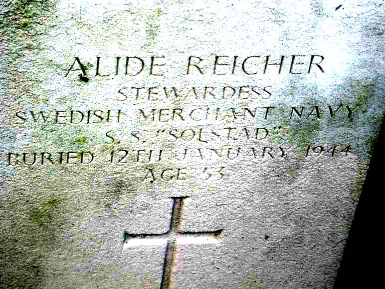
S 136and S 84 had sunk the Polperro, laden with coal, S 141 theUnderwood, carrying ‘Government stores’ on ‘Special Military Service’, i.e. war matériel, S 143 the Solstad, again with coal (1780 tons), and S 138 their escort Wallasea. There was loss of life from all four vessels: Polperro was lost with all hands; at least 13 deaths are recorded from the Underwood; and, although not everyone died aboard the Wallasea, the toll was particularly heavy, with 35 lives lost. Aboard Solstad one of those who died was a stewardess, Alide Reicher; two of the crew who died were, however, British. [4]
A mystery of location
All four are charted wrecks, but, of the group, only Underwood appears to have been positively identified from her propeller boss, approximately 4 miles NW of a cluster of sites derived from the reporting position of of 49˚ 57’N 005˚ 28’W on all three merchants’ Shipping Movement Cards. This includes the Underwood‘s own card, so she at least is not at the position reported therein. [5]HMT Wallasea does not have a Shipping Movement Card, but has also been assigned to the ‘cluster’ position. The Shipping Movement position is likely to have been reported by others in the convoy – the Trade Division Signal for the convoy reported 16 ships, so a fairly large and well spread out convoy – and is likely to be an approximation or aggregate of reported positions from the escorts and/or commodore (lead merchant). [6]
The three charted reports of Polperro, Wallasea and Solstad, clustered around those Shipping Movement Card co-ordinates are all ‘dead’ or ‘disproved’, i.e. do not represent wreck sites but are based on contemporary records, not archaeological remains. In any case, they are clustered around an approximate position, which is also somewhat at odds with the other position quoted, that attended by the RNLI, which at 5 miles south of Treen would be approximately 49˚ 57’N 005˚ 37’W.
Location map of the events of 6th January 1944, showing how the positions cited are at variance with one another: the lifeboat’s approximate voyage from Penlee to 5 miles south of Treen, where the Solstad was found, is shown. The yellow pin represents the known location of the Underwood, and the red pin the Shipping Movement Record cards’ approximate position for Polperro, Solstadand Underwood, and to which HMT Wallasea is also assigned. It has been proven inaccurate for Underwood, and in the light of the RNLI report, cannot be accurate for Solstad. The convoy direction was eastbound.
As we have observed in several of our previous blogs, it is not uncommon for wreck sites to be discovered some way from the location originally reported for all sorts of reasons, and in the case of a convoy the vessels would be dispersed over some distance. The position of Underwood is certainly 5 miles from Treen at approximately 49˚ 59’N 005˚ 31’W, but the bearing is SE of Treen, not south, and the ‘cluster’ location further away on a similar SE bearing.
When the RNLI first attended the wreck in the position given to them, 5 miles south of Treen, they found survivors from one ship, and when they returned they found wreckage, but it is not known how much of the wreckage was Solstad and which, if any, from the other ships – the RNLI report gives no further details. However, the discovery of Solstad‘s survivors suggests that the position reported to the RNLI was substantially correct, at least for that vessel. The lifeboat station at Penlee is on the western side of Mount’s Bay, and the lifeboat would have navigated southwards before rounding the coastline and bearing away to the south-west to intersect with the position given to them off Treen, with Underwood some 3 or 3.5 miles to the south-east as they moved out into the Channel, i.e. the identified position of Underwood now lies NE of the position to which they were bound.
The RNLI report does not mention any sighting of Underwood or any of the other vessels.
When they reached the scene to which they had been directed, they found only survivors from the Solstad; no other ships or survivors are reported (though there were survivors from Underwood and Wallasea, as well as Solstad, presumably picked up in convoy) so this does suggest that the other ships were, like Underwood, lost slightly outside both positions stated, i.e. the one given to the RNLI and the other reported on the Shipping Movement Cards. The loss of life, the fact that Solstad itself was not seen but rafts were, and the lack of any reported sighting of the other three by the lifeboat en route or at scene suggests that all four sank very quickly.
Can we reconstruct the convoy and the relative positions of the ships? The E-boats attacked from the landward side. Underwood at least might well have been on the port and landward flank of the convoy. As Solstad was at the position reported to the RNLI, then she was astern and to the south-west of the known position of Underwood. It is hard to see how HMS Mackayheld off further E-boat attack without being astern and to the west of the convoy, so close to Solstad, perhaps, and similarly Wallasea might have been the escort on the seaward flank.
Both the Merchant Shipping Movement Cards and the position off Treen reported to the RNLI either give or come out at the same latitude of approximately 49˚ 57’N, suggesting some accuracy at least to that half of the co-ordinates, potentially the starboard and seaward flank. It seems reasonable to suggest that the three unattributed wrecks in this convoy may therefore lie in an arc roughly bounded by the present position of Underwood to the north-east and the reported position of Solstad to the south-west.
The Solstad‘s loss report sheds no light on the matter, as it states ‘Sunk owing to war causes off South-West England about 6th January, 1944.’ [7]
Another mystery . . .
But to get back to the questions we asked at the start of the blog – what wasSolstad doing there in the first place? Why is there a neutral Swede in a British convoy? The answer lies in Sweden’s statement of neutrality on the outbreak of the Second World War, and the measures then undertaken by the Allies and other neutrals in the early years of the war both in terms of trade and any agreements made with Germany, such as transit agreements for the occupation of Norway. For example, in early 1940, even before the entry of the United States into the war, President Roosevelt prevented the export of aircraft and engines to Sweden to prevent them falling into German hands, and Britain likewise blockaded Swedish transatlantic traffic. [8]
Relations between the Allies and Sweden were therefore somewhat strained, but in April 1940 Germany blockaded the Skagerrak, the sea between Denmark, Norway and Sweden, in tandem with the invasion of Denmark and Norway – at stroke depriving Sweden of nearly 600,000 tons of shipping which could no longer return to their home ports. It was an opportunity, therefore, for the Allies to procure much-needed shipping on time charter (i.e. being leased for a fixed period of time, rather than per voyage). Here was where commerce could improve relations and diplomatic outcomes. [9]
Location map of the Skagerrak: the German blockade prevented westbound access to the North Sea and eastbound access to the Baltic. Creative Commons CC-BY-SA 3.0
The avenues open to the Allies for the ships of occupied nations did not apply in the case of neutral and unoccupied Sweden. However, commercial deals could be struck to mutual advantage: cash for Sweden, ships for Britain. Britain’s tonnage agreements with Scandinavian powers during the First World War were once more being played out in a different guise in this second conflict.
On 8 April 1940, Solstad‘s Shipping Movement card shows that she was in Burntisland, and therefore formed part of this group for which a commercial deal had been struck: although, unusually, her card shows all her movements from March 1939 onwards – before the war. Quite why has not yet been established, but it is a curious detail.
She was then allocated to the French on time charter to join a French convoy bound for the French Mediterranean port of Sète, and was ‘delivered at Methil’. After the fall of France in May 1940, Solstad was intended to return to the UK, but instead seems to have ended up in Casablanca in neutral Morocco, at that time a French colony under the control of the Vichy government. Thence she made her way to Barcelona, where her French time charter was transferred to Britain’s Ministry of War Transport (MOWT) from 20 July 1940.
Thereafter she worked UK to Spain and Portugal, both of which were also neutral, albeit under Fascist regimes: trade remained possible, albeit overshadowed by war. An Allied oil embargo aimed to prevent Spain joining the war on the Axis side, while Portugal preserved the ancient Anglo-Portuguese alliance and relations with Spain by remaining neutral without ever formally declaring neutrality. [10]
During this period of operations Solstad was sub-contracted to Welsh coal firms for iron pyrites. [11] Anglo-Iberian trade in the Second World War is not readily legible in archaeological remains in English waters, except for a handful of wrecks from the early years of the war. This history remains somewhat obscure from both the archaeological and documentary points of view, so there is little comparable context for the Solstad‘s early wartime history under MOWT. We can, however, say with certainty that the archaeological and documentary record reveals no Portuguese or Spanish wrecks in English waters during the war – unlike the pre- and post-war periods. [12]
For ships in convoy calls to other ports elsewhere on the Iberian peninsula were slated as to or from Gibraltar, somewhat obscuring their movements and trade. It is only by looking at the cargoes or the intended calling points if reported in convoy, and the Shipping Movement Cards, that slowly reveal the picture. In that regard, the convoys for HG 41 (Homeward – Gibraltar) of August 1940 and OG 73 (Outbound – Gibraltar), August-September 1941, in both of which Solstad participated, display more of the extent of the trade than the remains in English waters demonstrate. [13]
This is fairly unusual, as the numbers of wrecks for a given period and trade are usually reasonably proportionate to, or correspond well chronologically with, the ebbs and flows of that trade. [14]
Quite a few Swedish ships participated in these voyages – whether this is coincidental, as British-owned ships also made these voyages, or whether neutral ship to neutral nation voyages could facilitate matters, is an interesting question.
We know that while on time charter to the MOWT, the vessel continued in Swedish ownership and management – her Shipping Movement Card makes her nationality clear, supported by a survey report in December 1943, and her casualty report only a few weeks later, revealing that she belonged to Rederi AB Solstad in Stockholm, and the Swedish name of the company manager. [15]
After her last voyage to Spain in September 1941 to pick up iron pyrites, Solstad then made her way along the Spanish coast to join a 56-strong convoy of merchants with their escorts out of Gibraltar, departing on 2 October 1941.
She was then reassigned once more to British coastal convoys, and it was after just over two years of such duties, wholly within British waters, that she was finally sunk in January 1944.
Accounts of the loss event from several German-language sources based on primary material transcribed from E-boat logs, bring out another intriguing detail. They state that theSolstad was niederländisch or Dutch, but also state that the British Polperro was Swedish. [16] It is unclear whether there was a Dutch ship in the convoy – there may well have been, as many Dutch ships escaped, were transferred to the MOWT, and operated in British convoys – but we do not know all the ships involved in WP 457. Were nationalities simply swapped around in error at the time – which seems likely if Swedish nationality was attributed to a British vessel – or is there something more substantial behind this?
Solstad‘s history is thus peppered with slightly unusual details. It is a history which bears witness to the dance of the nations in time of war: a complex web of commerce, diplomacy, and warfare, which affected the ship’s operations and culminated in her loss.
Footnotes
[1] Registry of Shipping and Seamen: War of 1939-45: Merchant Shipping Movement Cards BT 389/42/240 Solstad (The National Archives, Kew) Catalogue entry; convoyweb
[2] Knifton, J 2015 “A very cunning Kapitän’, johnknifton.com, published online; Förderverein Museums-Schnellboot e.V. nd S-Boote in der Kriegsmarine 1935-1945: Die Kriegschauplätze der S-Boote: Englischer Kanal 1944 (in German) Förderverein Museums-Schnellboot e.V. published online
[3] RNLI, 1944 “Services by the Life-boats of the Institution, by Shore-boats and by Auxiliary Rescue-boats during 1944”, Lifeboat Magazine (RNLI: republished online)
[4] Knifton 2015; Merchant Shipping Movement Cards, Underwood, BT 389/31/3 (The National Archives, Kew); Commonwealth War Graves Commission records https://www.cwgc.org/
[5] United Kingdom Hydrographic Office: Underwood, UKHO No.22680; Polperro, UKHO No.22553; Solstad, UKHO No.22529; and HMT Wallasea, UKHO No.22549; Merchant Shipping Movement Cards, Polperro, BT 389/24/23; Solstad, BT 389/42/240, and Underwood, BT 389/31/3 (The National Archives, Kew)
[7] Lloyd’s Register Foundation Report of Total Loss, Casualty, &c. No.33528, January 1944, LRF-PUN-W217-0080-R
[8] Montgomery, V 1985 The Dynamics of British Policy towards Sweden, 1942-1945 (King’s College London: PhD thesis, online at the King’s Research Portal https://kclpure.kcl.ac.uk/portal/; Olsson, U 1977 The Creation of a Modern Arms Industry, 1939-1974 (Gothenburg: Institute of Economic History, Gothenburg University); Committee on Military Affairs, 1945 Elimination of German Resources for War, Hearings before a Subcommittee on Military Affairs, United States Senate, Part 5: Testimony of Treasury Department: July 2, 1945 (Washington: United States Government Printing Office)
[9] Montgomery 1985; Lottaz P and Ottosson I, with Edström, B 2022 Sweden, Japan and the Long Second World War 1931-1945 (London: Routledge)
[10] Rockoff, H & Caruana, L 2000 A Wolfram in Sheep’s Clothing: Economic Warfare in Spain and Portugal, 1940-1944, Working Paper, No.2000-08 (Rutgers University, Department of Economics, New Brunswick, NJ) doi: http://hdl.handle.net/10419/94297; Leite, J da Costa 1998 “Neutrality by Agreement: Portugal and the British Alliance in World War II” American University Law Review, Vol. 14, No.1 (1998): 185-199 Digital Commons; Trowbridge, B 2016 “History’s Unparalleled Alliance: the Anglo-Portuguese Treaty of Windsor, 9th May 1386”, gov.uk blog published online. There is other evidence of Portuguese help, or at least friendly neutrality, during the war: for example, Convoy OG 91 [Outbound – Gibraltar] in 1941 took refuge at Lisbon following an attack in the Atlantic.
[11]Registry of Shipping and Seamen: War of 1939-45: Merchant Shipping Movement Cards BT 389/42/240 Solstad (The National Archives, Kew)
[15] Lloyd’s Register Foundation, Report of Survey for Repairs &c. No.54854, Solstad, December 1943, LRF-PUN-W217-0082-R; Report of Total Loss, Casualty, &c. No.33528, January 1944, LRF-PUN-W217-0080-R
[16] Dutch nationality attributed to Solstad in Chronik des Seekrieges 1939-1945 Januar 1944 (Württembergische Landesbibliothek: published online) (in German) and Lebenslauf S-143 (Historisches Marinearchiv; published online) (in German); although Förderverein Museums-Schnellboot e.V. (published online: in German) correctly attributes Swedish nationality to the Solstad.


